Atlantic (11 page)
Authors: Simon Winchester

And none has ever turned up. The champions of the theory that Native Americans reached Europe by sea are as vocal as they are passionate, but thus far the arguments remain thin. The balance of probability suggests that it was Europeans—northern or southern—who sailed across the Atlantic first.
9. REALIZATIONS
In a matter of months after the death of Christopher Columbus in 1506, three men—one a Tuscan from Chianti who at one time or another was a sailor-explorer, a pimp, and a sorcerer; and the two others simply solid German cartographers from Freiburg—put the requisite two and two together and gave formal birth both to a continent that would be called America and to a recognizably self-contained ocean called the Atlantic.
Columbus had found only the vaguest adumbrations of a continent-sized landmass. He had encountered, charted, and colonized hundreds of tropical islands, as well as a subequatorial coastline that sported rivers big enough to suggest that they drained something rather larger. But in all of his voyages he had found no real evidence of a great land that was large enough to block westward passage on all the navigationally available latitudes.
But then toward the turn of the century news started to trickle in from other explorers that hinted that such a body might exist. John Cabot, for instance, had almost certainly landed in eastern Newfoundland in 1497, reporting back to his sponsors in Bristol, England, on the presence of a large landmass. Then two Portuguese brothers, Miguel and Gaspar Côrte-Real, reached a variety of points also on the northern coast, and on their return to Lisbon in the autumn of 1501 suggested—and for the first time by anyone—that the land they had just encountered in what are now the Canadian maritime provinces might well be physically connected to the landmasses already discovered to the south—the body of land we now know as Honduras and Venezuela.
A somewhat inelegant little map had also started to confirm the gathering suspicions of the educated European public. It had been drawn in 1500 by Juan de la Cosa, a Cantabrian pilot who had twice accompanied Columbus and who would make five further voyages to the New World—only be murdered by natives with poisoned arrows in 1509, on the Atlantic coast of Colombia near Cartagena. But his map, held today in Madrid’s naval museum, lives on; it was the first ever made that displayed a representation of the New World—an edge-to-edge border of territory on the map that lay far to the west of Europe. It was marked by an enormous concave embayment, with the lands found by Cabot on its northern side, those found by Columbus and company to the south (and all of the territory, thanks to the Treaty of Tordesillas,
16
supposedly Spanish). But no names were offered on the map, either on the landmass or on the sea.
That was to happen just seven years later, in 1507. It took the German mapmaker Martin Waldseemüller to fasten the name
America
onto what now even more clearly was a newly recognized continent. Waldseemüller and his poetically inclined colleague, Matthias Ringmann, did so despite a welter of confusions, deceptions, and falsehoods that have intrigued scholars and occupied writers for centuries, because of a vastly popular booklet they had lately seen. This slender book, truly more of a pamphlet, was known as the
Mundus Novus,
and together with a subsequent brief document known as the Soderini Letter, was purportedly written by Amerigo Vespucci, the colorful Italian explorer and sorcerer (and in later life the aforesaid pimp) who appears to have been the very first to claim from his own navigational evidence that the great body of land in the west was in fact a separate continent,
the fourth part of the world.
The
Mundus Novus
is a prolix, flamboyant, and in detail quite unreliable work, thirty-two pages long, printed and written in Latin, addressed initially to his Medici sponsor and then published in 1503 simultaneously, like the opening of a modern feature film, in many cities around Europe. Printers in Paris, Venice, and Antwerp saw to it that Vespucci’s graphic descriptions of his sailing adventures along the coasts of what we now know to be Guyana, Brazil (where he was the first European to enter the mouth of the Amazon), and perhaps even Patagonia enjoyed a massive circulation.
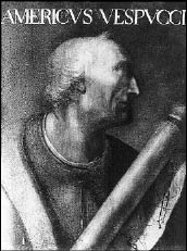
Amerigo Vespucci’s
first name gave the world America. But this Florentine navigator was also the first to realize that the Americas formed a continent between Europe and Asia—and therefore that the Atlantic was a discrete and separate body of water, an ocean.
The book was indeed wildly popular—helped no doubt by Vespucci’s loving discussions of the cosmetic self-mutilation, anal cleanliness, and sexual practices of the people he met along the way. It was a book that not only gave him personal immortality but also led to the explosion of European interest in the New World and the beginnings of a rolling tide of exploration and immigration that one mighty fairly say has not abated since.
The crucial sentence in Vespucci’s pamphlet stated simply that “[on] this last voyage of mine . . . I have discovered a continent in those southern regions that is inhabited by more numerous peoples than in our Europe, Asia or Africa, and in addition I found a more pleasant and temperate climate than in any other region known to us. . . .” He had found a new continent—or, more precisely, he had identified the land that he had found
as
a new continent, something that Columbus, some years before, had been entirely disinclined to do. To Columbus it was—and it wrongly was—an already existing continent: Asia. To Vespucci it was—and it correctly was—a totally new continent, and at the outset it was a continent without a name.
It fell to the Freiburg mapmakers to give it one. At the time the pair happened to be working in an academic community in the Vosges mountains of eastern France—and it was here that they got finally to christen this great body of land, and to offer it an identity it would then have for all time. Both of the mapmakers had read the
Mundus Novus;
both had read and were taken in by the more evidently forged Soderini Letter. Both agreed that in the preparation of an enormous new world map that had been commissioned from them, they would give, at least to the thinly sinuous southern part of the new continent that would be drawn on their masterpiece, a name. They would give it the feminine form of the Latinized version of Amerigo Vespucci’s Christian name: the properly feminine place nouns of Africa, Asia, and Europe would now be joined, quite simply, by a brand-new entity that they would name
America.
And so, in 1507, when the new map was published, and with images of the two giants of Ptolemy and Vespucci presiding in profile over an entirely fresh cartographic representation of the planet (but with neither Leif Eriksson nor Christopher Columbus in illustrated evidence anywhere), so, in large letters across the southern half of the southern continental discovery, just where Uruguay is situated today, was this single word.
America.
It was written in majuscule script, a tiny bit crooked, curiously out of scale and looking a little last-minute and just a little tentative—but nevertheless and incontrovertibly
there.
The name caught on. A globe published in Paris in 1515 has the word written on both segments of the continent, north and south. It was published in a Spanish book in 1520; another from Strasbourg five years later listed “America” as one of the world’s regions; and finally, in 1538, Mercator, the new arbiter of the planet’s geography, placed the phrasal titles “North America” and “South America” squarely on the two halves of the fourth continent. With that the name was fully secure; and it would never be changed again.
And with a new continent in place, so the sea that lay between it and the Old World continents of Europe and Africa—the sea that had variously been named the Ocean Sea, the Ethiopian
17
Ocean,
Oceanus Occidentalis,
the Great West Sea, the Western Ocean,
Mare Glaciale,
and by Herodotus in
The Histories
in the fifth century
B.C.,
the Atlantic
—became, at last and with certainty, a discrete and bordered ocean, too.
It was no longer appended to any other sea. It was no longer a part of some larger and more amorphous worldwide body of water. It was a thing—a vast and, back then, almost unimaginable thing, true—but it was a thing nonetheless, with borders, edges, coastlines, a rim, a margin, a fringe, a brink, and a northern, a southern, a western, and an eastern limit.
From a simply inexplicable green-gray immensity that stretched without apparent cease beyond the Pinnacle Point tide pools, to an even more frightening turbulence of waves and winds raging beyond the Pillars of Hercules, to a warm sea stained with purple dye or a cold sea choked with ice, and to a body of little self-importance and which was supposedly conjoined with other seas that lay far beyond, the Atlantic Ocean now at last, and from the moment of being given the early-sixteenth-century imprimatur of Mercator, had a proper identity, all of its own.
It remained now to find out just what that identity was, and to set this newfound ocean in its rightful place on the world stage.
The Atlantic had been found. Now it demanded to be
known.
Then the whining schoolboy, with his satchel,
And shining morning face, creeping like snail
Unwillingly to school.
1. THE DEFINING AUTHORITY
The Principality of Monaco, that sunny haven for shady cash on the French Riviera, is not a place sufficiently blessed by a noble history to be littered with an abundance of grand public statues. The parks and plazas naturally have plenty of marble representations of members of the Grimaldi family, the Genoese notables who have run the place since the thirteenth century. There is a kindly sculpted bust of Hector Berlioz, who is remembered for once falling over near the Opera House, and there is a dull bronze rendering of the Argentine speed demon Juan Manuel Fangio, standing beside the Formula One Mercedes in which he won so many of his local car races.
But those monuments aside, there is little other statuary of interest—except in the entrance to a rather anonymous-looking modern office building on the Quai Antoine the First, beside a harbor that is permanently jammed gunwale to gunwale with large cruising craft. There stands a striking and rather magnificent statue in polished teak, of the great Greek god of the Sea, Poseidon. He stands there decently naked, full-bearded, and wielding his trident in the stance of a guardian outside the little-known office that, since 1921, has defined, delineated, and approved the official names of all the many oceans and seas, bays and inlets on the surface of the planet.
The International Hydrographic Organization has been in Monaco since 1921, invited to this improbable setting
18
by the then ruler, Prince Albert I, a man who collected charts and portolans and had a fleet of research vessels, and held great admiration for and great knowledge of the deep-sea fish and marine mammals for which he went exploring. The organization he helped create has as members almost all of the oceanside states of the world—Algeria to Venezuela, by way of Jamaica, Tonga, and Ukraine, and with all the obvious big-sea countries among the founders.
One of its principal mandates is to define—in a de facto rather than a de jure sense—the boundaries of the world’s oceans and seas. This turns out to be a most contentious matter. Right from the start there was argument: “Your proposed western limit of the Mediterranean,” huffed a Moroccan delegate in the 1920s, when comments about the first proposed boundaries were invited, “makes Tangier a Mediterranean port, which it certainly is not.”
The original architects had thought fit to make the boundary of the North Atlantic Ocean pass on the outside of the entrance to the Strait of Gibraltar, a decision that appeared to unsettle everyone. So on instructions from the senior brass, the clerk promptly erased his first boundary line and drew in a second, a mile to the east of Tangier—elevating it at a stroke to the status of an Atlantic Ocean city, and not a mere Mediterranean port—and all were reported to be happy.
The IHO’s other important, practical remit is to ensure that all the world’s navigation charts look more or less the same. This is not quite as dull as it sounds. It stems from a conference held in Washington, D.C., in 1889, at which grim stories were told about ships’ captains who were compelled to use charts made by countries poorly skilled in chartmaking and so came to sudden grief on unmarked shoals or on the approaches to ill-drawn harbors. The only way such marine misadventures could be prevented, said the conferees, was for all charts and all navigational aids to be the same, and for all sailors’ maps, whether made in Britain or Burma, the United States or Uruguay, to adhere to exactly the same high standards.
At a navigation conference held in St. Petersburg, Russia, just before the Great War, the world’s navies and merchant mariners promptly urged that an international commission be set up to study such problems. Finally in 1921, once the European dust had settled, Monaco’s well-regarded Serene Prince offered room and board and a clutch of Monegasque typists (together with one charmingly styled “boy-attendant”) to help establish the IHO, which was then formally constituted and guarded by its pet Poseidon where it resides contentedly, if rather obscurely, to this day.
Its most important publication occurred in 1928. Back then, and costing thirty-five American cents, it was a handsome green-covered pamphlet, printed letterpress by the Imprimerie Monégasque of Monte Carlo and titled IHO Special Publication No. S.23, “Limits of Oceans and Seas.” In the twenty-four pages of this endearing publication one would find such official pronouncements as the formal description of the limits of the English Channel:
On the West: From the coast of Brittany westward along the parallel of the E. extreme of Ushant (Lédènes), through this island to the W. extreme thereof (Le Kainec), thence to the Bishop Rock, the SW extreme of the Scilly Isles, and on a line passing to the Westward of these Isles as far as the N. extreme (Lion Rock) and thence Eastward to the Longships, and on to Lands End.
The world may not have expanded in the years that followed, but the definitions and denominations of its seas, and the arguments among the countries that lay beside them, most certainly did. In consequence the size of this pamphlet grew, modestly at first, and then prodigiously. The twenty-four pages of the first edition grew to twenty-six pages in the second, and then thirty-eight pages in the third edition—but when the fourth edition was published in 2002, it had ballooned into 244 pages. Seas so obscure that only those who live beside them have ever heard of them now officially exist: there is a Ceram Sea, for example, a Cosmonauts Sea, an Alboran Sea, a Lincoln Sea, a somewhat tautological Sound Sea,
19
and scores upon scores of others.
Three senior naval officers from member states are elected to preside over the International Hydrographic Organization, usually for five years at a time. Before I traveled to Monaco to see them I had visions of this trio, all splendid in crisp blue uniforms and with coils of gold tassellage, ruling definitively on lofty matters of world navigation—on how best to define the new limits of the Kattegat, on demanding the mapping of where the Arafura Sea abuts against the Gulf of Carpentaria, on determining whether L’Anse aux Meadows was truly washed by the Labrador Sea or the Gulf of St. Lawrence. They would settle these quibbles while quaffing pink gins, smoking pipefuls of rough shag, and carving scrimshaw doodles on the side.
As it happened, two of the officers—from the navies of Greece and Chile—were away when I called one blissful midwinter morning, and the only sailor “on deck,” as seamen in offices like to say, was the representative from Australia. He turned out to be a middle-aged, full-bearded Briton in civilian dress, a man who had long ago left the Royal Navy for its Royal Australian counterpart and was now usually based in Melbourne. His driving passion was not so much ships and the sea—they were his job—but the building in his modest apartment in Villefranche of model railway layouts, HO scale.
Officially, however, he and his brother sailors spend a great deal of time wondering about, fulminating over and trying to reverse what they see as a general world ignorance of the oceans. The world’s seas may now have more names than ordinary man may care to know—that much seems true, but this is the fault of politicians and a consequence of national pride. What troubles the IHO, which, as mentioned, has as another of its mandates the creation of charts to help ships navigate safely around the world, is just how dangerously unaware most landlubbers are of what goes on beneath the surface of these bodies of water. To illustrate the point, they mention repeatedly one unanticipated statistic: even though mankind now knows the precise altitude of the entire surface both of the moon and Mars at points little more than five feet apart, he knows the altitude of the bottom of the sea only at points that are separated in many cases by as much as
five miles.
For all the hydrographic surveying that has been done over the years, all the soundings taken and the reefs plotted and the headlands marked, the admirals complain that the current inhabitants of the earth know far too little about their seas, even though oceans cover seven-tenths of their world. This is not for want of trying, however. Europeans especially have been attempting to divine the details of their ocean for the past five hundred years. Ever since Columbus and Vespucci came home, and ever since it became clear that Europeans were inevitably going to trade and fight their way across the Atlantic and all the other seas, there have been great national efforts—in Britain, in Portugal, in Spain, and in time in America and Canada and Brazil and South Africa, too—to survey and chart the waters, to find out the seas’ depths and shallows, their tides and currents, their races and whirlpools and the accurate measure of their coastlines, their islands and their reefs, and all the other features that mark them out so peculiarly. Educating the world about the ocean—with the knowing of Atlantic in the very forefront of the effort—was a venture that got under way as early as the fifteenth century, and it has not stopped for a moment since.
To survey an entire ocean required access to all of its farther limits—access that in the case of the Atlantic was for a long while frustrated by more than a few navigational challenges. The severest limit was the existence of a highly inconvenient sandstone headland known as Cape Bojador—a West African cape that the Arab sailors had feared for centuries and knew as
Abu khater
or
the father of danger.
2. THE ROADBLOCK IN THE WATER
The road into the Sahara south from the old Moroccan seaside fort city of Essaouira happens also to be the main trunk Atlantic coast road into West Africa—it passes on to Mauritania, and then to Senegal, the Gambia, Guinea-Bissau . . . With careful planning, good fortune, decent springs in your car, and a fair amount of time, a determined driver could make it to Cape Town, arriving in time for tea under the jacarandas at the Mount Nelson Hotel.
For most of its early miles, the journey has a steady tedium. After the spectacle of the Atlas Mountains dipping into the sea to which they gave their name, and after passing through the tiny Spanish enclave of Ifni, and after seeing the chains of great French-built lighthouses and the surfers carelessly riding the rollers thundering in from the sea, you drive inland for a few miles and the road becomes flat. The groves of argan-oil trees and goat-busy scrub eventually give way to the stony desert plains of the hammada, and there is a dreary little junction town called Goulmime, where the desert proper begins.
Beyond the dust and chaos of its medina—with blue-robed Touareg still to be seen, and desert-weary cameleers bringing trade goods for the souks—the two-lane highway, oil-dark against the sands of the hammada, winds empty over the horizon, with just the occasional tanker truck whooshing past, and fleets of rickety Mercedes taxis traveling too fast for their own good. The sea rumbles endless to the west, and there is the glint of the high ergs of the Sahara far to the east. The east wind constantly whistles, leaving grit in one’s hair and teeth. This until lately was the entranceway to Spanish territory, and one sees it in the landscape and the feel of the place. The north of Morocco possesses a certain silky plenitude, whereas this more southerly corner of the place has a harshness: dry, dusty, and stained with oil.
The towns are far apart, and generally worth stopping at only for fuel—though one of them has a monument to Antoine de St.-Exupéry, memorializing his time as a pony express pilot for the 1930s coast airmail service between Toulouse and Dakar; and there are plenty of fishermen’s huts where one can find grouper, swordfish, and sardine, plucked from the sea and grilled over driftwood fires. The coastline itself becomes more interesting, too. Near Tarfaya it turns abruptly out to sea, a fifty-mile change of direction jutting into the ocean and into which, over the years, scores of vessels with captains sleeping, stupid, or drunk have plowed: there are wrecks of fishing boats sitting high and dry and majestic on the rocks, all being slowly chewed away into nothing by the ever-digesting surf.
The seas here have a particular reputation for peril. From high up on the hills above this headland’s terminal point, Cape Juby, it is just possible to make out the closest of the Canary Islands, Fuerteventura. Until the ever-gnawing seas did their work, a famous shipwreck also lay here: the great transatlantic star of the fifties, the Virginia-built liner SS
America,
broke loose in a storm while being towed to Thailand in 1994 to be turned into a floating hotel. She now lies almost wholly sunk a hundred yards off a Fuerteventura bathing beach, a forlorn memorial to the brief greatness of America’s merchant marine.
• • •
It is indeed coastal danger that is most memorable along this stretch of the African shore. At latitude 27 north, some 150 miles south of the wrecks of Cape Juby, there rises a long, low headland, extremely undistinguished in appearance. This is a headland that remains hugely important in the history of Atlantic navigation, though in reality it is disappointingly not at all like those other famous Atlantic capes—Finisterre, Horn, Good Hope, Farewell, St. Vincent, Race—that are the stuff of great poetry and legend. This, more modest in its majesty and its menace, is Cape Bojador.
Though the Portuguese word
bojador
hints at “protrusion,” the land that makes up this low hurdle of cliffs is not a protrusion at all; nor does it pose anything but the smallest inconvenience to a vessel passing south along the African coast. But for many centuries no sailing vessel ever dared to pass it, nor was one physically able to do so.
Quem quer passar além do Bojador, Tem que passar além da dor,
wrote the modern Portuguese poet Fernando Pessoa.
He who wants to pass beyond Bojador, must also pass beyond pain.
Beyond it lay a totally unknown sea—a terror-inspiring, monster-filled wilderness known in all ports as the
Green Sea of Darkness.
Until the fifteenth century, no sailor—whether Spaniard, Portuguese, or Venetian, whether Dane or Phoenician, and by all existing accounts no African sailors, either—had ever successfully rounded Cape Bojador from the Atlantic Ocean side. All the early navigational academies of Europe regarded the sea beyond Bojador as quite impassable. Its very existence stands as one of the reasons why the central Atlantic Ocean, despite having almost certainly the world’s most populous shores, was the last of the great seas to be properly navigated. Polynesian navigators had long before crisscrossed the Pacific; Persians and Gulf Arab sailors had taken their reed-and-creosote sailing craft across upper parts of the Indian Ocean; Chinese sailors knew the intricacies of the eastern Indian Ocean and their various littoral seas; and the Vikings knew the navigational complexities of the far north. But traditional navigation seemed not to work so well or so speedily in the Atlantic as it did elsewhere, and Cape Bojador, so far as the literature records, was one of the reasons why.