Atlantis and the Silver City (20 page)
Read Atlantis and the Silver City Online
Authors: Peter Daughtrey

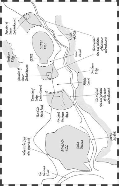
The distance given by Plato from the outer embankment back to the base of the hill was 925 meters (five stadia).
To arrive at precise comparative measurements is problematic. Thousands of years have passed and erosion has taken its toll, as have earthquakes and the resulting tsunamis surging up the river. I was surprised then that, calculated from the local authority’s own map, the current measurement from the east face of this embankment facing the town, back to what I thought would have been the approximate end of the grove at the base of the hill, was, incredibly, between 900 and 950 meters.
Plato said the area of water on the west side after this outer embankment was the city’s harbor. The current area to the west of the embankment remnant matches that description and is perfectly situated for a large harbor. Shelter is provided from the prevailing southwesterly winds by the high Rocha Branca headland and other hills. It also directly adjoins the river, and that it was once underwater is self-evident. After coming to this conclusion, the Silves archaeology department confirmed that it is believed that the area housed the Roman harbor. (
SEE IMAGE
26
IN THE PHOTO INSERT
.)
If the Phoenicians had established a base on the top part of the remains of the old embankment, it would have overlooked this harbor. As already suggested, this implies that it was positioned there for an important trading partner, almost certainly a rich city a short distance upstream.
The River Falacho also flows into the same large harbor basin from the north but now only contains an appreciable volume of water after seasonal rains. Thousands of years ago it would certainly have been more prolific and contributed to this whole area being permanently underwater.
So we have the remains of the outer embankment and harbor area exactly as described by Plato.
What, then, of the other inner embankment?
Logically, it was constructed linking in to those two limestone outcrop-pings on each side of the central hill. Both now have a property sitting on the highest point, but a lower, sheer face is still clearly visible where they had been cut away to allow the N124 road to pass. Plato intimates that Poseidon
built the embankments using the earth and rock from the excavation of the beds for the rings of seawater. There is no sign of this embankment continuing on the other side of the road, but that is hardly surprising after nine thousand years of being shaken by successive earthquakes, battered by tsunami surges, and the soil spread to help reclaim the land. (
SEE IMAGE
27
IN THE PHOTO INSERT
.)
Today the remaining cutaway face on the west side of Silves is about 130 meters wide. This limestone rock and the one to the east of the town would have protruded above the flooded plain and been the obvious keys on which to base this inner embankment. As these outcroppings are of white limestone, it would also explain Plato’s assertion that there was some quarrying on the first embankment. The rock outcroppings could originally have been much higher. They may also have extended farther sideways but then been quarried away by the succession of different cultures as they were conveniently situated for supplying rock to town builders.
The existing distance from the west side of the western outcropping, across it, and back to the the hill is approximately 550 meters. In clue 61, Plato said it was 555 meters (that is, one stadium of water plus two stadia of land). Then there was supposedly a further 370 meters of water (two stadia) from the west side of that embankment to the final outer one already discussed. Give or take a few meters, that is the same as it is today. I think you will agree that these measurements are quite an astonishing match. Even now, the remnant of the outer embankment is of quite a height, indicating that the banks were “raised considerably above the water” (clue 60).
We have a problem, however, with Plato’s contention that these embankments were at all times equidistant from the hill as though “turned with a lathe” (clue 26).
Again, it is extraordinary detail. Plato was obsessed with mathematical precision. Others have pointed out that he may have copied the idea from cities with rings of encircling land, which were fashionable around Plato’s time. The famous harbor at Carthage has often been cited as an example.
Unless there have been considerable upheavals in the terrain surrounding Silves (more of that later), the embankments and water channels could not have been uniformly equidistant from the hill, apart from the first one of water closest to the city. The other embankment and water channels, if they
continued unobstructed all around, would have had to be elliptical, much closer together and narrower to the north and south due to the natural contours of the land. (
SEE IMAGE
28,
OPPOSITE PAGE
.)
Plato’s circular description could then be explained by the view that any visitors would have had from the Phoenician base on that far western embankment. They didn’t have Google Earth to consult, or bird’s-eye views from helicopters. Looking toward the city, they would have seen the next stretch of water glistening in the bright sun, then the next embankment looming over it and circling around away from them, backed by the city. With the diminishing perspective, they would not have been able to ascertain exactly what happened with the embankments and water north and south of the city—and certainly not what happened to the east.
Most likely, they would not have been allowed to venture any farther than the harbor, as that was the principal purpose of the whole layout: privacy, to keep out anyone other than those specifically invited.
All trade would have been kept to the harbor area to avoid impinging on the daily routine of the city. They could have gained a better indication of the layout had they been allowed to climb the high land to the south of the city, but were more likely to have spent their time carousing and enjoying the delights of the harbor front.
So we have evidence that embankments could have existed, separated by water, and measurements taken westward from the city correlate amazingly accurately with those quoted by Plato. That is quite remarkable in light of the huge timespan. The fact that it could not have been exactly as Plato indicated could again be credited to a misunderstanding, or to his attempting to make the story more impressive—or to the distorted view obtained from the outer embankment.
Also, it cannot be discounted that the terrain to the north and south of Silves could have changed at the time Atlantis was originally destroyed. The convulsions that engulfed the area were obviously profound, and it is not unheard of for contours to dramatically change. In 1692, for instance, Port Royal, the infamous pirate den in the Caribbean, was destroyed by an earthquake. The town sank below the waves, and two mountains moved a quarter of a mile. The enormous pressures caused by two continents in collision are suddenly released as the plates move. It is how mountains were originally formed.
(
IMAGE
28)
Chart depicting the remnants of the embankments around Silves, their relationship with the original larger ones, and how these would have compared with Plato’s measurements
.
Now we have eighteen matching clues:
14. The outer embankment in the correct position from the west.
15. It was of considerable height.
16. The large sheltered harbor area in the correct position.
17. The points used to key the inner embankment, again in the correct position to the east and west of the hill.
18. The surrounding mountains.
One clue that cannot be reconciled with Silves is the stone wall that Plato said encircled the capital at a radius of 9.25 kilometers (clue 81). It would have been yet another huge construction project almost 100 kilometers long, but, considering the Great Wall of China and the Roman Hadrian’s Wall from coast to coast across northern England, possibly achievable.
The problem is the 40-kilometer-deep tract of mountains immediately behind Silves and to a lesser degree to the sides. They are not massively high, but the majority of the hundreds of conical/pyramid-shaped hills have sides sloping at around forty-five degrees. Although I haven’t walked the supposed perimeter, to my knowledge there are no vestiges of such a walled structure to be seen anywhere. Plato also said these mountains had originally been higher than still existed in his day, indicating that they had been subjected to a massive shakedown at the time the southern plain disappeared. There is also the possibility that the whole area remaining above water had been simultaneously lowered in height just as the seabed was.
Why would the Atlanteans have wanted to build this extraordinary extra defense anyway, when the area immediately around the citadel sounded pretty well impregnable? It would be like deploying an anchor on a car with modern ABS brakes.
What were they afraid of? In the case of Hadrian’s Wall, it was to counter a definite threat, the constant niggling of raiding parties from the fiercely independent and resentful Scottish to the north. Atlantis would not appear to have had problems like that; the province ruled by Atlas was surrounded by others ruled by his brothers. Surely he did not need defenses against them—they were part of a family alliance.
The only threat could have come from the sea, but, given the high cliffs on the immediate coast, any invasion would have to have approached via a river mouth. These would have had towns and ports and would have been fortified with defensive emplacements if there was any hint of danger. Even today, the mouth of the Arade River flowing down from Silves has an old fortress on one side and a small castle on the other, very picturesque for the passengers on the cruise liners that now regularly dock there.
Plato’s account contains no indication of invaders; it was, in fact, the Atlanteans who are ultimately painted by him as the aggressors, but even that has been suggested as an embellishment by many researchers.
What would happen to the wall where that wide encircling canal/reservoir had to pass through it twice, not to mention numerous substantial rivers? There would have been a breach of some sort at many points, as well as at the 700-meter-wide river mouth that gave access to the city upstream.
Given the immense time scale (around 11,600 years), however, together with the violent seismic upheavals and the usefulness of the hewn rock for subsequent building, it is hardly surprising that no vestiges remain. If, that is, it ever existed.
Finally, clues 24 and 25 do not, at first sight, support the case for Silves: “Near the plain again, and also in the center of the island at a distance of about fifty stadia, there was a mountain not very high on any side.” Over the years, the precise meaning of this clue has been much debated. Did Plato mean in the center literally, from east to west? Or in the center from the sea? Just before mentioning that, in clue 23, he indicated that the plain was bordering the sea to the south but in the center of the kingdom. If he had meant in the center of the
island
from the coast, the plain could not have been bordering the sea. He obviously meant from east to west. It seems reasonable, therefore, to adopt the same interpretation about the city, although it would be easier to present a case for Silves complying with the alternative. He was indicating that it was in the middle from side to side, but fifty stadia (9.25 kilometers) by water to the coast.
When referring to the center, he would only have been giving an approximation, not meaning absolute dead center; that is, nearer the middle rather than closer to the west or east. Indeed, it has been suggested that the wording Plato used translates as “around the center.”
Today Silves would fall outside these parameters. It could have been 9.25 kilometers from the sea, as it still is, but be in the western segment of the entire homeland. But, I reasoned, if a large area of land had sunk or been submerged by rapidly rising sea levels, the original distances would have been affected. The sea chart indicates that the land originally extended way west from Cape St. Vincent. I drew a horizontal line across from the western limit of the now-submerged land to a line level with Cádiz. It indicated a distance of about 280 kilometers.
From the same point at the western edge, Silves would have been around 100 kilometers distant, making it nearer the center (140 kilometers) than to the eastern or western limits. Plato said that the kingdom was divided into areas to give to Poseidon’s various sons to rule. If Silves was the capital, it would have been part of the central region, not the eastern or western. There is also the near certainty that the southwestern tip of the Algarve once extended much farther toward the Gorringe Bank. That could have been enough to even up the discrepancy.
I still had one last obstacle to overcome, however, one that may well have already occurred to you. Silves is 9.25 kilometers from the sea today; but what of 11,600 years ago? If a large area of land to the south of it that existed then is now submerged, it must surely have been farther away from the coast.