Atlantis and the Silver City (7 page)
Read Atlantis and the Silver City Online
Authors: Peter Daughtrey

Living in the Algarve, it would be an understatement to say that I was perturbed on discovering this. Was I to live with the possibility of all hell breaking loose at any moment? I resolved to find out whether this was a one-off or part of a sequence of similar events. The answer was to be found in the findings of several recently conducted surveys.
15
In one, core samples were drilled out of the Atlantic seabed between Cádiz and Gibraltar. This is well within the zone this disaster has been traced to. It seems that tsunamis cause characteristic sediment to be deposited on the seabed. By analyzing the depth of each layer, the strength of the event can be accurately deduced, and its depth in the overall strata indicates when it occurred. The bad news is that events of the ferocity of the 1755 earthquake happen regularly and will continue to occur. The good news is they only occur infrequently—every 1,250 to 2,500 years. This means the next one should not be troubling the area for at least another thousand, or even two thousand, years. I breathed a big sigh of relief, but still I made sure that I had quake insurance.
A survey, by Dr. Marc-André Gutscher of the University of West Brittany in France, looked for layers of turbidite (sand and mud) shaken up by underwater avalanches caused by earthquakes; the survey was published in the journal
Geology
. He found a 50- to 120-centimeter-thick sedimentary deposit, left by a huge tsunami around twelve thousand years ago.
16
That is very close to the date given by Plato for the destruction of Atlantis.
A combination of my natural curiosity and imagination kicked in. What momentous changes must have taken place in the Algarve over these past twelve thousand years? In 1755 alone, there was a 30-meter subduction (lowering) of the seabed over a 300-kilometer radius. It almost certainly reached as far as the Algarve, with the seabed dropping about 100 feet. Some dry land was most likely affected too. A few of the events may have been even stronger than the 1755 quake, and the occasional epicenter could have been farther east, more directly in front of the coast.
A short time before I started this book, in September 2009, there was an earthquake in the Algarve measuring 4 on the Richter scale. It wasn’t strong enough to cause serious damage and was just one of innumerable small quakes, causing absolutely no problems, experienced there every year. According to experts, these frequent minor quakes are advantageous, since
pressure is released in small doses rather than building up. This recent example, however, was ominously in front of Faro, the Algarve’s capital city, plumb in the middle of the coastline and therefore much closer than the 1755 quake.
Having always been fascinated by ancient civilizations, I had often wondered why none are recorded to have flourished in this corner of Europe where conditions are about as ideal as it’s possible to get: a perfect climate, productive plains, plentiful rivers, wooded mountains, and rich, verdant valleys, all skirted by bountiful seas. It would also have provided a superb refuge from the Ice Age and, lying at Europe’s most southwesterly point, offered a natural departure point for maritime exploration.
Now it was becoming apparent to me why no records exist. If there had been any flowering of civilization here, it would probably have been annihilated subsequently, over millennia, by earthquakes, tsunamis, and floods. Buildings would have been shaken down, buried under huge alluvial deposits, and the debris would have been sucked out to sea. Any rare survivors in the mountains would have gotten the hell out, terrified that they might be engulfed again. The Algarve’s coastline could well have once extended much farther out into the Atlantic but could also have progressively sunk in successive violent tremors, as well as being engulfed by rising sea levels.
I sensed there was something tantalizingly hidden here; my antennae were twitching. An urgent visit to the local harbormaster’s office was called for; I wanted to find out what the seabed in front of the Algarve was like.
CHAPTER FIVE
A Forgotten World
“A
re you serious?” I stammered. A local historian and friend, Jonathan Wilson, could not have stunned me more if he had suddenly heaved me in the river. We were sitting outside a café on the long estuary promenade in Portimão, a port town at the mouth of the Arade River in the Algarve. He had agreed to let me tap into his considerable knowledge of the area’s history over the past twelve hundred years. Jonathan, a former London barrister, now lives in Silves, the old Arab capital, a few kilometers up the Arade. Soon after arriving in the Algarve, he developed a passion for the town’s tumultuous history and the conflicts that took place there between the Arabs and the Crusaders. The latter helped to free it from the Moors on their way to the Holy Land.
We were verbally rummaging around the earthquake phenomena when he casually asked whether I’d heard of the submerged city. While translating a centuries-old Portuguese book about the Crusaders’ assault on the Algarve—and on Silves in particular—he’d come across a throw-away comment indicating that in 1755, as the sea had receded from the coast before the impending tsunami, a settlement standing on the seabed was clearly visible. Jonathan knew of no other reference to these remains, and my own subsequent research also drew a blank.
It appeared that there had been no local legends about anything being swallowed by the sea.
I was elated: this supported my fledgling hypothesis that the area must at some stage have developed and supported an earlier civilization.
Having mulled it over for a few days and made further inquiries, it became obvious that this submerged settlement must have been of considerable age. If it had suddenly sunk, with the possible exception of a few grander stone edifices, the building style of ordinary dwellings in the Algarve over the past two thousand years would not have survived under the sea for long. Walls were made from clay, mud and bits of pottery debris, and small stones mixed with lime and left to dry, compressed tightly between planks of wood. This dried to a hard consistency and, if the outside was regularly coated and the roof maintained, withstood the elements well. Permanently submerged under the sea and washed twice a day by the strong Atlantic tides, however, it would have deteriorated quickly.
If, on the other hand, the settlement had been engulfed over time by slowly rising sea levels, the pounding of the tides would have wreaked havoc. My inquiries, however, produced no local records, legends, or folk memory of a sunken settlement. It all indicated that the buildings must have been of a great age, disappearing below the water before living or recorded memory, and probably built from large blocks of hewn stone in a similar manner to that used by ancient civilizations. For it also to have withstood the effects of the 1755 quake, and perhaps others before it, indicated that the structure was quite possibly in the very ancient polygonal cyclopean style, with large, irregular, different-sized blocks carefully cut and fitted snugly together. This is recognized to be a highly effective way to absorb serious tremors. The buildings of the Maya people in South America are just some of the ancient examples. Others can be found in Egypt, Malta, Iraq, even Morocco.
The only other known peoples who had possibly built in a sufficiently durable way would have been the Romans. It is known that the Algarve coastline has been eroded since their era, two thousand years ago. But if this settlement had been Roman, I doubt whether that would account for the current position of the submerged remains in an area famous for its
cliffs. If it was on land being inexorably eaten away by the sea, it would have collapsed as the cliff below it avalanched onto the beach. Parts of Roman remains have been discovered on cliff edges, the missing parts having been consigned to the sea long ago. The exact distance from the shore was not disclosed in the old history book, but the evidence would appear to indicate these remains are farther out to sea with subsidence appearing to be the more likely cause—and who knows how large an area was affected? I have just discussed an estimated 30-meter drop over a radius of 300 kilometers as a consequence of the 1755 earthquake, and there were many others of similar or greater intensity before it.
If here was evidence of one sunken town, it was most unlikely to have existed in isolation in such a fertile area. My excitement barometer rose: cities could be dotted all over the seabed out there. What enlightening surprises could be in store from ruins that have lain unnoticed and forgotten for many thousands of years, finds that might change our whole perception of the world’s history!
After leaving Jonathan, I visited the harbormaster’s office just along the seafront and purchased a large bathymetric map showing the levels and contours of the seabed in front of the Algarve.
Arriving home, hardly able to contain my curiosity, I grabbed a Bible and a dictionary, the two heaviest books to hand, to weigh down each end of the map as I unfurled it on the dining table. This was turning out to be quite a day; I was in for my second major surprise. The seabed directly in front of the coast was pretty well flat and extended way out to sea, to a distance varying from 6 to 30 kilometers, with only a gentle slope. It looked like a large plain had been flooded. Interestingly, it finally reached a depth of around 120 meters before plunging sharply to around 200 meters. One possibility was that the original plain had once been fronted by cliffs, much as most of the western end of the Algarve is today. Dotted around this submerged plain were gray spots marked as “rocky areas.” I doubted whether any of these had been examined to determine whether they just might be submerged ruins.
A second flat area, sloping by roughly the same gradient as the first, continues out for a distance varying from 2 to 6 kilometers. Again this falls over a much steeper drop. There is then a third plain, only gently
rising and falling in parts, as it is also mostly very flat. It extends from a farther 20 kilometers out in front of Portimão in the western Algarve to 47 in front of Faro in the center, before again culminating in a drop that, like the others, is much steeper in some areas. The most precipitous part is at its extreme distance from the existing shore, where it finishes in what must have been a cape almost due south of Faro. It ends in a much higher area topped by a couple of rock-outcrop mini-peaks, not far below the surface.
The submerging of one of these plains could be explained by the melting of the glaciers that used to cover much of the northern hemisphere. This happened from around 16,000
B.C.
to 11,000
B.C.
(estimates vary). As a result of this meltdown, the sea is thought to have risen by around 100 to 120 meters worldwide. The submerging, however, could equally well be a result of sinking during a serious earthquake like that in 1755, or the combined effects of several of them. (
SEE IMAGE
4,
NEXT PAGE
.)
The seabed map showed one more fascinating aspect. The bed of the Arade River, beside the mouth of which Jonathan and I had chatted, was clearly shown extending way out under the sea, with its original wide mouth at the point of the third submerged cliff, clearly indicating the limit of an earlier coastline. The first part of the riverbed closest to the existing coast appears to have been filled with drifting sand and alluvial deposits; but the old, original bed farther out to sea is clearly shown. This was evidence that the seabed on either side, between it and the current coast, had once been above water. Intriguingly, this old riverbed reached incredible depths compared to the surrounding land: as deep as four thousand feet. Indeed, the map names it the Portimão Canyon.
A few thousand years ago, there would have been huge volumes of water flowing from it into the sea, as just upstream it was joined by two other, then mighty, rivers. Today, the Arade and one of the other rivers, the Odelouca, are dammed to provide freshwater reservoirs. I assumed that the sheer volume and speed of the flow would have worn this deep chasm in the soft sandstone bed. From later discussions with a local geologist (detailed in a later chapter), it appears that it is a natural geological phenomenon caused by the pressures of that fatal fault line farther out to sea. Not surprisingly, the river found and enlarged it.
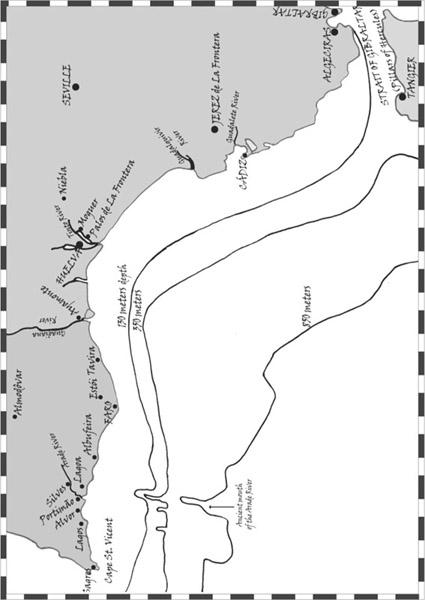
(
IMAGE
4)
The seabed off the Algarve and the Costa de la Luz, showing the extent and ultimate depth of each of the three old plains
.
It had been quite a day, and that submerged settlement might yet provide the first physical evidence. There were lots of pointers indicating that it was certainly worth continuing my inquiries. It was time to ramp up the investigation and examine the history of the area as far back in time as I could trace. Maybe the region’s remote past would throw up more lines of inquiry.
CHAPTER SIX
Untold Wealth