Frozen Earth: The Once and Future Story of Ice Ages (24 page)
Read Frozen Earth: The Once and Future Story of Ice Ages Online
Authors: Doug Macdougall
Tags: #Science & Math, #Biological Sciences, #Paleontology, #Earth Sciences, #Climatology, #Geology, #Rivers, #Environment, #Weather, #Nature & Ecology, #Oceans & Seas, #Oceanography, #Professional & Technical, #Professional Science

The ice age that occurred near 300 million years ago is sometimes referred to as the Permo-Carboniferous Ice Age, after the two geological periods that it spans, the Permian and the Carboniferous.
There is evidence that the Earth was cold for about 80 million years, from 340 until 260 million years ago.
During this very long span of time, there were many cycles of glaciation and deglaciation, much as has occurred during the current ice age, although because of their great antiquity, it has not been possible to work out the timing of these cycles with any confidence.
Whether or not they were influenced by astronomical cycles is also not known, but given the importance of orbital variations for the Pleistocene Ice Age, it is likely.
Wegener—the same Wegener who worked together with Wladimir Köppen and Milutin Milankovitch on past climate and ice ages—was putting together his theory that the continents had moved about over the Earth’s surface, he searched for geological features that appeared to be continuous across now-separate continents.
He was especially struck by the widespread evidence for the Permo-Carboniferous glaciation.
Glacial deposits had been reported from all of the southern continents—India, Southern Africa, South America, and Australia—and as far as could be determined, the glaciation had been roughly contemporaneous.
Wegener realized that a single, very large, continental ice sheet could account for all of the deposits if these now widely spread localities had once been contiguous.
That would require closing up the Atlantic Ocean so that Africa and South America were joined, pushing India up against the eastern coast of Africa, and somehow attaching Australia to this group of continents.
In addition, the problem of explaining how glaciers could exist in the tropics would disappear if his theory of continental drift were correct—the great agglomeration of landmasses could have been located much farther south, near the South Pole, at the time of glaciation, and only later drifted to their present, much warmer, localities.
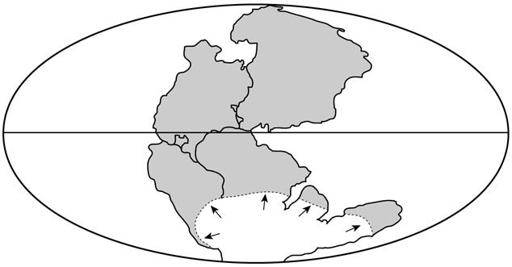
Figure 18.
At the time of the Permo-Carboniferous glaciation, the Earth’s land masses were joined in the supercontinent Pangea, which stretched from the South Pole to northern latitudes.
The current southern continents—Africa, India, Australia, and South America—were clustered together with Antarctica near the South Pole, in a landmass referred to as Gondwanaland.
Ice sheets spread northward to at least 40° south latitude.
Although it turned out that Wegener was right about mobile continents, his theory was heavily criticized and did not immediately settle the controversy over the Permo-Carboniferous glaciation.
Wegener was quite selective in his choice of evidence for continental drift, and he simply ignored things that seemed contradictory.
He also could not identify a satisfactory mechanism for moving the continents about—his one suggestion, that centrifugal forces associated with the Earth’s rotation might be responsible, was quickly demolished by his opponents.
As a result of these difficulties, the theory was generally discounted, and with it the idea that the Permo-Carboniferous glaciation occurred when the southern continents were joined together and located near the South Pole.
It was not until almost half a century later that the concept of continental drift was resurrected and transformed into the modern theory of plate tectonics.
But present-day reconstructions of the southern continents at the time of the Permo-Carboniferous glaciation show that Wegener’s conclusion was essentially correct.
Africa and South America had been joined together like pieces of a jigsaw puzzle, with India snuggled up against Madagascar on the east coast of Africa.
The Antarctic continent and Australia were firmly attached and nestled along the southern tips of Africa, South America, and India.
This entire supercontinent, referred to by geologists as Gondwanaland, had been centered near the South Pole throughout the long Permo-Carboniferous Ice Age.
When locations of the glacial deposits are plotted on the fused-together continent, they reveal the former presence of a single large ice sheet (figure 18).
The development of the theory of plate tectonics also solved a related puzzle.
Glacial markings often reveal the direction of ice flow, and some of the striations and scratches left by the Permo-Carboniferous
glaciation indicate that the ice flowed from the sea onto the land, at least in terms of the present-day configuration.
In India, for example, they show ice moving inland from the Arabian Sea.
The evidence is unambiguous, but because ice flows downhill under gravity, the conclusion appeared to early geologists to be impossible.
Glaciers form on land and flow into the sea; how could great thicknesses of ice build up in the ocean and spread onto the land?
But with the continents joined together as Gondwanaland, there were no intervening seas.
Ice simply flowed outward from its thick center across the present-day continental boundaries, creating the impression—after the continents were separated—that it had flowed inland from the oceans.
The most reliable dating of the Permo-Carboniferous Ice Age suggests that its maximum extent occurred during a span of about 20 million years, from approximately 280 to 300million years ago, and that ice sheets extended over the supercontinent of Gondwanaland to at least 40° south latitude, and perhaps even to 35° S or less.
That equals or exceeds the maximum spread of the Pleistocene glaciers in the Northern Hemisphere during the current ice age, and it is reasonable to infer that the volume of ice at the height of the Permo-Carboniferous glaciation exceeded the maximum, so far, of the Pleistocene glaciation.
But how do we know this?
How can the latitudes of, say, Buenos Aires or Cape Town three hundred million years ago be determined, when we know the continents have continuously moved about on the Earth’s surface?
The
relative
positions of the continents can be worked out quite far back into the past, but locating them with respect to the poles is a more difficult problem.
And yet estimating the extent of ice sheets, particularly estimating how closely they approached the equator, is crucial for determining the severity of an ancient ice age.
Fortunately, the Earth’s magnetic field provides a tool for this problem, just as it does for the timescale of deep-sea sediments.
The field is very close to one that would be produced if there were a gigantic bar magnet inside the Earth.
Viewed from space, it would look just like the textbook example of iron filings sprinkled around a bar magnet: the field lines
form great arcs that join the magnet at its top and bottom and bulge outward at its sides.
And at every latitude, the field has a specific orientation relative to the Earth’s surface, ranging from 90° at the poles to 0° at the equator.
As was discussed in the previous chapter, some minerals line up their internal magnetic fields with the Earth’s when they form, just as the iron filings line up with the field of a bar magnet.
And because the orientation of the Earth’s field depends on latitude, such minerals essentially encode the latitude in their physical properties at the time of their formation or when they are incorporated into a sedimentary layer.
In favorable cases, the magnetic information can be deciphered in the laboratory, and although it’s not always possible to tell which hemisphere the rock formed in (the inclination of the magnetic field to the surface is the same at equivalent latitudes both north and south of the equator), it is possible to determine the critical parameter for glaciation, how close it was to the equator.
Like most geological records, the evidence from rock magnetism gets more and more fragmentary as one delves farther and farther back into geological time, but for the Permo-Carboniferous glaciation, the data are abundant.
Not only can the positions of the continents that made up Gondwanaland be located quite precisely, but it’s also possible to reconstruct how the supercontinent drifted slowly across the South Pole during the long ice age.
The record left by the ice itself is fully consistent with the magnetic evidence, for it shows that the center of the ice sheets—the region from which ice flowed outward in all directions—stayed roughly fixed in latitude near the pole as the continent drifted slowly through the region.
Today’s northern continents seem to have largely escaped the Permo-Carboniferous glaciation.
This too is consistent with the magnetic evidence, which indicates that they were not then located in polar regions.
Only parts of what is now Siberia extended to high northern latitudes; North America and Europe were farther south.
There are some signs of localized glaciers in Siberia, but in Europe and North America, the tillites, glacially scratched rocks, and other ice effects that exist in the
former Gondwanaland are absent.
But there is one striking feature of the geologic record in these regions that has been linked, indirectly, to glaciation: an abundance of coal deposits.
The Carboniferous period derives its name from the widespread carbon-rich deposits that occur in this interval of geologic time.
They are mostly made up of the remains of spore-bearing plants similar to ferns, plants that lived in lowlying, moist environments often referred to as coal swamps.
The organic debris that accumulated in these swamps formed peat deposits; these in turn were eventually transformed into coal.
A peculiar feature of the Carboniferous coal deposits in North America and Western Europe is that they are cyclical: beds of coal alternate with marine sedimentary rocks such as limestone or shale in a pattern that is repeated many times over.
In places as many as a hundred cycles occur; although it is difficult to determine the amount of time represented by each cycle, in aggregate it is estimated that they span ten million years of deposition, or even more.
The plants that were the precursors of the coal grew in fresh or slightly brackish water, and it is believed that many of the coal deposits formed in lowlying coastal swamps that were periodically inundated with seawater.
With each flooding the accumulated peat was buried beneath a layer of ocean sediment; between floodings the fresh water swamps reestablished themselves and new layers of peat accumulated.
The pressure and heat of burial eventually transformed the multiple peat layers into the cyclical coal deposits that characterize the Carboniferous.
The link between coal deposits and the Permo-Carboniferous Ice Age has to do with the repeated flooding of the coal swamps, which was most likely due to rising and falling sea level.
All glacial ice has its source in the ocean through the Earth’s ongoing cycle of evaporation and precipitation; if all the water currently frozen in the Greenland and Antarctic ice caps were returned to the ocean, sea level would rise by about 60 meters, more than enough to drown a coastal swamp.
At the height of the Permo-Carboniferous glaciation, the amount of water locked up in the ice sheets was probably equivalent to somewhere
between 150 and 250 meters of ocean depth.
Even if only a fraction of these ice sheets melted and then reaccumulated in glacial-interglacial cycles similar to those of the Pleistocene Ice Age, the resulting changes in sea level would be quite sufficient to explain the cyclical Carboniferous coal deposits.
The cause of the alternating warm-cold periods of the Permo-Carboniferous Ice Age is unknown, but their regularity hints at an astronomical or other external “pacemaker,” just as it did for the current ice age.
The Permo-Carboniferous Ice Age was long and severe, with vast regions of the southern continents buried under ice that extended from the South Pole to low latitudes.
Although life on Earth was not nearly as diverse 300 million years ago as it is now, the existing fossil record shows that it was significantly affected.
Throughout the Gondwanaland supercontinent, the diversity of plant life dwindled, and the species that survived were hardy varieties adapted to harsh climatic conditions.
But as severe as the Permo-Carboniferous glaciation was, it has gradually become apparent that there was an earlier period in the Earth’s history that was even worse.
Although there is lively debate about just how much worse it really was, there is general agreement that it was probably the most pervasively cold era in our planet’s history.
Some researchers contend that the entire planet was frozen—not only was there ice on the continents, but the ocean surface was frozen as well.
This has been called the Snowball Earth hypothesis.
Those who opt for a slightly less extreme climate refer to Slushball Earth.
Regardless, it was intensely cold, much colder than the Earth has ever been in human experience.
Snowball Earth occurred about 300 million years before the Permo-Carboniferous glaciation, during the long interval between 550 and 850 million years ago.
Several separate ice ages may have occurred during this period, but the uncertainties in dating glacial deposits and the difficulty of correlating from continent to continent mean that the entire interval is usually referred to as a single ice age.
It occurred near the end of the Proterozoic eon of the geological timescale, and to distinguish it from other icy episodes, geologists refer to it as the Late Proterozoic
glaciation.
The Late Proterozoic Earth was a very different world than the one we know today—plants and animals had not yet appeared on land, and only relatively primitive life inhabited the sea.
The continents were mostly barren rock, the oceans contained no fish or lobsters or seaweed, and there is good evidence that even the atmosphere was quite different, with much less oxygen than at present.
Because the Late Proterozoic Ice Age happened so long ago, the evidence of glaciation, although very strong, is fragmentary.
It remains only in places where it could be easily preserved, usually places that were already submerged at the time of glaciation, or were lowlying and later flooded by the sea as the glaciers receded.
In such environments, glacial drift, scratched and scoured bedrock, and other glacial features were buried under sediments and stored for hundreds of millions of years—and later uplifted again for geological inspection today.
But in spite of the rather stringent conditions required for its preservation, the evidence for glaciation during the Late Proterozoic is widespread.
It is found on every continent, suggesting that ice sheets were present throughout the globe.