Grid of the Gods (47 page)
Authors: Joseph P. Farrell,Scott D. de Hart

consists of an outer rim of sandstone slabs with four sets of larger gate stones that form two (lines) of sight “windows” in the calendar circle. Inside the circle are six larger stones. The largest of the slabs are almost three feet long, and the smallest are slight less than a foot. The circle is ten to eleven feet across.
8
However, in addition to this, it was eventually discovered that the site possesses
two further subterranean
levels buried beneath the earth,
9
thus making the entire site a complex three-dimensional object that, as will be shown, exhibits an extraordinary degree of knowledge and deliberation in the way it was constructed.
1. The Celestial Alignments
The complex sophistication of the knowledge and deliberation that went into the construction of Nabta Playa is evident in the first level of the site, the surface “circle” itself, for there are a host of astronomical alignments and other celestial features encoded in the structure. The first, and most obvious, of these alignments also immediately confronts one with an anomaly:
Three of those central six stones are a diagram of the constellation of Orion’s Belt as it appeared on the meridian around summer solstice from 6,400 BC to 4,900 BC. The “meridian” is simply the line in the sky that passes north to south, and is thus the midway line or “meridian” across which stars pass in their nightly travels from rising in the east to setting in the west. Thus the inside of the calendar circle had a clear use as a star-viewing diagram.
10
Therein lies the anomaly, and it is a somewhat anachronistic one, for as most people are aware, the Egyptian religion was fixated upon the constellation Orion and evolved a complex mythology of death and
resurrection fastened around the gods Osiris, Set, Isis, and Horus. The constellation became, for them, a veritable seal of the concept of Osiris’ resurrection. The six megaliths in the center of the Nabta Playa circle were, when compared with reliable modern astronomical star charts, clearly meant to represent the six stars of Orion: Alnitak, Alnilam, Mintaka, Betelgeuse, Bellatrix, and Meissa.
11
So what is a structure doing in the Egyptian desert that antedates the oldest Egyptian structures, and the Egyptian religion, itself? Or to put it differently: why the fixation on Orion?
To make the chronological anachronism and anomaly very much worse, Brophy soon discovered that there were
earlier
alignments encoded within the calendar circle. Three of the stones, as was noted, pointed to alignments ca. 4,900 to 6,400 BC. But there was a problem with the other three:
The apparent significance of the other three central stones in the calendar circle is more difficult to reconcile with prevalent assumptions about prehistory. These other three stones are a diagram of the configuration of Orion’s head and shoulders as they appeared on the meridian on summer solstice sunset in the centuries around 16,500 BC. That date is symmetrically opposite the 5,000 BC congruence of the Orion’s Belt stars, in terms of the precession of the equinoxes, and both dates are at the extremes (maximum and minimum) of the tilt angle of the Orion constellation.
Thus the stone diagram illustrates the time, location, and tilting behavior of the constellation of Orion through the 25,900 year equinox precession cycle, and how to understand the pattern visually.
12
Lest one be tempted to use this earlier alignment as a means to date the structure, Nabta Playa has surprises in store, for it is a clear example of a
younger site clearly encoding alignments that antedate its construction by several thousands of years:
The case for the southern three stones in the diagram is also strong, but it is troubling to some investigators because there is no evidence yet of activity circa 16,000 BC at Nabta Playa, and the calendar circle couldn’t be that old because it sets on younger
sediments, and there is bias against the idea that ancient people could have known that the constellations change tilt long term due to the precession of the equinoxes.
13
In other words, someone in pre-dynastic times in Egypt had accurate knowledge of the precession of the equinoxes and had encoded the entire cycle within the calendar circle.
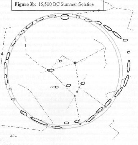
Brophy’s Chart of the 16,500BC Summer Solsticial Alignment
14
None of this, however, was beyond the ability of primitive peoples either to observe or to enshrine in structures with their primitive technology:
…(It) should not be assumed that ancient sky watchers could not determine geometrical heliacal risings, even without the use of technology or mathematics, if they wanted to. An astute observer would simply watch the rising of the star for several days during the year while the star’s rise was clearly visible. If the ancient sky watcher knew when vernal equinox was, he would simply extrapolate the star rise time of day to vernal equinox and determine if it would be a geometrical heliacal rising. That is a very achievable feat for an accomplished ancient megalithic astronomer even without technology or mathematics.
Thus so far in this analysis of the Nabta megalithic astronomy these alignments could possibly have been designed by ancient peoples with the usually assumed low level of Stone Age technology. The designers displayed astonishing elegance and clarity, but plausibly they could have done it with primitive technology.
15
But this easy explanation collapsed when Brophy then turned to deeper and closer analyses of the calendar circle.
One of the first clues that suggested to him that he was dealing with a structure requiring far more knowledge and sophistication than merely Stone Age technology was when he compared the analogues of
distances
between the stones in the circle that represented stars, and their modern astronomical measures, incorporating standard errors. The result? The measures of the Nabta Playa circle, when compared with modern astronomical measures, were astonishingly accurate.
This is the first very important result of this analysis of the Nabta Playa megalith map. Star distances are difficult to measure. Modern science’s best estimates of star distances, based on astrophysical
models of star evolution, were very erroneous until recently. Only with the launcing of the Hipparcos satellite observatory, above the atmosphere, have we been able to directly measure parallaxes (parallaxes are the different angles measured to a star as the Earth travels around the Sun) and achieve somewhat accurate star distances. If these star distances are the intended meaning of the Nabta Playa map, and are not coincidence, then much of what we think we know about prehistoric human civilizations must be revised. Further study of the Nabta Playa megalith map proves that this is in fact not coincidence.
16
Behind Brophy’s carefully chosen words is the extraordinary implication that such distances could
not
have been observed nor computed accurately by the naked eye or by means of Stone Age technology. By the nature of the case, they required
sophisticated technologies and mathematical techniques.
Just how sophisticated was revealed to Brophy when, extending his analysis not only to star distance but to radial velocities, a new level of complexity was revealed (and remember, we are still only dealing with the surface structure; we have yet to encounter the truly astonishing things
buried
at Nabta Playa!). Observing that the placement of the megaliths in the northern half of the circle “indicate velocities” of stars receding from the Earth,
17
Brophy then makes a series of observations, each of which is massively disturbing to the conventional academic views of prehistory:
In the Nabta megalith map so far, one megalith in each southern alignment represents the physical distance to that star, and one megalith in each corresponding northern alignment represents the radial velocity of that star. Also, each corresponding northern and southern pair of megalith alignments contain the same respective numbers of megaliths.
…
If we continue to look at the site as an astrophysical map, and note that each alignment has one primary stone representing the primary star plus secondary stones, the obvious question to
consider is whether the other megaliths in each line may represent
planets or secondary “companion” stars to the primary star.
This hypothesis cannot yet be tested against observations because modern astronomers are not yet able to observe the planetary and companion systems of these stars. Extrasolar planet detection techniques are proceeding rapidly apace though and some day soon we may be able to observe these systems.
18
However, we
can
test the physics of this hypothesis. If the hypothesis does apply to the stones, then the megaliths must be placed according to the astrophysical laws of planetary motion.
19
In other words, Brophy proposed to “reverse engineer” the site according to the principles of standard celestial mechanics, in order “to test what astrophysical principles might have been used” to construct the site.
20
When this was done, the physics of orbital dynamics were not only entirely consistent “with the dynamics or orbital motion,” but the accuracy was better than many modern experiments. Brophy records his own astonishment at this result:
Readers who have worked with actual scientific or engineering data will appreciate that I was nearly floored when I saw (the data) plot. Remember these megalith location markers are actual data from the site, constructed seven thousand years ago or longer, and they fit the physical theory better than many good modern experiments fit their theory the first time.
21
In other words, one was not dealing merely with megalithic technology or techniques; whoever built the site was relying at some point and to some degree on a sophisticated knowledge of physics, knowledge that could only have predated the site’s builders, and been handed down to them.
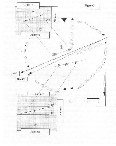
Brophy’s Chart of the 16,500 BC and 4,940 BC Alignments
22
2. The Subterranean Structures and the Cosmological Meaning
We have already observed that the Nabta Playa site is a
three
dimensional structure, having subterranean layers or levels. These archaeology could not interpret along the lines of its usual, worn-out “tombs and religion” paradigm, and after digging around them hoping to find “bones and grave goods” but failing to do so, simply dubbed these subterranean megaliths as “complex structures.”
23
These are more accurately “sculptures
carved onto the bedrock
8 to 12 feet beneath the surface.”
24
One of these, dubbed by archaeologists Complex Structure A, contains a surface carving of an analogue of the entire Milky Way Galaxy.
25
That’s not all:
The Sagittarius Dwarf Galaxy, a recently discovered small satellite galaxy to our Milky Way may even be represented in the correct place on the sculpture as are the galactic spiral arms. In fact recent astrophysical analysis of the shape and location of the Sagittarius Dwarf Galaxy indicates that it more closely fits the Nabta sculpture representation than the Electronic Sky drawing… in
Monthly Notices of the Royal Astronomical Society.
26