Stockwin's Maritime Miscellany (12 page)
Read Stockwin's Maritime Miscellany Online
Authors: Julian Stockwin

In large sea battles, frigates were stationed to one side out of the gun-smoke to act as ‘repeaters’, passing on signals from the commander-in-chief. Both sides agreed not to fire on these frigates
.
Flags, however, did have drawbacks. If the wind blew them end-on they could not be read; battle-haze often hid them; they were not visible at night; and only a limited number of flags can be flown at one time, so complex signals were impossible
.
Captains were often thus forced to fall back on the tactic of ‘speak the ship’ – foam up alongside and bellow at each other with a speaking trumpet
.
A SQUARE MEAL – substantial repast.
DERIVATION
: sailors ate their food off square wooden plates with a raised edge called a fiddle. This design was to stop food falling off the plate and to set a limit on the amount of food taken. If a seaman overfilled the plate he was said to be ‘on the fiddle’ and could be punished.
 F
FLOWERS FROM THE ‘END OF THE WORLD’
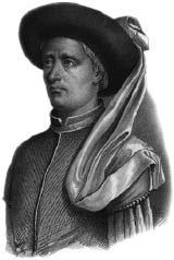
Henry the Navigator was the man chiefly responsible for Portugal’s heroic age of exploration between the 1430s and the 1550s, but he never actually set sail on any of these great voyages of discovery. Born in 1394 he was the third child of King John I of Portugal. Contemporary records describe him as a person who did not indulge in luxuries, was softly spoken and never allowed a poor person to leave his presence empty-handed.
Henry established a maritime think-tank and gathered the great minds of the day around him. Under his patronage a number of expeditions sailed south to extend the boundaries of the known world. But in the fifteenth century the red sandstone cliffs of Cape Bojador off the west coast of Africa was seen as the point beyond which there was no return. There the seas crashed into the cliffs in constant fury, fearsome waterspouts erupted and dust storms howled off the cliff tops.
According to popular belief, past the cape lay the end of the world, the Green Sea of Darkness, an area where the sun was so close to the Earth that a person’s skin would turn black, the sea boiled, ships caught fire and monsters lurked waiting to smash the ships and eat the sailors. Henry did not believe any such nonsense, but up until 1433 he could entice no seaman to pass Cape Bojador.
Henry’s persistence did finally pay off. He persuaded Gil Eannes, who had turned back after starting a previous voyage, to make a second attempt. This time Eannes reached the cape, skirted around its deadly hazards and then worked his way inshore until he reached the coast, where he landed and picked flowers. When he returned he announced that beyond Cape Bojador there was in fact no Green Sea of Darkness.
Prince Henry died in 1460, having transformed European expansion and trade from the old land routes to new sea routes in the Southern Ocean. By the end of the sixteenth century Lisbon was the European hub of commerce with the Far East.
 Henry the Navigator
.
M
ERCATOR, MAPS AND MARS
Geradus Mercator was a Flemish cartographer born in 1512 at the dawn of the Age of Discovery. He invented a revolutionary way of projecting maps on to paper which enabled mariners to steer a course over long distances by plotting straight lines without continual adjustment of compass readings.
In 1544 Mercator was put in jail for seven months on trumped-up charges of heresy, probably because the Dutch had ambitions to be a world sea power and were anxious to prevent such maps getting into the hands of others.
Mercator later moved to the German Duchy of Cleves, and in 1569 he used his radical projection plan to construct a map of the world. Although his map was to change the future of cartography and navigation profoundly, initially it received scant attention. However, this was the age of Queen Elizabeth, and rival nations were groping for the navigational key to an ocean empire. Seers like John Dee were sent over to bring back such secrets and they duly returned with instruments and the new charts.
At the time these were too advanced for the ordinary mariner, and it was not until some years after Mercator’s death in 1594 that his projection was accepted for navigational use at sea on any significant scale. By about 1640 it was widespread and this continues to be the case on today’s navigation charts. And in the twenty-first century it is Mercator projections that NASA are using to map Mars!
Mercator’s legacy did not stop there. He was one of the first mapmakers to cut up maps and bind them inside boards, later coining the term ‘atlas’ to refer to such collections.
 Geradus Mercator
.
I
CY GRAIL
The search for the Northwest Passage, a shorter shipping route from Europe to the wealth of the Orient via the ice-bound waters of the Arctic, began in the late fifteenth century with the voyages of the father and son explorers, John and Sebastian Cabot.
Finding this fabled passage preoccupied the Elizabethan imagination. Among the heroic maritime explorers of the age who sought to connect the Atlantic and Pacific Oceans were Martin Frobisher, Humphrey Gilbert and John Davis.
Gilbert, who wrote a treatise on the Northwest Passage in 1566 that inspired many later explorers, disappeared off the coast of Labrador on 9 September 1583. From the deck of
Squirrel
he hailed another expedition ship,
Golden Hinde
, calling across to them in encouragement, ‘We are as near to heaven by sea as by land.’ Later that evening somewhere in the darkness his ship was swallowed up by the sea, with the loss of all souls.
Henry Hudson made four momentous voyages in search of the Northwest Passage. On 22 June 1611, during his last voyage, he suffered a mutiny aboard. He and seven of his crew, plus his young son, were set adrift in a small boat and died in the Arctic bay to which his name has been given.
Interest then waned for many years. In 1744 the British government offered a prize of £20,000 (over £3 million today) to the first person to discover the Northwest Passage. The search was on again in earnest and a series of naval expeditions, including James Cook’s third great voyage of exploration, were mounted. Much of the Arctic area was charted but the Northwest Passage remained elusive. The last official naval expedition was the famous voyage of Sir John Franklin, who sailed into Lancaster Sound in 1845 in HMS
Erebus
and HMS
Terror
and was never seen again.
Over the course of the next decade over 30 search parties were sent out to solve the mystery of Franklin’s disappearance. This was largely due to the persistence of his wife Jane, who herself sponsored four expeditions, including the final one in 1857 led by Captain Leopold McClintock. One of the searchers in the McClintock expedition, Robert McClure, found sad relics of Franklin’s expedition. He also gained official recognition for the proof of the reality of the Northwest Passage.
The truth of the Franklin tragedy has now emerged. During the winter of 1846–7 Franklin’s two ships became trapped in thick ice. Franklin died in June 1847 and by April of the next year 21 more had perished in the bitter conditions from a combination of starvation, scurvy and lead poisoning (from their canned food). They probably resorted to cannibalism as their situation became ever more desperate.
Ironically, more people died looking for Franklin than perished on his final voyage.
The fabled passage was not successfully navigated until the twentieth century, when Roald Amundsen completed a full transit by sea in his tiny vessel
Gjoa
in 1906.
As the Arctic ice melts with global warming the Northwest Passage may yet turn out to be the great trade route connecting two oceans that maritime explorers sought for four centuries.
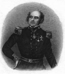 John Franklin
.
PRESS ON – push ahead with all speed, regardless of comfort.
DERIVATION
: at sea a captain would often crowd on as much canvas as conditions allowed in order to complete a voyage in the shortest possible time. Thus rigged, a ship would be said to be ‘under a press of sail’, her bow pushed into the waves, resulting in a wet trip.
THE MAN WHO PUT AUSTRALIA ON THE MAP
If you look at a map of Australia you are looking at the memorial of the great navigator and cartographer Matthew Flinders. In the course of his work he survived shipwreck and disaster and was imprisoned for many years as a spy. Although his life was short, his achievements made him one of the most important naval explorers of his time.
Flinders circumnavigated the lonely continent in 1801–03. He had previously charted Tasmania with George Bass in 1798–9, demonstrating it was an island separated from the mainland by a strait of water. Flinders proved that the east coast, charted by James Cook in 1770, was part of the same land mass as the west, which had been surveyed by the Dutch navigators during the seventeenth century.
As he was returning to England in 1803, not knowing that England was at war with France again, he put into Mauritius for repairs to his ship
Cumberland
. The French governor believed he was a British spy and he was incarcerated there for over six years. In 1804, detained under close confinement, he drew the first map of Australia. Towards the end of his time in Mauritius he wrote
A Biographical Tribute to the Memory of Trim
, the charming story of the seafaring cat who accompanied him during his circumnavigation of Australia.