To Walk Far, Carry Less : Camino de Santiago (14 page)
Read To Walk Far, Carry Less : Camino de Santiago Online
Authors: Jean-Christie Ashmore
Tags: #Backing, #Camino

Like safety pins, a short length of string or cord can solve many problems. I’ve used a thin cord to securely attach the traditional pilgrim shell to the outside of my backpack. I’ve used string to tie still-wet socks to the outside of my backpack, so they can dry while I hike. The string can also be used as a mini-clothesline.
* * *
Once your backpack’s contents are planned out, it’s important not to let all your hard work go to waste by loading yourself down with books and maps. These important items can also be trimmed down for a lightweight backpack, as you’ll see in the next chapter.
A guidebook provides details for a Camino route. It lists the distances between cities, towns, and villages and tells you when to turn right or left and when to continue straight ahead (which is helpful when trail markers are scarce or unclear). It also lets you know what the terrain is like; where to sleep and eat; and where to find an ATM, transportation, and help. A guidebook also offers information about local sights and shares stories about a place and its people. Sometimes a map is included in the guidebook, although it’s usually just a rough sketch. That’s when a route map can come in handy.
A route map provides a detailed visual orientation to supplement your guidebook. It shows the context of where you are in relation to other places. So, for example, you might see a village a few kilometers off the trail where there might be a bar-café. A detailed map shows where to leave the trail to get to the village—and maybe even how you could pick up the trail again without backtracking. Or a map might show a lake near the trail where you could eat lunch and have a siesta.
Lightweight Notes
How to Eliminate Paper Weight
Take only essential guidebook pages.
Tear out extraneous information like gear lists, descriptions of flora and fauna, and historical background.
Remove the book’s front and back covers.
Trim the page margins.
Throw away guidebook pages and maps after using them, or mail them home.
(Your guidebook’s weight should diminish every day.)
Cut maps to only cover the areas you’re walking through.
As mentioned before, on my last journey
I saved 494 grams (about 1 pound, 1 ounce)
just by cutting the extra paper out of guidebooks and off maps.
A detailed route map can also help you find an alternate route when there’s a problem on the trail—like a bridge destroyed by a recent storm. Or the map might help you determine the direction to go when roadwork removes all the Camino trail markers at an intersection. Sometimes Mother Nature changes the trail markers too: I once arrived at a crossroads to find an old tree had collapsed; the painted trail marker was lying on the ground on a piece of bark. Since the guidebook was not clear on which direction to head (as sometimes happens), the route map helped me to figure out which trail to take, and I soon found another trail marker confirming I was on the right path.
Packing Tips
The essential guides for the Camino routes are the guidebook and the trail markers. But a detailed route map can be a helpful supplement for your journey. If a map is available for the route you plan to take (not all routes have detailed maps available), I’d recommend taking one with you.
It’s important to keep your printed map and guidebook pages dry. The lightest choice for protecting them is a clear plastic ziplock bag. A drawback to using digital guidebooks or maps is that the display device (like a mobile phone, or an iPad or other tablet computer) could get wet—it might be raining hard just at the moment when you need to pull out your digital map to know whether you should turn right or left at a crossroads. Adequate shelter is not always available, like on the open plains or in a pine forest where raindrops fall easily through the skinny branches, and a digital device might become permanently damaged if it gets wet.
There are Camino guidebooks in many languages. For English speakers, a great place to look for guidebooks is the Confraternity of Saint James in London. They publish guidebooks for all the routes and sell them in their bookshop online at
www.csj.org.uk
(see Resources for more guidebook-buying options).
A guidebook will tell you what maps you need, if any. One guidebook for the Vézelay route, for example, includes detailed maps along with the text describing the route in detail—so there’s no need to supplement that guidebook with another route map.
Every Camino route is different, with varying degrees of organized infrastructure such as places to stay within a reasonable walking distance or general help and support for pilgrims on their way to Santiago de Compostela. Usually the most up-to-date guidebooks and maps are for the most popular Camino routes, such as the Camino Francés (by far the most popular) or the Le Puy route in France.
On the Camino
If you’re walking through both France and Spain, from the location of your starting point in France you can mail yourself the Spanish guidebook (and map, if you have one) to a town or city near where you’ll cross the border—such as to St. Jean Pied-de-Port in France, which is the beginning of the Camino Francés route. That might be safer than mailing it from your home outside of Europe using the Poste Restante (general delivery) method that’s been used by travelers for years (unfortunately, recent security concerns have made that option a bit uncertain). The local French post office where you mail the package from can help you with the postal code and the best way to write your name and address.
If you’d like to investigate digital guidebooks or apps that are specific to the Camino, here are a few places to start your search.
Cicerone:
This U.K. publisher sells English-language Camino guidebooks in both ebook and print formats. For example, you can buy ebooks for the Le Puy route (title:
The Way of Saint James—France
), the Vía de la Plata route (title:
Vía de la Plata
), and the Camino Francés route (title:
The Way of Saint James
). Visit their website,
www.cicerone.co.uk
, for more information on compatible digital devices and computer applications for their ebooks.
Apple iTunes App Store:
You can access Apple’s App Store using your Apple device or iTunes on your computer. Search on the term “Camino” to bring up the latest apps that relate to the Camino de Santiago. You’ll need an Apple device, such as an iPad, iPhone, or iPod Touch, to use the apps.
Android Market:
Google’s operating system called Android is used on numerous digital devices; the Android app store can be found at
https://market.android.com
. Again, do a “Camino” search to find out if any relevant apps are available.
Amazon’s App Store:
Amazon also sells apps for devices that use Google’s Android operating system. Go to
www.amazon.com
and look for the link to their app store.
Confraternity of Saint James:
The organization that exists to help Camino pilgrims also provides digital access to some Camino guides (see
www.csj.org.uk
).
Gear Guide
Some Camino apps require an internet connection or 3G access (or later technology, starting with 4G). These connections are often not available on the mostly rural Camino trails. And if you do find access through mobile-phone towers (3G or 4G+), the data usage on your device could be expensive, so it’s a good idea to read the specifics on how a particular app works.
Consider taking a map of Spain, France, or western Europe to use for general orientation and trip planning.
For example, here’s how I’ve used these maps:
- After arriving in Santiago de Compostela, a map of western Europe helped me plan a trip through Spain, France, and Switzerland to visit friends.
- A map of France helped me plan travel from Paris to Le Puy-en-Velay to start the Le Puy route—and helped me get back to Paris after finishing just before the Spanish border in Saint-Jean-Pied-de-Port.
- A map of western Europe helped me organize a plan B after a foot injury stopped my Camino journey.
- General orientation maps also help me plan tourist-type visits before starting a Camino journey—a great way to get over jet lag when you first arrive in Europe.
To save even more weight, you could always buy a general orientation map
after
you finish your Camino walk, or toss out the map at the trailhead before you start walking.
It’s not necessarily a huge weight burden, though: my western Europe map weighs 42 grams (1.5 ounces). That’s little weight to carry in exchange for having a helpful resource at hand.
To stay overnight in pilgrim-only accommodations, you need a pilgrim’s credential, called a
credencial del peregrino
in Spanish and a
créanciale du pèlerin
in French. It’s a type of pilgrim’s passport that authorizes you to use pilgrims’ facilities.
This little booklet is stamped and dated every night, usually by the caretaker of the pilgrims’ refuge. Many hotels, inns, and bed-and-breakfast accommodations will also stamp the credential for you. It’s a good way to remember where you stayed each night, and fun to look at after you’ve completed your journey.
When you arrive in Santiago de Compostela, you can present your credential at the Pilgrims’ Office next to the cathedral as proof of your journey. They’ll translate your name into Latin and write it on a
Compostela,
a document that certifies your completed journey. This is a centuries-old tradition. To receive a
Compostela,
you must walk at least the last 100 kilometers (about 62 miles) to the city of Santiago de Compostela.
Several years ago the Pilgrims’ Office started asking pilgrims to get their credential stamped twice per day if they begin their journey in Galicia—the autonomous region in northwest Spain that is home to the city of Santiago de Compostela. They hoped that this requirement would discourage those who “cheat” to get the
Compostela
—by driving a car or taking a bus or train instead of walking the last 100 kilometers to Santiago (the minimum requirement to get the
Compostela
when traveling by foot—check with the Pilgrims’ Office for the requirements when cycling or riding a horse or donkey to Santiago). So if you plan to start in Galicia and would like to receive the pilgrims’
Compostela,
get one stamp at your accommodation, and another stamp from a church, town hall, or the local police along the way—every day. If you start your pilgrimage journey outside of Galicia, only one stamp per day is required. (Visit the Pilgrims’ Office website,
www.peregrinossantiago.es/eng/
, to see if this is still their policy by the time you read this information.)
The guidebook for the route you’ll walk is the best source of information on where to obtain your pilgrim’s credential. You might get it at a Camino pilgrims’ association office, or at a church or cathedral or their affiliated offices. Allow plenty of time if you order a credential from a pilgrims’ association before leaving home—some can take as long as a month to arrive. You can find Camino associations and their website links through the Confraternity of Saint James.
Getting Your Pilgrim’s Credential in Europe
I prefer to get my pilgrim’s credential at a pilgrims’ association office in France or Spain, where I can also get the latest information for the route. For example, at these offices I’ve been warned to delay my journey for a day or two due to expected severe weather. I’ve also been given a hand-sketched map for a recently changed section of the trail and have been told to use the paved road instead of going through the vineyards stretch of the trail if the rain doesn’t let up (making the vineyards muddy and walking difficult). The pilgrims’ offices also have the latest information on recently closed refuges and can tell you where there are newly opened refuges. This kind of up-to-date information is not found in guidebooks, so it’s a good idea to at least occasionally stop by a pilgrims’ association office along the way.
* * *
You need not be Roman Catholic to obtain a pilgrim’s credential. People of any faith, or no faith, walk the Camino. The great tradition is that the Camino is open to all.
Chapter 12 Backpack Features to Consider: How to Avoid a Heavy Backpack Before You Start Packing
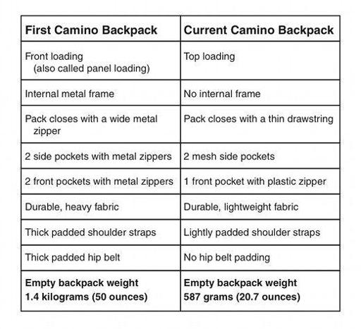
Heavy loads require a heavy backpack to support that weight: this means a sturdy frame, substantial hip belt, and thick padded shoulder straps.
A lighter load offers the opportunity to use a lightweight backpack: no frame, slim hip belt, and lightly padded shoulder straps.
In other words, the weight of the backpack itself plays a role in creating a lightweight backpack.
Lightweight Notes
Caution
If your backpack contents weigh much more than about 11–12 percent of your body weight, you’ll likely need a backpack with more structure and features to support that load. Carrying a heavy load in a backpack that has minimal features will put too much stress on your body.
Note the difference in features and weight between my first Camino backpack and the one I currently use. Both have about the same volume capacity, but the difference in weight is nearly a kilogram (about 2 pounds).