AWOL on the Appalachian Trail (34 page)
Read AWOL on the Appalachian Trail Online
Authors: David Miller

I leave camp and hike alone, quickly reaching Rainbow Ledges, a rocky cliff from where I get one last look at Katahdin before the trail submerges into the woods for the next six miles. Abol Bridge marks the end of the 100-Mile Wilderness. From the bridge, I pause to take in the new perspective of Katahdin. This is the postcard view, the unobstructed front, the broadside view of the mountain. I can see every crag and ridge, all the way down to where the mountain merges with the humble flat of trees before it.
There is a camp store near the bridge. I stop in to get my fill of food before tackling the remainder of the day. I see a newspaper with an update on Hurricane Isabel, an Atlantic storm that Juli had told me about when I was in Monson. Five days ago, the storm was a latent threat far out in the Caribbean. The storm is more worrisome now since it has yet to turn northerly. Like most Atlantic storms, it is potentially a threat to the entire East Coast, which could affect my home in Florida, my family's flight to Maine, or the weather here when I climb Katahdin two days from now. Ken, Marcia, and Kiwi arrive at the store while I am loitering, and we all proceed into Baxter State Park together.
There is a sign-up sheet at the park entry to ration the limited camping and shelter space within the park. A large sign is above the sign-up sheet so it will not escape our attention. Kiwi and I get our picture taken in front of the sign, conferring our own meaning upon the notice that reads, "Important: A.T. Thru-Hikers."
The trail is scenic within the park, for much of the way running parallel to the Penobscot River, the same river I crossed on the Abol Bridge. But my excitement wanes. The rail alongside the river is deeply rutted and rocky. My feet feel bruised, and I have seven more miles to walk, on top of fourteen that I've walked already. Our circuitous route through the park is actually taking us further away from Mount Katahdin. It looked so close from the bridge. The trail turns away from the Penobscot and follows a tributary upstream. The stream that we now follow, the Nesowadnehunk, is a wide stream cascading over massive boulders. I no longer appreciate the scenery; I just want my day to end. The threat of Hurricane Isabel weighs on me, and worries darken my mood.
40
We come to a spot where a huge slab of bedrock slopes from our shoreline out into the stream, funneling the water into a casca
de near the far side. Kiwi and I walk out and sit on the slab, essentially in midstream of this thirty-foot-wide creek. Other hikers are sliding with the cascade down the rock face, splashing into a pool of water below. Kiwi gives me half of a honeybun he purchased back at the Abol Bridge camp store, trying to cheer me up. Kiwi has been a great hiking partner, always positive, considerate, and sharing. I part with Kiwi at Katahdin Stream Campground. He will stay here tonight and conclude his hike tomorrow. He promises to look me up in Millinocket.
Luckily for me, Bob and Gloria Nicholson are descending from Katahdin just as I arrive, and they offer me a ride to town. They are from Maine and have driven out to hike up the mountain today. Their son thru-hiked in 2000.
41
They give me a tour of the town of Millinocket, which is more spread out than most trail towns. I stay at the AT Lodge, a bunkroom on Main Street.
I call Juli and we discuss our plans for her arrival in two days. She tells me that if it looks like the weather will change for the worse, I should go ahead and hike Katahdin by myself. I have been fortunate to have had excellent weather over the past week, and for the moment, it looks as if favorable weather will continue. Also, my day was exhausting. In the eight days since leaving Caratunk, I have averaged over eighteen miles per day. I am ready for two days of rest.
On my first day in Millinocket, I do laundry and eat well, like I've always done in town while on this hike. I visit the grocery store, but I really don't need any supplies. My last day on Mount Katahdin will be a day hike. I have no plans to make, and I miss the responsibility. I meet Kiwi at the Appalachian Trail Cafe just as he arrives in town. We sit for dinner (Kiwi orders fish and chips), and he tells me of his climb up Katahdin in perfect weather. Palpable excitement makes my retired friend seem like a schoolboy.
I spend my second day milling about town, waiting impatiently. The weather is overcast, and there are intermittent showers. I worry that I have missed the opportunity to end my hike on a clear day. Kiwi has headed home, but Ken and Marcia are still in town when my family arrives, and I am happy that they get to meet them. My youngest daughter, Lynn, is five years old, Rene is eight, and Jessie is nine. Juli's brothers have also made the trip. Mark is older than Juli, and Mike is two years younger.
Juli, Jessie, and Mike will hike the last five miles of the trail with me. We are awake and on the road before sunrise, making the twenty-mile drive to Baxter State Park. Nearing the park, the strip of road cuts a channel through the trees. A bear runs across the road. We can see Katahdin, perfectly centered in the swath cleared of trees. The side of the peak to our right is tinted gold with sunlight. The top o the mountain is the first piece of land in the United States touched by the morning sun.
At Katahdin Stream Campground, the weather is ideal, cloudless and about fifty degrees. We start at 7:15 a.m. The trail is densely wooded, "like a jungle," Jessie says. The footpath is moderately inclined uphill, somewhat smooth with only scattered rocks. Birch trees have dropped a coating of brown and yellow leaves on the trail. We cross Katahdin Stream and Falls on a footbridge. After a couple of miles, Jessie begins to tire, which is troubling because the most difficult climbing is still ahead. Mike volunteers to turn back, but Jessie is not yet ready to give up.
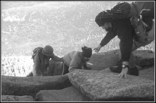
As we progress, the trail gets steeper, and the boulders get larger. One section reminds me of Mahoosuc Notch; there are huge boulders gathered in a depression, mixed in with trees. We pick our way through and move higher. Jessie perks up with the change of terrain. She likes using her hands and wriggling through the rocks. Once above timberline, we feel a brisk, cold wind. I can see an unbounded view of the Maine wilderness. Boulders are steep and precarious, especially with the wind. Rebar handholds are implanted into a few of them. Jessie hugs tight to the mountain when the wind gusts. Again, we stop to assess the wisdom of continuing with her. She's never done anything like this before. Getting down may be as difficult as going up. We are progressing very slowly. Most of the other hikers headed to the top of Katahdin via the AT started earlier or have already passed us. We proceed. Jessie is game, and there are three of us to help her. Someone nearly always has a hand on her in this stretch, supporting her from below or pulling from above. There is a solid mile of hand-over-hand climbing.

Juli, Jessie, and Awol headed up Katahdin.
Thru-hiking has been more of a challenge than I expected. Always, there were exhausting climbs and bone-jarring descents. The amount of elevation gain and loss on the AT is equivalent to climbing up and down Mount Everest sixteen times. The terrain was a greater impediment than I would have anticipated. Slippery roots and foot-bruising rocks slowed me more than any other factor. Rain, cold weather, and hot days would compound obstacles and make work of the easiest days. Countless days I struggled into camp with burning feet, aching knees, and soaking wet clothes. I won't miss stuffing blistered feet into stiff, muddy trail shoes.
But the pleasure and contentment I felt on the trail far outweighed the adversity. Even on the most exasperating days, I never considered quitting. The most uncertainty I had about continuing was when I had injuries: a sore knee, an infected foot, and a sprained ankle. Those injuries tested my resolve, but ultimately reinforced my desire to continue. Possibly it was a motivational advantage for me to be attempting a thru-hike in my particular circumstance: not young, not single, not retired, and not rich. If I left the trail, I couldn't try again next year. It was a one-shot deal. I am lucky to have experienced it all--the awe of seeing spectacular landscapes, the excitement of encounters with wildlife, and the invigoration of a physical lifestyle. It was always a treat to descend into one of the tiny towns the trail goes through, to get cleaned up, and emerge replenished.
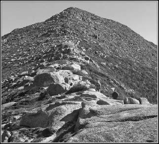
Beyond the worst of the bouldering on Katahdin, we see a summit ahead, a pointed mound of rock piercing the unclouded blue sky. The trail follows a ridge up to this summit, a ridge like the edge of a pyramid, studded with boulders. The vieoule fantastic. I take photos from atop a boulder, thinking how the view before me is perfectly composed. Then I move forward fifty yards and have the same thought again. Hikers tend to speak of the mountain for its symbolic value as an endpoint of the Appalachian Trail, and not enough is said about the mountain's autonomous appeal. Mount Katahdin is the most picturesque mountain on the trail. It presents itself wonderfully from a distance. The views from the trail on the mountain itself are enthrallingly diverse. The landscape before me now is beautiful in its simplicity, grandeur, and immutability. It will be equally beautiful in the winter and in the summer. It will look the same next year and one hundred years from now.

The trail up Hunt Spur. Mike and Jessie are in the foreground.
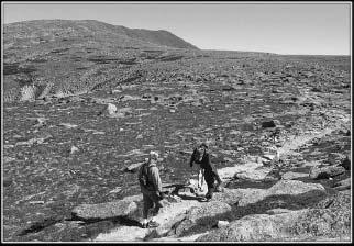
For me, hiking up this mountain seems nearly effortless. Perhaps it is because I am traveling at the pace of my group, the distracting beauty, or the excitement of finishing. On reaching the peak of our pyramid, we see that it is only the shoulder of the mountain. There is a nearly level expanse before us, with entirely new terrain, similar to a glacial plateau. This feature of Katahdin is called the tableland. The surface is peppered with rocks, but they are almost uniformly flat, low to the ground, and spotted with olive-green lichen. Alpine shrubbery coats the ground where rocks do not protrude. The shrubbery is as dense and as tight to the ground as grass, but it has a rusty brown color.

Mike, Juli, and Jessie crossing Katahdin tableland.
We see hikers who passed us earlier in the day, now on their way down. We yell congratulations over the howl of the wind. I recognize Dutch, Chief, and Dreamwalker. They are cheerful, talkative, and emotional. More than one of the hikers has red, watery eyes from a tearfully joyful summit. So much has happened over the past 2,172 miles. I have come through fourteen states, seen twenty-one bears, lost eight toenails, and gone through six pairs of shoes.
The work is behind us. The trail across the tableland is an easy walk, gently uphill. I'm proud of Jessie for climbing the mountain with me. Nearing the peak, the wind dies down. There are a hundred yards of trail up one last mound of rock to the mile-high summit. Hikers are taking celebratory photos behind the simple wood sign on top with a backdrop of blue skies: "KATAHDIN--Northern terminus of the Appalachian Trail." Even though the end has been on my mind for the past few weeks, finishing seems abrupt. This is it: 146 days of unforgettable scenery, seemingly endless miles of trail, rain, pain, and friendships. It's over.
