In the Footsteps of Lewis and Clark (12 page)
Read In the Footsteps of Lewis and Clark Online
Authors: Wallace G. Lewis

Fig 2.4
Gates of the Mountains on the Missouri River, north of Helena, Montana. Meriwether Lewis noted “a dark and gloomy aspect” to the narrow six-mile stretch of canyon as he passed through it on July 19, 1805. Much of the effect today has been eliminated by water backing up from Holter Dam. Photo by Donnie Sexton. Courtesy, Travel Montana.

It was William Clark's turn to scout ahead with an overland party. South of Townsend and Canyon Ferry Reservoir, which now inundates this portion of the river, Clark and his party reached the area where the Gallatin River, coming from the east, helps form the main stem of the Missouri and the very sinuous Madison and Jefferson rivers join together a few miles north of Interstate 90 and the town of Three Forks. Clark's men also checked out part of the canyon through which the Jefferson River entered the valley and passed close to the site of Lewis and Clark Caverns State Park before returning to join the main party, whose river journey had proceeded along U.S. Highway 287 to Toston, Montana, and then through another canyon to the Three Forks of the Missouri.
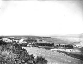
Fig 2.5
A view of the Three Forks (headwaters) of the Missouri River, looking south. DeCamp was the photographer who accompanied Olin D. Wheeler on his search for Lewis and Clark campsites through the Lolo country. Photo by R. E. DeCamp, Courtesy, Montana Historical Society Research Center, Helena.
Today, Interstate 90 climbs out of the valley about fifteen miles west of the town of Three Forks before dropping down to the Jefferson River Valley, at the foot of which is the town of Whitehall. U.S. 87 and Montana Highway 2, however, remain on the water grade of the Jefferson River canyon and on the expedition's original route. From near Whitehall, the group continued in a southwesterly direction to Twin Bridges, Montana, close to where the Beaverhead, Ruby, and Big Hole rivers come together to form the Jefferson. (Lewis and Clark named the latter two the “Philanthropy” and “Wisdom” rivers, respectively.) A dozen miles south of Twin Bridges they came upon
Beaverhead Rock, whichâas noted earlierâSacagawea recognized, thereby assuring them that they were on the right track. They were moving up one of several valleys in southwestern Montana that run generally north from the Continental Divide. Yet the Divide was also directly west because the crest of the Bitterroot Mountain range, along which the Divide runs for some distance, turns dramatically to the northwest. From the Great Falls, the elevation had risen 2,000 feet by the time the explorers reached Beaverhead Rock. The streams were becoming narrower and shallower, and the two captains were convinced that they would soon arrive at the point where the Missouri River's main tributary rose on the Divide itself. Still, there had been no sign of the Shoshone Indians, Sacagawea's people, from whom they desperately hoped to obtain horses on which to cross the last range of the Rockies.
On August 9 Lewis, accompanied by four menâincluding the hunter Drouillardâwalked on ahead of the main party, which was toiling up the Beaverhead River south of Dillon, Montana, to locate a band of the Shoshone. Lewis named the two imposing rocks that marked the entrance to the Beaverhead River canyon just south of Dillon “Rattlesnake Cliffs.” The route through the canyon is now followed by I-15. At the juncture where the Red Rock River joined with Horse Prairie Creek to form the Beaverhead, the men turned west through the broad Horse Prairie Valley, where they spotted Indians who quickly retreated into the mountains. Lewis and his men followed, climbing to the summit of Gibbons Pass on the Continental Divide. It was not actually the “most distant” tributary of the Missouri River but tiny Trail Creek, which leads almost to the summit, that gave the men an opportunity to finally “straddle” the mighty Missouri. From the largely bare crest of the Divide, they gazed westward into Idaho.
The Missouri segment of the outward journey had ended, but any expectations that the expedition would be able to easily slip down the Pacific slope to the Columbia River on tributaries were quickly dashed. In his entry for August 12, 1805, Lewis reported that he had “discovered immence ranges of high mountains still to the West of us with their tops partially covered with snow.” [V, 74] There would be no easy portage to the Columbia. It became even more urgent to obtain an adequate supply of mounts. Lewis and his men soon encountered a Shoshone band and returned with them to the forks of the Beaverhead, where Clark and the main party arrived to set up Camp Fortunate. After the captains had parleyed with the Shoshone and their chief, Cameahwait (Sacagawea's brother), the entire group crossed over Lemhi Pass.
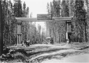
Fig 2.6
Gibbons Pass, where Clark's party crossed the Continental Divide into the Big Hole Valley of Montana en route to Camp Fortunate and the Yellowstone River in late summer 1806. The (undated) photograph was taken not far from Lost Trail Pass, which the expedition had taken on the outward journey, just before meeting with Flathead (Salish) Indians. Photographer unidentified. Courtesy, Montana Historical Society Research Center, Helena.
The Shoshone had been among the first Indians in the region that is now Idaho, Montana, and Wyoming to obtain horses from the Spanish Southwest in the mid-eighteenth century. This gave them a major advantage in hunting buffalo and in warfare, and for decades Shoshone bands dominated the plains region north and south of the upper Missouri River. But their power was eventually countered by tribes that possessed firearms. In particular, the Piegan, Blood, and Gros Ventres bands of the Blackfoot Confederacy, which possessed both guns and horses, were effective in pushing back the Shoshone. By
the time Lewis and Clark arrived on the Northern Plains, the Lemhi Shoshone band had been forced into the Bitterroot and Beaverhead mountains of eastern Idaho and western Montana. Without guns, they faced great risk in venturing onto the plains to hunt buffalo. Like the Flathead (Salish) Indians to the north, they had to avoid Blackfoot war and hunting parties and return to the protection of the mountains as quickly as possible. Cameahwait's band, languishing from hunger when the Corps of Discovery arrived, had been about to leave on a hit-and-run attempt to obtain buffalo meat for their village. It is not surprising, then, that Lewis and Clark represented a great opportunity to them. If the Americans would supply the Shoshone with guns and ammunition, Cameahwait's people would have a chance to equalize power in buffalo country.
Now on the Pacific side of the Continental Divide, the expedition had to linger for more than two weeks at the Lemhi Shoshone camp near present-day Salmon, Idaho, to bargain for horses. Clark took a small party to see if the westward-flowing Salmon River would provide a water path to the Columbia, but the canyon walls proved to be steep and treacherous and the rapids far too dangerous to attempt to navigate.
At the beginning of September, members of the Corps of Discovery were forced to move north and re-cross the Bitterroot crest, although they remained on the west side of the Divide. Working their way through heavy timber, they descended from Lost Trail Pass to Ross's Hole in Montana, where they picked up additional horses from a band of Flathead Indians and struck the Bitterroot River (which they dubbed “Clark's River”). With them was a Shoshone called Old Toby, who would guide them westward over the mountains further north by way of the Lolo Trail, a pathway used by Nez Perce and other tribes to cross from the plateau country of Oregon and Washington into the buffalo-hunting regions east of the Rockies. The jumping-off point for the Lolo Trail was at a place Lewis and Clark named Traveler's Rest, down the Bitterroot River past Darby, Hamilton, and Stevensville, Montana. At Traveler's Rest, near the confluence of the Bitterroot River and Lolo Creek (present-day Lolo, Montana), they stopped on September 9, 1805, to prepare to cross a mountain range whose peaks already showed signs of heavy snowfall.
After leaving Traveler's Rest, the explorers began to move west through the narrow valley of Lolo Creek. On September 12, William Clark, with an advance party, encountered hot springs in the vicinity of very large boulders and stony outcroppings. From there to the head of Lolo Creek the trail was often steep or choked with beaver dams or deadfall, but near the summit the terrain opened up as they followed Glade Creek to Packer Meadows, near the point where U.S. Highway 12 crosses Lolo Pass. From this point they could see the higher mountains “Covered with snow.” [V, 203] Their Shoshone guide failed to pick up the Lolo Trail right away, and the expedition followed a path down to Colt-killed Creek (so named because they dined there on a colt after reaching the fork of the Lochsa River). On September 15 the narrowness of the river passage forced them to climb out of the canyon on a steep switchback trail. After several mishaps with horses losing their footing, including one that rolled forty yards down the slope and smashed Clark's writing desk against a tree, the party reached the top of Wendover Ridge and followed it to the main Lolo Trail. From there Clark wrote, “I could observe high ruged mountains in every direction as far as I could See.” [V, 207] They melted snow for drinking water. Game was virtually nonexistent. This set the stage for the Lolo crossing of the mountains in what is now Idaho and the group's descent to the Weippe Prairie, which took another ten days and nearly resulted in starvation.