In the Footsteps of Lewis and Clark (10 page)
Read In the Footsteps of Lewis and Clark Online
Authors: Wallace G. Lewis

From here the river turned to the northwest, between Sioux City, Iowa, and Yankton, South Dakota. On August 23, one of the Field brothers shot the first of many buffalo on which the expedition members would largely subsist as they moved through the high plains. This occurred at the mouth of the Vermillion River near Vermillion in the southeast corner of South Dakota. Another meeting, this time with Yankton Sioux, took place at Calumet Bluff, a whitish outcropping of the chalky Niobrara Formation. [III, 21] The Yanktons listened politely to what would become the standard harangue but indicated that they were interested mostly in assurances of trade in firearms and ammunition. In early September the men passed the mouth of the Niobrara River, which heads far to the west in Wyoming. The captains spent considerable time examining what they took to be an
“antient [
sic
] fortification” similar to the mounds left by an Indian civilization in the Ohio Valley [III, 40, 43n3]. These earth formations have since been determined to have been naturally formed, however. On September 7 they encountered their first prairie dogs near the “tower,” a conical landform in northern Boyd County, Nebraska. An effort to catch one alive resulted in most of the crew spending the better part of a day hauling water to force the animal out of its hole. A week later came the first sighting of pronghorns (often erroneously referred to today as antelope) and, near Chamberlain, South Dakota, the coyote and magpie.
Today, Interstate 90 crosses the Missouri River at Chamberlain. A few miles upstream lay Sioux Pass, a major crossing of the Missouri where three creeks enter on the east bank and at the Big Bend, all now within the Lower Brulé and Crow Creek Indian reservations. [III, 91n2] An American Fur Company post, Fort Lookout, was later built near Sioux Pass. The Big Bend, or “Grand Detour,” is a nearly closed loop in the river. Clark walked across the neck of the hilly peninsula formed by the loop and pronounced the distance to be no more than a mile and a quarter. The keelboat and pirogues following the river, however, were forced to cover a dozen miles to get to the same place. At this point the river flowed more from the west than the north and would continue to do so up to Farmer's Island and the mouth of the Teton (Bad) River opposite Pierre, South Dakota. Today, the difference between the generally flat agricultural lands east of the Missouri and the hilly grass country west of the river is very noticeable. Here, just downstream from the present-day Oahe Dam and Lake, a nearly fatal series of encounters with a band of Teton Sioux occurred.
8
Clark and Lewis were leery of the Teton Sioux (Lakota). Missouri traders operating out of St. Louis had warned them about the risks of encountering Teton bands, which did not want upriver tribes to gain direct access to weapons and other trade goods. By 1804 the western Sioux had begun to use their military power both to expand the region within which they could control access to buffalo herds by other tribes and to maintain a role as middlemen in trade among tribes as well as with whites. By the mid-eighteenth century the Sioux dominated an area that comprised most of North and South Dakota,
portions of eastern Montana and Wyoming, and western Nebraska.
9
Regarding Sioux expansion, President Jefferson had asked Lewis and Clark to take special pains to “make a friendly impression” on the powerful Sioux.
10
So despite their uneasiness, the two captains agreed to hold council with the Brulé Teton band near the mouth of the Bad River, across from the present-site of Pierre, South Dakota.
The first and third days of the expedition's stay with the Brulé were the most dangerous. The officers and men of the Corps of Discovery began by distributing gifts to the Sioux leaders and putting on their now practiced demonstrations of power in full uniform. They seemed not to have been aware of political rivalries within the Brulé band. According to Ronda, two other chiefs shared authority with Black Buffalo, whom the explorers treated as the headman.
11
The initial council was followed by a tense situation involving the boats, exacerbated by the surly behavior of one of the slighted chiefs, called “the Partisan.” His men grabbed hold of the pirogue cable and mast, and the Partisan told Clark that the expedition would not be permitted to advance up the river. For a few moments it looked as if a fight would break out. Clark drew his sword, and Lewis threatened to fire the swivel guns onboard the keelboat. The danger passed, however, and the following day it was Lewis and Clark's turn to be feasted and regaled with demonstrations. But the Partisan was not finished trying to impress the band with his defiance of the expedition. By the third day, the captains had begun to believe the Brulé would do whatever was necessary to turn them back, while many of the Sioux were expressing disappointment at how miserly the gifts had been from an obviously rich store of trade goods and voicing their suspicion that Lewis and Clark intended to trade upriver with tribes that had come to depend on the Sioux for access to European goods. As the crew prepared to leave, the Partisan demanded more gifts, and his followers again seized a boat cable to prevent the expedition's departure. Although Black Buffalo managed to soothe the situation, bitter words were exchanged. The Corps of Discovery left the Brulé band on bad terms, having largely failed to make the requested friendly impression.
12
On October 8, around 150 miles upstream from Pierre, the expedition came upon the first of several deserted Arikara villages near Mobridge, South Dakota. The Arikaras, who lived in earth lodges
in towns protected by ditches and bristling palisades of sharpened poles, derived much of their food supply and tradable goods from agriculture. They tended to cluster at the mouths of tributaries, such as the Cheyenne, Grand, and Moreau rivers flowing into the Missouri from the west. By the time the Corps of Discovery arrived, the once numerous Arikaras had been reduced by smallpox and Sioux raids and been forced to abandon some of their towns in order to consolidate. The Arikara had a curious symbiotic relationship with the Sioux, trading food for horses, buffalo meat and hides, and European manufactured goods, but sometimes the Tetons simply took what they wanted in raids on Arikara villages. The trader Pierre Antoine Tabeau, who lived among the Arikaras, told Lewis and Clark that the Sioux purposely drove buffalo away from the vicinity of Arikara villages so the tribe would remain dependent on the Sioux. As a result, the explorers came to view the situation as a case of Sioux enslavement of their Arikara victims and resolved to establish alliances with upriver tribes that would help free them. The captains were gratified by the Arikaras' willingness to make peace with the Mandans and Hidatsas. Lewis and Clark spent several days in the Arikara village before continuing upstream.
13
It was now mid-October, and the captains hoped to spend the winter at the Mandan Villages, a well-known trading center on the upper Missouri. On the 21st they passed the present-day cities of Bismarck and Mandan, North Dakota, and intersected today's Interstate 94. A week later they were camped opposite the mouth of the Knife River and had arranged a counsel with chiefs from the nearby Mandan and Hidatsa villages. Winter quarters were established as Fort Mandan, a triangular-shaped structure built of cottonwood logs and located a few miles downstream near Washburn, North Dakota, across the Missouri from the village of the Mandan chief Sheheke (Big White). The winter spent among the Mandans and Hidatsas in 1804â1805 gave Clark and Lewis an opportunity to study their cultures. As was the case with the Arikaras, these tribes were largely sedentary and tended extensive fields of squash, beans, and corn. They traded agricultural products with other Indians, who often attended trade fairs at this strategic locationâcentral to the Cree, Assiniboin, Crow, and Cheyenne bands, as well as the Sioux.
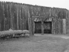
Fig 2.1
Replica of Fort Mandan near Washburn, North Dakota. Here, next to the Missouri River, the Corps of Discovery spent the winter of 1804â1805 among the Mandan and Hidatsa Indians. Courtesy, U.S. Army Center of Military History.

Both the Mandan and the Hidatsa also hunted buffalo, and Hidatsa parties rode as far west as the Great Falls of the Missouri River in northwestern Montana. The captains thus sought information from Hidatsa leaders about the country through which they planned to pass in the spring. They also wanted to conduct diplomacy with both the Native Americans and the Canadian traders in the area around the Mandan Villages. More important, perhaps, they came in contact with Sacagawea, whose husband, Charbonneau, was taken on as an interpreter. Sacagawea was pregnant, and she gave birth to Jean Baptiste, whom Clark would refer to as “Pompy,” on February 11, 1805âa little less than two months before he and his parents left to accompany the Lewis and Clark Expedition to the Pacific Coast and back.
14
On April 7, 1805, a smaller groupâconsisting of the two captains, thirty men including Charbonneau and York, plus Sacagawea and her childâset out from Fort Mandan to seek the headwaters of
the Missouri River and, they hoped, to cross into the Columbia River watershed before winter. The keelboat had departed downstream carrying the members of the original party who were returning to St. Louis. Six dugout canoes and a pair of pirogues would be used for the remainder of the Missouri route. Near the site of Garrison Dam, which today backs up Lake Sakakawea, the Missouri River begins to flow generally from the west. They were still in North Dakota, but further upstream they would move into Montana a few miles west of the confluence of the Yellowstone and Missouri rivers. They were still in the Great Plains, a windswept land of short grass and little rain, and would remain so until midsummer as they followed the Missouri River through western North Dakota and northern Montana.
The Great Plains in this area is a vast extent of glaciated hills, buttes, and shallow coulees, where the only timber is bunched in isolated copses or hugs the bottoms of streams and rivers that cut their way through deep ravines. From the river, Lewis described the North Dakota “upland [as] extremely broken, consisting of high [eroded] nobs as far as the eye can reach on ether side, and entirely destitute of timber” but covered with sagebrush and juniper. Walking along the shore on April 20, Lewis noted within the underbrush of the ubiquitous cottonwood, ash, and box elder trees a variety of rosebushes and currant, gooseberry, and serviceberry shrubs. On the northern fringe of the Dakota badlands the explorers noted sulfurous smoke from fires burning lignite coal seams under the ground. These fires in the Sentinel Butte Formation begin spontaneously and can burn unchecked for years. [IV, 18n5; 21n3].
They soon passed the mouth of the Little Missouri River, which flows out of the Black Hills to the southwest, and proceeded through today's Fort Berthold Indian Reservation. Two weeks out from Fort Mandan the expedition passed the mouth of Little Muddy Creekâwhere Williston, North Dakota, is located todayâand reached the confluence with the Yellowstone, just inside the North Dakota border, on April 25. This river junction became highly important to the upper Missouri fur trade over the next half century. Four trading posts would be built in its vicinity, including the most famous, Fort Union, constructed in 1829. The Yellowstone River, which rises in Yellowstone National Park and flows north to Livingston, Montana,
before crossing the southern part of the state and angling up to the Missouri, provided a return path for part of the expedition in 1806.
15
For the next forty-five days the expedition moved up the Missouri River, westerly through northern Montana. Eventually, the men hoped to make contact with mountain ShoshoneâSacagawea's peopleâso they could obtain horses to cross over to the Columbia River watershed, but here, between the mouths of the White Earth River in the east and the Milk River in the west, they were skirting the southern edge of Assiniboin hunting territory. They did not particularly wish to encounter these Northern Plains Indians. Since the Assiniboin did little to raise horses, they often raided the Hidatsas and Mandans or traded guns for mounts. Like the Sioux, they were jealous of their middleman trading status. Clark and Lewis regarded them as victimizing the Mandans, just as they saw the Tetons as victimizing the Arikara. Although Clark came across signs of recent Indian encampments while walking along the river's bank in eastern Montana, no actual encounter with the Assiniboins took place.