Native Seattle (41 page)

85
Beaver
stuqáxW (lit. ‘dammer’)
This second hill is associated both with the story of the winds, described above, and a story about beavers, given below. Local Indian people have maintained the memory of these hills and their stories despite dramatic changes to the landscape. Also known locally as Poverty Hill, the site has recently been preserved; eventually, interpretive signs and restored native plantings will highlight the valley's rich history and ecology.
86
Little North Wind
stóótooblu
This was a small rock on the west side of the river above 84 and downhill from 85. It was usually submerged, but during low tide it was out of the water. This tidal fluctuation mimics that portion of the myth in which North Wind kept setting his daughter by the river. Every time he did so, the water would rise because her icy earrings would melt.
35
87
Caused to Be Burnt or Blackened
sQWul7ads
The name of this place refers to dark striations on the hill. In the epic story associated with this region, Raven, the slave of North Wind, perched above South Wind's grandmother, whose house was on this stone mountain, and defecated down on her. The paintlike marks on the hillside represented her face covered with the filth of Raven and her own frozen tears.
This hill and Beaver (85) also feature in a story about a battle between Beaver and five brothers, one of them imbued with Thunder power, which split a single eminence into these two hills. Indigenous people also claimed that splashing a canoe paddle in the river here or pouring water against the hillside would bring rain.
Today, the north end of the hill has been quarried away and replaced with an office park, while a new housing development covers its southern slope and Highway 599 separates the hill from the river. Muckleshoot elder Bena Williams told an interviewer that “when they started having a quarry there, then I don't think anybody goes there anymore.”
36
88
Unclean Rock
squlééls
Described as ‘unclean’ in the sense of impure or bad rather than simply unwashed, this location just a hundred yards upstream from Beaver (85) is almost certainly connected to the story of the winds and most likely refers to the befouling that South Wind's grandmother was forced to endure at the hands of the ‘meanie’ North Wind and his birds.
89
Inside Place
dxWduW
The region farther upstream, away from the open saltwater, was known as “inside” for its location inland off Puget Sound. This word is the base of the term “Duwamish.” The valley where the Black, Cedar, and White-Green rivers came together to form the Duwamish was a center of indigenous settlement. There were towns here named Meeting of the Rivers, Crags, Little Cedar River, and Confluence, and the area also became an important refuge for local Native people during Seattle's urban development. Today, only the Green River flows through this area, becoming the Duwamish below the former confluence with the Black, which disappeared with the lowering of Lake Washington in 1916. (The Cedar was rerouted north to Lake Washington, and the White was sent south to Tacoma.)
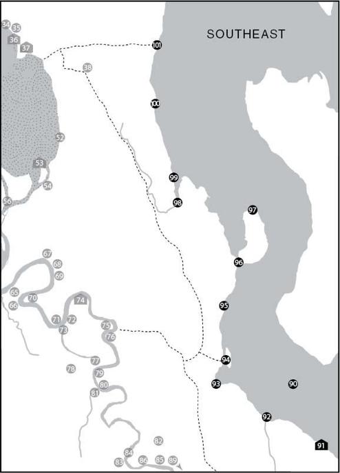
Map 3: Southeast
Leaving the Inside Place, we enter the homelands of the Lake People. The richness of the place-names along the Seattle side of Lake Washington is mirrored by that on its eastern shores and around the edges of Mercer Island.
90
Lake
XacH7oo (lit. ‘great amount of water’)
A generic term for large bodies of freshwater,
XacH7oo
gave its name to the Hachooabsh, or Lake Indians, a branch of the Duwamish proper who lived around the shores of Lake Washington. On some early maps of the area, this lake appears as “Lake Duwamish.”
91
Swimming Hole
sxWTéécHeeb (lit. ‘usual place to swim or wade’)
This town, located in what is now the Bryn Mawr neighborhood, was reputedly the birthplace of Chesheeahud. It is unclear how many houses were located here.
92
Ducklings
tSééptSeep
This onomatopoetic place-name has been replaced by the name “Taylor Creek,” which flows through Dead Horse Canyon on Seattle's southeastern boundary. It may in fact be the name of a particular unidentified species of small duck.
93
Loon Place
dxWwóóqWeeb
Loons would have found the Lake Washington shoreline an ideal habitat, and this marshy area would have been a particularly good spot. Prominent in Puget Sound mythology, Loon was a powerful spirit for warriors, hunters, and the owners of slaves. This place-name is a little puzzling in that the ending is
-eeb
instead of the expected
-ad
.
37
94
Small Island
TLúTLatSas
This is perhaps one of the best places to see the results of the lowering of Lake Washington. Prior to the completion of the ship canal, there had been a small island here, parallel to the shoreline and separated by
a marsh where, according to Harrington's informant, one “could pull canoes through except for [the] reeds.” Today, “Pritchard's Island” is now firmly attached to the mainland, although the former marsh is still a relatively wet area and is undergoing ecological restoration. A trail beginning near here went west over the hills to the Duwamish River.
95
Taboo Container
XaXa7óólcH
Some kind of malevolent power or spirit being resided at this place, now the site of Martha Washington Park. A Suquamish site near Manette with a name based on the same root was called
XáXa
‘to be taboo’ and signified the location of canoe burials in trees. (There is no evidence, however, of such a use for this location.) The term
XáXa
has a wide range of meanings, from ‘taboo’ and ‘forbidden’ to ‘holy’ and ‘sacred’ and also ‘ritually impure’.
96
High on the Neck
tSuqálapsub
Indigenous people were most likely responsible for burning the open, oak-dotted prairie slopes found near this isthmus by General Land Office surveyors in the 1850s.
97
Noses
squbáqst
Jutting out into Lake Washington, the Bailey Peninsula is home to Seward Park and some of Seattle's oldest trees. The name likely refers to the fact that the peninsula, which would have almost been an island before the lowering of the lake, has points at both its north and south ends.
98
Cooking Fish on a Stick
stSaKátSeed
Low-lying Genesee Park was once Wetmore Slough, which reached nearly to Columbia City's business district. It mouth was blocked up by logs and other debris that provided shelter for a large run of silver (coho) salmon (
Oncorhynchus kisutch
). The name of the place refers to one traditional method of cooking fish, still practiced today: the whole fish is opened lengthwise, splayed on sticks, and leaned over an open fire. A hop yard stood here in the nineteenth century, gathering in the fruit of Native labor from the fields of Puget Sound country.
99
Breast, Nipple, Breast Milk
sqúb7oo
The reason behind this name for a spring near Wetmore Slough has been forgotten; it may be a reference to milky, mineral-laden waters or simply to its nourishing qualities.
100
Changes-Its-Face
s7ayá7oos
Leschi Park, named after the Nisqually warrior who led the assault on Seattle in 1856, was once the home of a supernatural horned snake, similar to the one at the site of entry 40. One of the most powerful spirits available to Puget Sound shamans, Changes-Its-Face was enormous, had retractable horns that resembled an elk's antlers, could also live in the sky, and could see in all directions. Young people were warned to reject this spirit if at all possible, perhaps because of the heavy punishments meted out against healers who failed to cure their patients, but also because it could cause its holder to do malevolent things. One of Harrington's informants told him that the serpent that resided here departed during the early years of urban expansion.
38
101
Saw-Grass Point
xWqWééyaqWayaqs
This site was a place for gathering tules, or bulrushes (
Scirpus acutus
), which were woven into everyday household mats and screens. It was also the eastern end of a trail from Little Crossing-Over Place (37); as such, it served as the departure point for Leschi's attack on Seattle. Settlers used the trail as well, and the beach here became a popular “wilderness” destination during the city's early years and eventually part of the city's string of public spaces along the Lake Washington shoreline.
Map 4: Northeast
Besides being home to the Lake People, Lake Washington was also a transition to the Duwamish backcountry. The people living near the headwaters of the Sammamish watershed (the Sammamish River enters Lake Washington from the northeast) were often regarded as lower class by their neighbors, in part because they had direct access neither to the riches of Puget Sound nor to trade routes across the Cascades. Nothing captures this sense of “backwoodsness” more than the phrase used by coastal people to admonish an ill-bred child or an adult with bad taste by referring to a poor town in the remote hinterland: “deehLeehL cHuXW u tee7eehL tool7ál sQWaX” (This person is like someone from Issaquah).
39
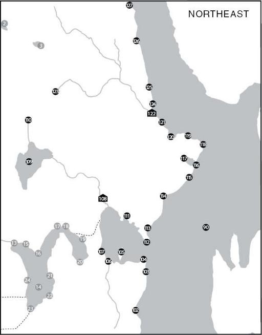
102
It Has Wolves
bastiqééyoo
Wolves once hunted throughout what is now Seattle but had been extirpated by the time white settlement reached the shores of Lake Washington.
103
Chopped
XeeTL
or
Gnawed
XeeTLéél
Two slightly different names were collected for the shoreline south of Madison Park. Waterman's name, Chopped, probably refers to dense forest that would have provided fine timber for canoes and house posts. Harrington's version, however, refers to things that have been gnawed, and his informant figured that there must have been beavers here. Prior to the excesses of the fur trade, beavers shaped the landscape nearly as much as their indigenous human neighbors by creating ponds and wetlands.
104
It Has Skate Fish
baskWéékWee7hL
Skates, as a saltwater species, did not live in Lake Washington; this name more likely refers to the low, flat shape of the land here at what is now Madison Park.
105
Little Island
stéétcHee
Now the southern half of Foster Island in the Washington Park Arboretum, this was a cultural site associated with the site of entry 108.
106
Baby Fathom
stáhLahL
The fathom, or more correctly the width of an adult's outstretched arms, was a common unit of measurement in Puget Sound indigenous life. This diminutive version of ‘fathom’ could also mean ‘niece’ or ‘nephew’.
107
Carry a Canoe
sxWátSadweehL
In 1854, pioneer leader Thomas Mercer visited Lake Union and envisioned a canal that would someday link the lake to Puget Sound and Lake Washington. In the 1860s, a settler named John Pike began digging a canal here by hand, and for a time there was a small log flume that connected the two lakes. Indigenous people had been crossing this isthmus for centuries, either carrying their canoes or shoving them along an intermittent creek that appeared when Lake Washington overflowed. General Land Office surveys from the 1850s show a well-worn “Indian trail” just north of here, approximately where the Burke-Gilman Trail is now, and oral tradition cites another trail to the south. With all this traffic, then, one wonders if the idea of the “union” of lakes and Sound was really Thomas Mercer's after all.
108
Little Canoe Channel
shLoowééhL (lit. ‘little canoe hole’)
Bearing the diminutive form of the name of entry 54, this was an important town with at least five longhouses and a large fishing weir on Ravenna Creek. The remains of that weir were exposed when Lake Washington was lowered in 1916; any evidence of the town itself has long been obscured by development around today's University Village shopping mall.
