The Medieval English Landscape, 1000-1540 (12 page)
Read The Medieval English Landscape, 1000-1540 Online
Authors: Graeme J. White

Although no medieval windmill now survives – except possibly the ruined bases of some tower mills, noted below – their appearance is known from illustrations and later surviving examples. The earliest type was the post mill, the whole body of which was rotated so as to catch the prevailing wind. These are known from illustrations both in the ‘Windmill Psalter’ of about 1270 (so named in the 1890s by its then owner William Morris) and in the
Luttrell Psalter
some 70 years later, from various depictions in stained glass, brasses, bosses, wall-paintings and carvings, and from post-medieval examples such as those at Bourn (Cambridgeshire), recorded in 1636 and possibly the oldest surviving in England.
122
The base of the post was supported by cross-pieces set into a flat-topped mound, and these low ‘windmill mounds’ – which served to elevate as well as to stabilize the mill – are occasionally identifiable today. A good example can be seen at Cold Newton (Leicestershire), inconveniently sited amid ridge and furrow but in the best place for the wind (
Figure 8
).
123
Tower mills, in which the body of the mill is fixed but the cap at the top, to which the sails are fixed, can be rotated according to the wind, are known to have been built from the late thirteenth century: accounts survive for the construction of a stone mill at Dover Castle (Kent) in 1294–95, which must have been of tower design, and there are illustrations of them in late-medieval wall paintings and stained glass, as in a window of Stoke-by-Clare Church (Suffolk). Truncated stone towers at Tidenham (Gloucestershire) and Burton Dassett (Warwickshire) may be the remains of former medieval tower mills.
124
Yet while it is tempting to regard windmills as an advance on watermills, because they were introduced later, they were never as popular: watermills were of greater potential size and (except in the specific case of tide mills) generally more reliable, since if they were well-positioned the source of power could usually be controlled. Accordingly, when let out for rent, water-mills normally commanded higher sums than windmills.
125
In this as in every other agricultural activity, there was good sense behind the decisions taken by our medieval ancestors, however surprising they sometimes seem to us today.
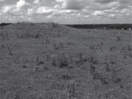
Figure 8: Windmill Mound, Cold Newton (Leicestershire)
. As a base for a post mill, the mound is characteristically flat-topped and positioned at an exposed high point. Medieval ridge and furrow runs either side of the mound but also stops short of it, suggesting that strips continued to be ploughed after the windmill had been established.
The landscape of rural settlement
I
f Leonardo da Vinci’s ornithopter, which he drew about 1485, had actually been built and – more to the point – had ever got off the ground, a flight over the late-medieval English countryside would have revealed a rich variety of settlement patterns: from places where, to quote William Harrison in 1577, ‘the houses … lie uniformly builded … together, with streets and lanes’ to those in which ‘they stand scattered abroad, each one dwelling in the midst of his own occupying’.
1
Scholars have coined the terms ‘nucleated’ and ‘dispersed’ to describe these different forms of settlement, though in reality there were, and still are, various gradations between the two extremes and in some contexts a lack of clarity over whether a given group of dwellings constitutes one settlement or many. Ultimately, a settlement was defined by its own sense of identity, carrying a place name intended to distinguish it from others, even if it was part of a greater unit (such as a parish or township) to which its inhabitants formally ‘belonged’ for administrative purposes. Even today, isolated farmsteads – settlements in their own right according to most definitions used by scholars today – are known not by numbers but by names. There is also no consensus on how to distinguish ‘hamlet’ from its perceived superior, ‘village’, some preferring size (such as a dozen households as the dividing line between the two), others function, a village being the ‘local centre of secular and ecclesiastical authority … the primary place of a particular manor or parish’ upon which hamlets were dependent.
2
The
Atlas of Rural Settlement
, discussed in the previous chapter, relies largely on nineteenth-century one-inch Ordnance Survey maps to divide the country into regions of different settlement types. This is based on the premise that the pattern of settlements can be classified according to the extent to which they were either nucleated or dispersed, the former
embracing those in which dwellings were clustered together in relatively large units (typically villages or large hamlets) with tracts of scarcely inhabited countryside in between, the latter covering scattered farmsteads and small hamlets: in areas of dispersion, the density of settlements might be greater, but the settlements themselves were very small. This raises a host of issues, because as the authors fully recognize there are realities on the ground which defy neat classification. But the
Atlas’
s broad division of England into three zones – a ‘Central Province’ largely comprising nucleated villages, a ‘South-Eastern Province’ of both ‘scattered nucleations’ and high density-dispersion, and a ‘Northern and Western Province’ in which dispersed settlement clearly predominates – carries conviction, however much debate there might be over the ‘sub-provinces’ and ‘local regions’ into which these zones are further broken down. Also very helpful are the estimates for England as a whole of between 10,000 and 12,000 villages and large hamlets, and between 3,000 and 4,000 communities (vills) consisting solely of dispersed settlements, at the zenith of medieval population early in the fourteenth century. All this provides a basis for further analysis, while leaving a lot of questions to be answered by ongoing research.
3
Most discussion of rural settlements treats them together with their associated field systems, the general argument being that nucleated villages were found in medieval England alongside the great open fields of ‘champion’ country, dispersed hamlets and farmsteads with the mixture of small open fields and closes encountered elsewhere. This fits with much of the evidence of medieval farming and settlement seen in the landscape today: travelling through the midlands, for example, one often passes through discrete villages each surrounded by extensive ridge and furrow or by straight hedges resulting from the parliamentary enclosure which did away with the open fields. It also fits with our understanding of what would have been most convenient to those working the land. If each householder’s strips were intermixed with those held by others, and distributed across the open fields, it made sense for everyone to live as neighbours in a centrally placed nucleated settlement, with the fields arranged around it. Conversely, if holdings were at least partly consolidated, into compact groups of closes with perhaps a few unenclosed strips, farmers would want to be near to where their land was concentrated; this would lead to a more dispersed settlement pattern. In broad terms, the link between settlements and field patterns is well-established and accordingly – as we saw in the previous chapter – the three great ‘Provinces ‘ of the
Atlas of Rural Settlement
provide a useful framework for the study not only of the distribution of villages and hamlets but also of the layout of their accompanying fields. But it was certainly possible to manage shared resources collectively from dispersed hamlets or farmsteads, and equally possible to farm individually held closes while living in a nucleated settlement. In any case, the coincidence of a particular settlement pattern with a specific type of field system does not prove that they arose together.
4
While we need to be alert to the fact that settlements and their associated fields were intimately connected, as different aspects of local land use, the origins of each deserve consideration in their own right.
There is now general agreement among scholars that in the first few centuries following the arrival of Anglo-Saxon settlers, rural England was essentially a land of dispersed hamlets and farmsteads. Given a free choice, the favoured mode of settlement in the countryside was to live in isolated dwellings or – at most – small hamlets, with handfuls of buildings clustered together in any one place at any one time. This isolation is familiar to most farmers in England today, as it is to those wealthy enough to buy or build palatial homes with scant regard to cost. Indeed, as far as rural areas are concerned, nucleated settlement has been described as a ‘short and aberrant episode in the long history of dispersed settlement which characterized all of this country’.
5
Many early Anglo-Saxon settlements also appear to have been relatively short-lived, lasting perhaps 250 years at most before their sites were abandoned in favour of others in the vicinity.
6
The story of how, when and why this changed to a settlement pattern which was more static and, over much of England, significantly more nucleated than hitherto is a complex one. As with the field systems discussed in the previous chapter, it involved a staged process in which different factors predominated at different times in different places. It seems clear that population increase was one important factor, leading to the growth of villages, generation by generation, out of one or more previous farmsteads and hamlets. Sometimes these small outlying settlements were abandoned in favour of one which expanded into a large ‘central place’, their names perhaps living on in the furlongs of open fields which spread over them. Sometimes they survived, grew and coalesced into ‘polyfocal villages’ with several nuclei connected by streets and lanes, a phenomenon first identified at Great Shelford (Cambridgeshire) through Christopher Taylor’s work with a WEA/Cambridge University Extra-Mural Board class there in the late 1960s.
7
However, this did not happen everywhere: outside the ‘Central Province’ of the
Atlas of Rural Settlement
(especially to its east where growth was highest), population increase led not to widespread nucleation but chiefly to an intensification of a dispersed settlement pattern, with new hamlets and farmsteads proliferating. So other factors were certainly involved.
The contrast between the midlands, with its village nucleations, and more-densely populated East Anglia, with its many small settlements, has been explored by Tom Williamson. He sees the technological advance represented by the introduction of a heavy wheeled plough with mouldboard – essential to the cultivation of the clay soils increasingly exploited from the eighth century onwards – as a significant development, because a large team of oxen was needed to pull such a plough; since most peasant farmers did not have enough animals of their own, they were obliged to pool their resources. In the midlands, he argues, there were advantages in settlement nucleation with peasants living as neighbours because a rapid, co-operative, response was needed to the limited opportunities available within a relatively short ploughing season and because there was abundant meadow to support fairly high concentrations of livestock. Conversely, where meadow was scattered and in short supply, as in much of the
Atlas’
s ‘South-Eastern Province’, there was a tendency for hamlets and farmsteads to hug the edges of ‘greens’, pockets of damp ground which offered a precious – but dispersed – resource from which some of them took their names. These common greens served both as pasture and as an alternative to meadow and were generally associated with smaller settlements and field systems, although there was considerable density to their dispersion across much of East Anglia and the south east.
8
Williamson was not primarily concerned with the ‘Northern and Western Province’ but his comments could also apply to some areas of dispersed settlement in this region as well, such as parts of the west midlands and Welsh marches where, again, several place-names ending in ‘Green’ are to be found. These ingenious theories have been challenged because they do not fit everywhere: within the midlands, the siting of settlements in the Whittlewood area on the Northamptonshire-Buckinghamshire border show no consistent correlation with the distribution of meadow, while in East Anglia there is an imperfect match between the greater density of nucleation, and greater development of open fields, in Norfolk and the greater abundance of meadow further south.
9
But if such considerations were irrelevant in some parts of the country, they may have been highly influential in others: they do not provide an all-embracing rationale for the diverse development of nucleated and dispersed settlements but neither does any other explanation. In tackling this subject, it is best to reject a monocausal approach.
Attention has been drawn to administrative changes from the late-ninth and tenth centuries onwards, as much of midland and northern England initially fell under Scandinavian occupation, only for Anglo-Saxon royal government embracing the whole of the country eventually to emerge stronger in response. This was a period when great estates broke up into smaller units, when the lords of those units sought to exploit them more efficiently (as the ‘manors’ of Domesday Book) partly because of the revenue demands of the
crown, and when the Church began to develop a parochial system based on local communities. These developments, all tending towards a reorganization of the way local resources were managed, have sometimes been seen as encouraging settlement nucleation.
10
There can be no doubt that the construction of manor houses and parish churches – the latter increasingly ‘built to last’ (in stone) after 1000 – introduced new focal points within a settlement around which housing might congregate.
11
But while there was stabilization of settlement in response to these circumstances – with sites coming to be occupied long-term rather than being abandoned after a couple of centuries – nucleation was far from being the inevitable consequence. In Cornwall, for example, ‘much of the emerging medieval landscape of settlement and agriculture appears to have been organised around … newly established churches’ but these ecclesiastical centres became ‘focal points in landscapes of highly dispersed settlement’ rather than village nucleations.
12
Herefordshire appears in Domesday Book with many of the ingredients which might be expected to lead to the development of nucleated villages with great open fields: a density of population similar to that in much of the midlands, relatively high amounts of arable land pressing on resources, and scarcely any ‘freemen’ among the peasantry who might have been inclined to resist the imposition of manorial control. It also has the highest incidence in the country of castle earthworks in close proximity to churches, which implies – if the present features can be taken as successors to pre-Conquest equivalents – that there had been some deliberation over how the settlements were laid out. Yet this is a county essentially of dispersed, not nucleated, settlement, much of it indeed ‘high and very high density dispersion’.
13
So as with the field systems considered in the previous chapter, we should abandon any attempt at determinism and envisage various cultural and perhaps psychological factors coming into play, as decisions on the arrangement of the community’s housing were taken in the light of the diverse demographic, environmental and administrative pressures outlined above. And just as with the fields, while we may envisage these decisions being taken sometimes by lords or their representatives, sometimes by peasant communities, sometimes by both together, they would have been based on the experience of neighbouring settlements and a perception of what would work best.
14