The Medieval English Landscape, 1000-1540 (14 page)
Read The Medieval English Landscape, 1000-1540 Online
Authors: Graeme J. White

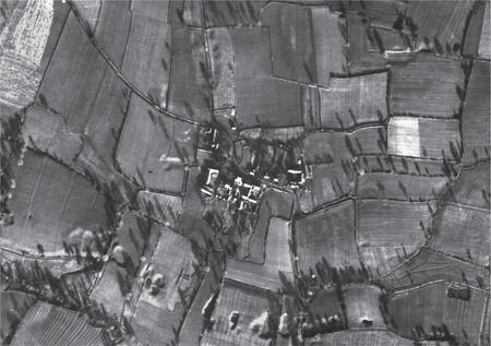
Figure 9: Burton near Tarvin (Cheshire)
. This hamlet has changed little since the RAF took the photograph in January 1947. It retains much of its medieval character as a planned settlement, with a row of tofts between the main street and a back lane to the north, and farmers living as neighbours to one another. (English Heritage NMR RAF Photography.)
Turning to dispersed settlement as a whole, we encounter a story of infinite variety, every bit as important for the study of rural settlement as that of the nucleated villages which have traditionally received more attention. Although growing population and more organized manorial administration were certainly factors which led to settlement nucleation, most places responded to these issues not by replacing their dispersed settlement pattern but by intensifying, adapting and refining it. Thus, at the isolated farmstead of Berry Court in north-east Cornwall, occupation has been traced back to the ninth century; in Essex, at hamlets such as Asheldham, pottery dating to
before the tenth century has been found at or very close to the subsequent settlement sites; in Staffordshire, scattered settlement around Shenstone, as at Hilton and Upper and Lower Stonnall, has been postulated to have been in existence by the eleventh century, even though the first documentary references to some of these places are much later.
30
All this suggests that, as part of a reorganization of the landscape paralleling that which was taking place in the ‘nucleated’ regions, dispersed farmsteads and hamlets, with their accompanying fields, were ‘settling down’ in fixed locations. The date when this happened varied, but that was the case with village nucleation as well. The process is nowhere better demonstrated than in Rivenhall (Essex), where the existing pattern of dispersed farmsteads and hamlets has been shown to have been largely in existence by the eleventh or twelfth centuries, preceded by a series of earlier Romano-British and early Saxon farms in different positions.
31
The fact that, in medieval Cornwall, dispersed settlement was associated with a landscape of open strips – possibly covering as much of 60% of the land surface at their maximum extent – while in Essex the countryside was dominated by hamlets, farmsteads and enclosed fields, with limited evidence of open arable over most of the county,
32
reinforces the dangers of attempting to link types of settlement and field system together.
Beyond the hamlets and farmsteads of the eleventh century onwards which can be shown to have had Saxon or earlier predecessors – in the immediate vicinity if not on exactly the same site – there were a host of dispersed settlements in medieval England which were the result of systematic clearance and colonization to feed a growing population. Much of this activity (like the settlement of Hound Tor on the lower slopes of Dartmoor) dates to the eighth-to-eleventh centuries, before it was captured in documentation. But once we have charters, surveys and other estate records there is no difficulty in illustrating this all over the country, as hitherto unrecorded settlements appear for the first time – sometimes incorporating the element ‘new’, sometimes words associated with woodland, enclosure, farmstead or shelter; the fact that they already bore names by the time they were first recorded suggests that they were almost invariably older than the dates to which they can be assigned.
33
It was this phenomenon which saw population in parts of the wooded Arden region of north-west Warwickshire, for example, increase fourfold between 1086 and 1279; detailed study of one parish within Arden, Tanworth, has shown a sustained attack on the woodland in this period, resulting in a landscape composed largely of single farmsteads each with their own separately held closes. Although each farmer held on average only about two hectares, this was supplemented by the resources of the surviving woodland and at least partially redeemed by the free status granted to those who cleared the land. In the similarly wooded environment of Hanbury, Worcestershire, where population doubled between about 1170 and 1299, several new place names had appeared by the middle of the thirteenth century in areas of woodland clearance, such as Blickley, Broughton and Becknor, all being treated as separate units of estate administration and evidently distinct hamlets; over 60% of the peasant tenants in Hanbury were freeholders by the close of the thirteenth century.
34
A similar process took place in the wetlands of eastern England, where there were some astronomical population increases over the same period, occasioned by the construction of banks to prevent flooding both from the sea and from inland watercourses, and by the drainage of what could thereby be reclaimed. An extra 250 square kilometres is believed to have been brought into cultivation within the Lincolnshire parts of Holland between 1170 and 1240, and in one parish here, Moulton, the parent village spawned two hamlets during the course of the thirteenth century (Moulton Chapel and the aptly named Moulton Seas End) as well as several farmsteads, all protected by banks. Similarly in the Cambridgeshire fens, 13 new free tenants were recorded in 1251 at
Apesholt
, a hamlet on a gravel ridge which had been set up in the outlying parts of the Bishop of Ely’s manor of Downham.
35
Colonization was sometimes undertaken as a project led by lords of the manor – who saw the potential for profit by allowing peasants and others
to win new land for cultivation in return for the grant of free status and future payment of rents – sometimes as a matter of individual or collective enterprise. Charters give the impression that lords were in control, but there must be a suspicion that in many cases they were merely regularizing a situation which had arisen already and ensuring that they received some rent in return. Sometime between 1200 and 1213, Amaury Earl of Gloucester gave to Richard de Crespi ‘ten acres of land of my assart at Nurstead (Kent) next to the house of William Huryng’; at around the same time in Devon, a peasant freeholder, Benedict son of Edric Siward, was granted by Guy de
Brittevilla
lord of Cornwood ‘all my land of Cholleswyht’ by closely defined boundaries, evidently the origins of the now-deserted hamlet of Cholwich over 200 metres above sea level on Dartmoor; on 25 May 1219, the Bishop of Lincoln granted to a more substantial figure, Walter fitz Robert (later described as a knight) and his heirs ‘all the assart made or to be made of our wood of Harthey’ (Huntingdonshire) with provision for the men and houses there to be treated as part of the bishop’s manor of Buckden, and later allowed Walter to build a chapel there.
36
In every case, an annual rent was specified, and in every case we have a glimpse of a new settlement, with its own name, coming into being, but there is at least a hint that the grants were retrospective. Even where lords clearly played a more active role in promoting colonization, a point would be reached where some responsibility was handed over to the incoming settlers. Thus, the ridgeway villages of Mayfield, Wadhurst and Ticehurst on the Sussex Weald all seem to have originated from thirteenth-century market grants obtained by their lords, who laid out the market areas in unoccupied parts of their estates but then left settlers to congregate around these nuclei without any further planning on their part: these have been described as ‘permissive settlements’, whose residents were encouraged to take advantage of the trading opportunities provided but without any lordly direction over their layouts.
37
When it came to taking decisions over how to occupy new land, organize settlement and arrange field systems, we must expect the peasantry, doubtless with some of the better-off freeholders playing a prominent role, to be fully capable of exercising initiative – with many of their lords happy to let them get on with it, content to benefit from the extra rent which would accrue.
Industrial activity in medieval England – if we exclude agriculture from the definition – was largely a rural affair, since it needed ready access to raw materials and to waterborne power supplies and these tended to be found
in the countryside. Accordingly, any discussion of rural settlement must take this into account. Obviously, there were many urban-based craftsmen and (especially before the thirteenth century) several towns active in the manufacture of cloth but – as we shall see in the next chapter – it was primarily as centres of commerce and administration that most towns flourished. The rural focus of industry meant that those engaged in mining or manufacture usually did so part-time, alongside their farming duties. Well over 1,000 coastal
salinae
(saltworks) are recorded in Domesday Book, mostly along the east and south coasts between the Humber and Plymouth Sound where there were a host of settlements engaged in the organized evaporation of seawater, but except in Devon and Dorset no specific
salinarii
(saltworkers) are mentioned: the implication must be that the rural peasantry – villeins, bordars or however they are recorded – were doing this work while also tilling the land. Crockerton (Wiltshire) bore a place name derived from its reputation as a pottery-making centre, but the population in 1234 was still listed according to its landholdings, which at less than two hectares for each peasant household would have made a second income imperative. Excavation of the deserted village of Lyveden (Northamptonshire) has revealed evidence of tile kilns and furnaces for the smelting of iron ore, but the structure and layout of the housing was typical of a peasant farming settlement – which, to a large extent, it remained. Blast furnaces, introduced at the end of the middle ages as a technological advance in the smelting of iron ore, had to await the completion of harvest before being ‘blown in’ after their annual summer service. Mining was also predominantly a seasonal occupation: fourteenth- and fifteenth-century lead miners have been reckoned to extract at most two tons of ore per annum, mainly in the period between mid-April and July when spring ploughing and lambing were over and haymaking and harvest had not yet begun. Stone quarries were worked not speculatively but in response to specific demands, so the labour was intermittent and ideally suited to men who had alternative work on the land. And, from the thirteenth century onwards, one of the major attractions of the countryside to the entrepreneurs who controlled the cloth industry was that some of the key processes, notably spinning and weaving, could be undertaken in the home as part-time family activities, free of the restrictive practices of urban gilds.
38
The consequence of all this is that industrial activity, though it sometimes left a considerable legacy in the landscape, is usually thought to have had limited impact on the pattern of rural settlement. It relied mainly on a workforce which was also engaged in farming and was already established in existing villages, hamlets and farmsteads. There are, for example, extensive tracts of ‘saltern mounds’ along the Lincolnshire coast, created by the distinctive method of saltmaking – found here and in the Solway Firth – of washing out the salt from saturated mud and sand, leaving dumps
of waste matter behind: but the associated settlement pattern, of hamlets and farmsteads colonized from parent villages inland, is essentially derived not from this ancillary activity but from the opportunities to exploit farmland newly reclaimed from the sea.
39
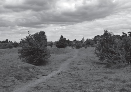
For their part, stone quarries have typically left a pockmarked landscape, nowhere better illustrated than by the ‘hills and holes’ of the great Jurassic limestone workings at Barnack (Cambridgeshire), (
Figure 10
), Taynton (Oxfordshire) and Ham Hill (Somerset), but given the sheer weight to be transported there was every incentive to locate them as close as possible to established routeways and population centres. Corfe (Dorset), a planned settlement where two streets fan out from the castle established here after the Norman Conquest, still has various trackways which led from these streets to the local Purbeck marble quarries, while Barnack, which lies immediately adjacent to its former quarries, has the regularly laid-out peasant house-plots typical of countless farming villages of the midlands.
40