The Rocks Don't Lie: A Geologist Investigates Noah's Flood (4 page)
Read The Rocks Don't Lie: A Geologist Investigates Noah's Flood Online
Authors: David R. Montgomery
Tags: #Non-Fiction, #Religious Studies, #Geology, #Science, #21st Century, #Religion, #v.5, #Amazon.com, #Retail

2

A Grand Canyon
F
INALLY
I
TOOK
the last step and reached the top. It had taken all day, but I had fulfilled an ambition to hike up through the world’s best-exposed story written in stone. Standing on the rim, I turned and looked down almost a mile to the bottom of the Grand Canyon, still marveling over the extraordinary tale preserved in the rock walls along the trail. Elated and exhausted, I left the rim and walked over to the National Park Service gift shop.
I picked up a small coffee-table book intriguingly titled
Grand Canyon: A Different View
. It told of how Noah’s Flood ripped up the surface of the world like a geological blender, laid down the great pile of rock exposed in the canyon walls, and then deftly excavated the canyon as the waters receded.
1
Digging deeper into the book, I read that the canyon itself was carved when the sediment that formed the rocks now exposed in its walls was still soft. I was puzzled that the authors did not try to explain how a mile-high stack of saturated sediment remained standing without slumping into the growing chasm—or how all the loose sand and clay later turned into solid rock. The book simply stated that, according to the Bible, Noah’s Flood formed the Grand Canyon and all the rocks through which it’s cut in under a year. There was no explanation for the multiple alternating layers of different rock types, the erosional gaps in the rock sequence that spoke of ages of lost time, or the remarkable order to the various fossils in the canyon walls. The story was nothing like the tale I read in the rocks I had spent the day hiking past.
The long plod out of the canyon still rang in my head as I returned the book to the shelf and stepped back outside. I savored the view and my day immersed in geologic time. Reading about earth history is one thing; to see and feel it for oneself is another.
I thought back to the beginning of my day, just after dawn. The towering rock walls rising above the bottom of the canyon baked in the early morning light as they’ve done for countless years. My knees still ached from the hike down two days ago; and the trail rising a vertical mile ahead promised another brutal hike under the Arizona sun. There was no alternative. I was committed to climbing out of one of the deepest holes in the world, passing through time from the dawn of life in the depths of the canyon to the modern desert at the top.
I approached the Colorado River, the clear turquoise water marking the start of the trail back up to the canyon rim. Watching the river flow beneath me as I crossed the footbridge, it dawned on me that the sediment-trapping Glen Canyon dam almost a hundred miles upriver robbed the river of the sand and erosive power that together cut a narrow slot into the hard rock exposed along the canyon floor.
Halfway across the river, at the far side of the bridge I saw a tunnel enter the rock wall rising from the river’s edge. I entered it and felt like I’d stepped back into deep time.
In the smooth rock walls I saw the signature of abrasive sand-charged floods surging down the canyon. The surface of the hard, crystalline Vishnu Schist was a polished face made of intergrown quartz, feldspar, and mica stretched and folded at high temperature and pressure, deformed into great swirling patterns. Deep within the earth, below a now-vanished mountain range, the schist in front of me had crystallized long before dinosaurs, about a third of the way back through geologic time. But it didn’t start out as hard rock. Ghost beds of sand lie preserved as light-colored, quartz-and-feldspar-rich layers sandwiched between dark layers of ancient mud now baked into aluminum-rich mica and garnet. This layering is a telltale sign that the schist formed when the sand and mud of an ancient seabed were buried deep enough to recrystallize and deform like melting ice cream.
To get hard rock to flow requires both extreme heat and high pressure. Recrystallizing and deforming the particular combination of minerals in the Vishnu Schist takes temperatures of 900–1300°F and more than three thousand times atmospheric pressure. Geologists know from temperatures measured at the bottom of deep drill holes that it gets 104–122°F (40 to 50°C) hotter with every mile below ground. We can surmise from this that the schist was approximately ten miles below the surface when it formed, twice as far down as Mt. Everest is tall. The bottom of the canyon exposes the roots of an ancient mountain range, visible today only because of the erosion of the overlying rock that had to have lain above the canyon walls to turn all that sand and mud into solid rock in the first place.
How long ago did the schist form below those ancient mountains? More than a billion years ago, although no one can tell just by looking at the rocks. Using the right tools, the age of a rock can be read like a geologic clock because radioactive isotopes decay at a fixed rate. Radiometric dating is based on the fact that younger rocks have more of the initial parent isotopes of their radioactive elements and older rocks have proportionately more of the daughter isotopes produced by radioactive decay. If you know the half-life of an isotope—how long it takes for half the remaining amount to decay—then the ratio of the parent-to-daughter isotope now in a rock tells you how long ago the rock crystallized.
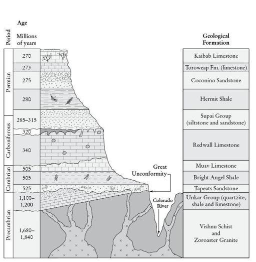
Stratigraphic column showing the rock formations exposed in the walls of the Grand Canyon
(
based on a sketch by Véronique Robigou
).
Uranium-lead dating is the radiometric method commonly used to date the oldest rocks. The 4.47-billion-year half-life for the decay of uranium 238 (
238
U) to lead 206 (
206
Pb) is about the planet’s age. Zircon, an uncommon mineral found in rocks like granite, is ideal for this dating method, as it strongly excludes lead from its structure upon crystallization. Because of this, all the
206
Pb in zircon had to have come from the decay of
238
U, since the mineral cooled. Geologists use a mass spectrometer to measure the amount of
206
Pb and
238
U in a grain of zircon and determine the age of the rock from the ratio of the two isotopes.
Continuing along the trail, thin bands of pink granite rise like fossilized stripes and cut through the swirling Vishnu Schist. These narrow lines of granite, called dikes, have uranium-lead ages of up to almost 1.7 billion years and neatly truncate the banding in the schist, adding a geometric flourish to the fluid forms crystallized in the inner canyon’s rock wall. I could tell the schist is even older because the granite dikes cooled in cracks within it. The schist was already there when the granite cooled.
I felt like an ant crawling along the narrow trail as I snaked my way out of the inner gorge. Once I gained enough elevation, I could look down on the river and across to the other side. There, I could see a sequence of tilted rock layers on top of the Vishnu Schist and tucked in below the flat-lying Tapeats Sandstone that defined the upper lip of the inner gorge. Pitched up at a jaunty ten- or twelve-degree slant, this stack of limestone, shale, and quartzite (a hard rock made when sandstone is heated deep within the earth) records the changing depth of water in an ancient sea, deep-water limestone on the bottom giving way first to shale made from offshore mud and then to sandstone from a fossilized shoreline.
Whether eroded by rivers, wind, or waves, the truncated upper surface of the schist, together with the hardened marine sediment sitting right on top of it, is evidence that rocks once buried miles underground were brought to the surface, exposed to the elements, and then buried again deep below the bed of an ancient sea. After all this, the whole package got tilted up and planed off by erosion for a second time before being capped by the sediment composing the still flat-lying rocks rising far above. I could see it all laid out in the cliff, right across the river—two rounds of uplift and erosion buried beneath a three-thousand-foot-high wall of rock. An ancient story only unveiled because the Colorado River carved the Grand Canyon.
The striking outcrops of the inner gorge illustrate several simple rules geologists have used for centuries to read the story of rocks the world over. The first is that layers of sedimentary rock that accumulate in depositional environments, like sandstone and shale, represent time and are deposited horizontally. This makes sense, since these rocks form by settling through water under the influence of gravity, the way mud settles to the bottom of a glass of water. The second is that rocks at the bottom of a pile are older than those above them. This, too, seems obvious. And where one formation cuts off another, it is the younger that cuts across the older. Using these simple rules—determining what’s above what, and what cuts through or across what else—is how geologists decipher stories of time and change written in stone. Of course, there is more to knowing how to read Earth’s story, such as how two other types of rocks—igneous and metamorphic—are made, but simple interpretive rules apply to all rock types.
2
Everywhere on Earth is either eroding and losing material or receiving deposits of material eroded off of somewhere else—one geologic realm sheds sediment, the other accumulates it. But the places where each is happening change over time. The most obvious change apparent in the walls of the Grand Canyon is that the marine rocks exposed in it have switched from one domain (deposition) to the other (erosion). Eroded upland environments are not preserved in the rock record because there’s nothing left to see—they’ve vanished. The geologic signature of mountains is recorded by its absence, a gap in the record of time, while the story of our planet and life on it is archived in the sediments of depositional lowlands and marine environments—the places where sediment piles up over geologic time.
Deciphering earth history involves establishing the basic relationships between different rock formations and the nature of the boundaries, or contacts, between them. Two layers of sedimentary rock deposited one atop the other without any discontinuity are considered conformable—they accumulated with minimal interruption. An eroded surface leaves a discontinuity between two rock units, a gap representing missing time that geologists call an unconformity. An unconformity represents how far down erosion wore into an ancient landscape before additional sediment was deposited on top. A whole series of unconformities exposed in the canyon walls tell of multiple rounds of deposition, deformation, and erosion before the whole package of rocks rose from the sea to the level at which we find them eroding today.
After far too many switchbacks, I made my way out of the inner canyon and across a cliff of flat-lying rock. In passing, I traced my finger along the surface of the unconformity where the Tapeats Sandstone rests on the irregular surface of the Vishnu Schist. The now solidified grains of sand settled onto a rocky seabed in the Cambrian Period, about 100 million years before plants began colonizing land.
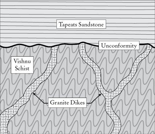
The great unconformity at the base of the Grand Canyon where the Tapeats Sandstone truncates the Vishnu Schist
(
based on a sketch by Véronique Robigou
).