Frozen in Time (11 page)

Hudson's Bay Company searcher John Rae was the ï¬rst to hear of the ghastly possibility of cannibalism among Franklin expedition crewmen. In the spring of 1854, Rae was given details of the expedition's ï¬nal days by Inuit who also had in their possession a variety of artefacts. Rae recorded their descriptions of a shocking sight:
From the mutilated state of many of the corpses and the contents of the kettles, it is evident that our wretched countrymen had been driven to the last resourceâcannibalismâas a means of prolonging existence.
The response to this testimony was immediate and ï¬erce. Many Britons simply refused to believe cannibalism was possible. Charles Dickens, who followed the Franklin search closely, spoke for them when, in 1854, he argued that Franklin expedition crewmen represented the “ï¬ower of the trained English Navy⦠it is the highest degree improbable that such men would, or could, in any extremity of hunger, alleviate the pains of starvation by this horrible means.”
Dickens then attacked the source of the stories, the Inuit, as “covetous, treacherous and cruel⦠” Writing in
Household Words,
he said:
In weighing the probabilities and improbabilities of the âlast resource,' the foremost question isânot the nature of the extremity; but the nature of the men. We submit that the memory of the lost Arctic voyagers is placed, by reason and experience, high above the taint of this so-easily allowed connection; and that the noble conduct and example of such men, and of their own great leader himself, under similar endurances, belies it, and outweighs by the weight of the whole universe the chatter of a gross handful of uncivilised people, with a domesticity of blood and blubber.
United States Chief Justice Charles Patrick Daly, president of the American Geographical Society, went a step further, charging that Franklin was “murdered by the Indians, who had already imbued their hands in the blood of white travellers.” Rae fought back, arguing,
I consider it no reproach, when suffering the agony to which extreme hunger subjects some men, for them to do what the Esquimaux tell us was done. Men so placed are no more responsible for their actions than a madman who commits a great crime. Thank God, when starving for days, and compelled to eat bits of skin, the bones of ptarmigan up to the beak and down to the toe-nails, I felt no painful craving; but I have seen men who suffered so much that I believe they would have eaten any kind of food, however repulsive.
Fifteen years later, Rae received corroboration from Charles Francis Hall, who had also heard the tales of cannibalism and reported them in much greater detail. Even today, the stories are abhorrent. The Inuit reported ï¬nding boots “that came up high as the knees and that in some was cooked human ï¬eshâthat is human ï¬esh that had been boiled.” Wrote Hall: “Some bones had been sawed with a saw; some skulls had holes in them.” Other bodies found nearby had been carefully stripped of all ï¬esh, “as if some one or other had cut it off to eat.”
Even three decades after the disaster, gruesome accounts continued to be collected from the Inuit of the region. Lieutenant Frederick Schwatka's 1879 search recorded “almost unmistakable evidences of their being compelled to resort to cannibalism.” An Inuk named Ogzeuckjeuwock reported seeing “bones from legs and arms that appeared to have been sawed off⦠The appearance of the bones led the Inuits to the opinion that the white men had been eating each other.” Schwatka's account was compelling and, according to one British newspaper, had ï¬nally “cleared the reputation of a harmless people from an undeserved reproach.”
It is difficult for those sated in their daily demands for food and drink to believe that any civilized person would intentionally and knowingly eat human brains, consume strings of arteries or split open bones so that the marrow could be picked out and eaten. That fact is no different today than it was during Queen Victoria's reign. Yet under certain dire, life-threatening circumstances, many people would come to the realization that seems to have faced the last tattered remnants of Franklin's expedition, that cannibalism is all that stands in the way of sure death.
Modern disasters, such as the 1972 crash of a chartered plane in the Andes Mountains of South America, provide insights into the rationale for consuming other humans. One of those to survive the Andes crash explained later in an interview:
Real hunger is when you have to eat human ï¬esh. But when you see yourself growing thinner and thinner and weaker every day and see the bones standing out and feel your eyesight dimmingâyou make the decision to live by whatever means possible.
Prehistoric occurrences of cannibalism associated with starvation provide striking similarities to the Booth Point skeleton ï¬ndings. An archaeological investigation of an Anasazi settlement in the American Southwest revealed 11 skeletons that had been dismembered and processed for eating: “The overall picture of skeletal destruction is that of dismemberment, crushing of long bone shafts, facial mutilation, scattering and loss of elements of the trunk (ribs, vertebrae, and pelves), and the loss of hands and feet.”
So cannibalism follows a pattern: once the decision is made, the initial sections removed from the body are the meatier areas like the buttocks, thighs, lower legs and arms. Recognizably human parts, such as hands and feet, are not eaten at ï¬rst. As time passes and hunger continues to tear at the survivors, the options of where the ï¬esh comes from are reduced, and bone marrow, organs, arteries and skin are consumed. Removal of muscle tissue is usually done with a knife or other sharp object, and this can leave butchering marks on the bone. Removal of bone marrow requires the bone to be smashed open. The brain is either pulled through the base of the skull or eaten after the face is cut off. The need by members of Franklin's dying crew for a portable food supply was the reason for the only exceptions to this pattern.
A small group of the last survivors of the doomed expedition trudged eastward along the south coast of King William Island in July or perhaps August 1848. The exhausted men probably continued to hold out hope that they would reach the mouth of the Back River, from where they would attempt to travel nearly 1,000 miles (1,500 km) upstream to the safety of a Hudson's Bay Company fort located on the eastern edge of Great Slave Lake. Slowing signiï¬cantly as a result of increased exhaustion aggravated by scurvy, their food supply at an end, the sailors must have desperately looked for alternative food sources. But there were too few birds' eggs to feed the group and hunting on the sparse northern island would have been unrewarding.
When their food ï¬nally ran out and they were too ravaged by hunger and disease to continue, the men sat down and prepared to die. But with the ï¬rst death came new hope. The survivors must have found themselves contemplating a stark fact: starvation need not be a factor any longer.
Cannibalizing the trunk of the body would have given them enough strength to push on. The head, arms and legs, easily portable, were carried along as a food supply. Finally they came to a part of the island that turned sharply to the northeastâaway from their goal. Camping on a small spit of land near Booth Point, the same spit of land later visited by the University of Alberta researchers, they ate their last meal. Disease and physical deterioration continued to drain them of energy as they turned southward across ice-covered Simpson Strait, avoiding the many long, thin slivers of black seawater slicing through the ice and the turquoise and azure pools of meltwater, making their way towards Starvation Cove. For them, the adventure and the suffering would soon be over.
In surveying the King William Island coastline the following year, Beattie, this time with ï¬eld assistants Walt Kowal, a graduate student in anthropology at the University of Alberta, Arne Carlson, an archaeology and geography graduate from Simon Fraser University in British Columbia and Inuk student Arsien Tungilik, planned to retrace the searches of M'Clintock in 1859 and Schwatka in 1878â79.
Although both nineteenth-century searchers had discovered the skeletal remains of crewmen at a number of sites, the surveyors would concentrate on Schwatka's published accounts, since the explorer had found and described more of these ï¬nds. Schwatka had also gathered up the scattered bones and buried them in common graves at the various sites, placing stone markers on them. Beattie hoped these graves could be located, and, with great anticipation, plotted their supposed position using Schwatka's journals and maps. From the descriptions of bones buried at some of the sites, the number of crewmen represented could be four or more.
After a three-and-a-half-hour ï¬ight south from Resolute on 28 June 1982, the Twin Otter supplied by the Polar Continental Shelf Project swept over Seal Bay on the west coast of King William Island. Spotting a dry gravel ridge near the beach, the pilot circled back, ï¬ying close to the ground and as slow as aerodynamics would allow. The co-pilot opened a door and, with the help of Arne Carlson, booted a crate ï¬lled with supplies out of the plane. All watched as the box bounced a few times and rolled to a stop on the ridge, its pink-coloured cloth wrapping visible from miles away. The aircraft then headed south along the coast to Erebus Bay, where a similar procedure took place. (The run-off from melting snow on King William Island made landings too risky that season, and the staff at the Polar Shelf base in Resolute came up with the idea of the air drops.)
The scientiï¬c team then headed on to Gjoa Haven, where ï¬eld assistant Arsien Tungilik was picked up. The Twin Otter soon ï¬ew back towards the northwest coast. After a time, the pilot suddenly banked the plane to the leftâhe had spotted a potentially good landing site in a land otherwise covered with summer run-off. Gesturing to Beattie, he pointed out of his window to the beach ridge and nodded his head. Looking at his map, then out the window, Beattie nodded back that the site, about 3 miles (5 km) north of Victory Point, would make a good starting point for the survey. After making one more low-level pass, the pilot put the plane down with feet to spare and, with one engine left running, the scientiï¬c crew jumped out of the plane's side door and began unloading their supplies. Within ï¬ve minutes everything was piled outside, and the pilot and his co-pilot pulled themselves back up into the plane. After restarting the second engine and throttling up, the plane edged forward. Seconds later it was airborne and heading north, then immediately it banked and ï¬ew past the group on the ground, the pilots waving as they set course for distant Gjoa Haven to refuel before their return to Resolute.
Although the team's food caches had been dropped along their planned route, each person's backpack was weighed down with food and supplies. Extra clothing for temperatures expected to hover around the freezing point, and other personal items, were usually stuffed to the bottom. Next came the food, consisting mainly of packaged freeze-dried goods and chocolate bars. Other important items such as matches, tent- and boot-repair kits, ï¬rst-aid kits and ammunition were packed near the top. Sleeping bags were tied to the bottom of the packs, with a tent and sleeping pad strapped one to each side. The riï¬e and shotgun were attached to the top and could be reached easily while the pack was on. Other items that increased the weight of each load were the cooking utensils, stoves and fuel. A radio was carried, with which they would make twice-daily contact with the base camp at Resolute. Later, when leaving a cache site, their packs would be stuffed to overï¬owing with supplies and more things would be hanging from straps on the outside.
Each team member was burdened with one of these heavy packs (Beattie and Tungilik carried more than 60 pounds/30 kg; Carlson carried even more), but it was Kowal, a powerful man with seemingly endless energy, who served as the self-assigned workhorse for the survey party. During the ï¬rst phase of the ï¬eldwork, Beattie and Carlson had to lift Kowal's pack up to help him get it on. In it, in addition to his own belongings, he carried food, the radio, a riï¬e, ammunition, a sleeping bag and pad, a tent, an inï¬atable raft, a set of oars, two camp stoves, his camera and, strapped to the back of the pack, a full 5-gallon (23-litre) container of stove fuelâfor a total weight of more than 130 pounds (60 kg). Beattie was amused and amazed at the sight of Kowal as they moved along on their survey: a huge mountain of supplies appeared to be lumbering ahead on its own, powered by two legs that would disappear as Kowal squatted to investigate something on the ground. The mountain would then slowly rise and continue along on its course.
Loaded down as they were, each researcher had to move slowly to conserve energy. The survey needed alert minds and inquisitive eyes; fatigue would steal those necessary qualities away. They took frequent rests supplemented by liquids (tea, coffee, hot chocolate) between each camp. Even with these breaks, they were able to survey between 6 and 12 miles (10 and 20 km) each day, and when searching an area out of one of their established camps, they took only the necessary supplies for one day, greatly increasing their range and speed.
Their ï¬rst day on the island, even before they had a chance to set up camp, a curious Arctic fox was noticed studying them from a nearby beach ridge. Beattie thought of the brief visit by the small animal, still covered in its heavy white winter fur, as a form of welcome to the strange and exotic island they were about to explore. Although Beattie had visited King William Island's south coast the previous year, he was about to survey areas where people had not been for many years.
When the fox had scurried off into the distance, the four surveyors busied themselves setting up the tents of their ï¬rst camp and preparing a meal of freeze-dried food. After settling in, despite being tired from the long plane journey, they then brieï¬y explored the surrounding area. Walking inland soon brought them to a large lake, and they could see in every direction that the land was ï¬at and virtually covered in a sheet of water.
The following morning, as they moved northward along the coast, the temperature gradually warmed to 41ËF (5ËC), the sun emerged and the wind shifted so that it was blowing off the island. The team stopped brieï¬y to remove parkas, then continued in shirt sleeves for the remainder of the day. The warmth of the season resulted in great quantities of meltwater ï¬owing towards the coast from inland lakes, which made surveying conditions very difficult and almost impossible along parts of the route. Each mile of coastline covered usually required two or more miles of walking. Although their plan was to survey completely up the coast to Cape Felix, on the northwestern tip of the island, it would be physically impossible on foot. So when they reached a swiftly ï¬owing stream at Cape Maria Louisa, 12 miles (20 km) south of Cape Felix, they decided to turn south. After searching unsuccessfully for a Franklin campsite that had been discovered in the area by M'Clintock and Hobson in 1859, they then camped for the night, returning to near Victory Point the next day.
Breaking camp on the morning of 30 June, the four men carried their supplies southward to the bank of another swollen stream. The depth of the water and speed of the current were too great to consider wading across, and they had to skirt round the outï¬ow by walking out onto the ice of Victoria Strait. They wrapped their supplies in a large orange tarpaulin, tying the corners together. Then, dragging this large bundle and burdened with their overstuffed backpacks, they picked their way over the broken piles of ice at the waterline and out onto the smoother ice further offshore.
For the next two hours they walked, waded and jumped over fractures and cracks in the ice and areas of open water created by the stream, until they were able to angle back to the safety of the shore on the far side of the stream. After kicking off their boots and taking a well-earned rest, the survey then continued south along the shoreline to the place visited by James Clark Ross in 1830, subsequently named Victory Point.
Standing on the low rise of the point and looking south, Beattie was astonished by the accuracy of the scene, as depicted in an engraving made from a sketch drawn by Ross during his explorationsâpart of his uncle Captain John Ross's failed 1829â33 expedition. James Clark Ross described his visit:
On Victory point we erected a cairn of stones six feet high, and we enclosed in it a canister containing a brief account of the proceedings of the expedition since its departure from England⦠though I must say that we did not entertain the most remote hope that our little history would ever meet an European's eye.
Despite the accuracy of the engraving, nothing could be found of the cairn erected by Ross. Only a small cairn dating from the mid-1970s remained.
Victory Point is a low gravel projection into Victoria Strait, rising less than 33 feet (10 metres) above the high-water mark. From this spot it is possible to see Cape Jane Franklin several miles to the south, glazed with a permanent snow cover on its western rise, and to the west, the thin, horizontal dark line of Franklin Point. Ross named these features in 1830, in the case of Franklin Point writing in his journal that “if that be a name which has now been conferred on more places than one, these honours⦠are beyond all thought less than the merits of that officer deserve.” (In one of those instances of tragic irony, Sir John Franklin would die within sight of Franklin Point and Cape Jane Franklin, seventeen years later.)
Two miles (3 km) south of Victory Point, Beattie and his small party came across another, much smaller, projection of land, marking the site where the crews of the
Erebus
and
Terror
congregated on 25 April 1848, three days after deserting the ships 15 miles (24 km) to the NNW. It is this place that, along with Beechey Island, forms the focal point for the discovery of the fate of the expedition, for a note of immeasurable importance was left here, providing some of the few concrete details relating to the state and action of the crews from the wintering at Beechey Island in 1845â46 to the desertion of the ships on 22 April 1848.
Setting up camp, Beattie prepared to spend two days thoroughly researching and mapping the site as well as surveying the surrounding area. The two tents were placed so that their doorways faced each other; the team could then sit and prepare meals and talk in their own makeshift courtyard. During that ï¬rst evening, the sky and clouds to the south darkened to a deep purple and bolts of lightning ï¬ashed out from the clouds, reaching down towards the ground. Although orange sunlight still shone on their camp, the four watched with anxiety as the dark storm moved westward to the south of them. The site, known as Crozier's Landing, was so ï¬at that their metal tent poles were prominent featuresâperhaps even lightning rods. They were relieved when the storm at last faded from view.
By 1982, few relics of the Franklin expedition remained at Crozier's Landing. Where piles of the crews' discarded belongings once lay strewn about, only scattered boot and clothing parts, wood fragments, canvas pieces, earthenware container fragments and other artefacts could now be gleaned from among the rocks and gravel. One rusted but complete iron belt buckle was found during the survey, as was a stove lid, near the spot where M'Clintock had located a stove and pile of coal from the expedition. A smashed but complete amber-coloured medicine bottle was also found, as was part of the body of a clear glass bottle, complete with navy broadarrow marking.
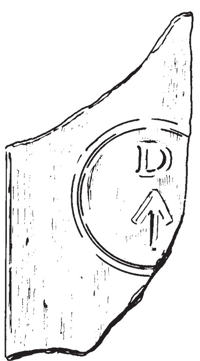
Glass fragment showing the navy broadarrow.
What struck Beattie was the paucity of the remains marking this major archaeological site. How could a place with such a history of tragedy and despairâshared by 105 doomed soulsâappear so impartial to the events that transpired here during late April 1848? The artefacts that were mapped and collected in 1982 were pathetic, insigniï¬cant reminders of the failed expedition. Disturbances at the site were such that a search for the grave of Lieutenant John Irving, discovered by Schwatka, failed to turn up anything, though a series of at least thirteen stone circles indicated the actual location of the tenting site established by Franklin's men. Other tent circles attested to the visits by searchers, primarily M'Clintock and Hobson in 1859 and Schwatka in 1879, and by Inuit. Evidence of more recent visits were also clearly visible: a hole excavated by L.T. Burwash in 1930, small piles of corroded metal fragments (possibly the remains of tin canisters), a note left by a group during an aerial visit made in August 1954 and other signs of visits made within the last decade. A modern cairn is situated at the highest point of the site, representing the approximate location of the cairn in which the note was discovered by Hobson in 1859.