Frozen in Time (15 page)

Down in the hold, surrounded by the creaking of the wooden hull and the stale odours of men far too long enclosed, John Torrington lies dying. He must have known it; you can see it on his face. He turns towards Jane his tea-coloured look of puzzled reproach.
Who held his hand, who read to him, who brought him water? Who, if anyone, loved him? And what did they tell him about whatever it was that was killing him? Consumption, brain fever, Original Sin. All those Victorian reasons, which meant nothing and were the wrong ones. But they must have been comforting. If you are dying, you want to know why.
âMargaret Atwood, “The Age of Lead”
Mr Franklin smiled upon them all; he had a marble-white smile, like a tombstone angel, like a shot beluga whale on the beach; he slowly stretched the white rubber-marble skin of his face; as the lead-sugars and lead-garnishes of Mr Goldner worked themselves more thoroughly into his system, he came by degrees to bear more resemblance to another kind of whale, a grey one, gravel on its heavy skinâ¦
âWilliam T. Vollmann,
The Riï¬es
It is clear that all went exceedingly well for Sir John Franklin during the ï¬rst months of his expedition. The
Erebus
and the
Terror
dodged through the ice of Baffin Bay in 1845 and quickly passed through Lancaster Sound, the eastern entrance to the Northwest Passage. Finding their westward progress impeded by a wall of ice in Barrow Strait, Franklin turned his ships north into the unexplored Wellington Channel for some 150 miles (240 km), penetrating to 77ËN latitude. A second barrier of ice probably forced the expedition to retreat along the west and south coasts of Cornwallis Island (thus making clear that the land mass was an island) before ï¬nding a winter harbour at Beechey Island. Here, they settled into their ï¬rst winter campsite, doubtless ï¬lled with a sense of purpose. They had not yet found a passage, but the coming summer held every hope of success.
But ï¬rst, Franklin and his 128 menâmost of whom were without previous polar experienceâhad to contend with the approaching twenty-four-hour darkness and bitter cold of the Arctic winter. They would be completely isolated from all other human beings and beyond hope of rescue for many months should something go wrong; then came the deaths of John Torrington, John Hartnell and William Braine.
Speculation as to the cause of death of those three men dominated Owen Beattie's thoughts, when, on 10 August 1984, he and a scientiï¬c team consisting of pathologist Dr. Roger Amy and research assistants Walt Kowal, Joelee Nungaq and Geraldine Ruszala lifted off in their Twin Otter from Resolute and turned eastward for the ï¬ight across the choppy waters of Wellington Channel to Beechey Island. As the aircraft approached the distant cliffs of their destination and nearby Devon Island, there was little to provide a sense of scale. But as the plane descended, rounding the northern spit of Beechey Island, then closed in on the sloping area of Franklin's winter camp, Beattie was astonished at how insigniï¬cant the islet looked alongside massive Devon Island.
Beattie had never visited the historic site before and, peering out of the window as the plane passed by the graves about 100 feet (30 metres) above the ground, he was deeply moved by the site's vulnerability. Along the whole eastern slope of the island, the headboards of John Torrington, John Hartnell and William Braine were the tallest features visible, framed by towering, vertical cliffs to the west and the shore of Erebus Bay to the east.
Adjacent to the graves was a landing area, scored by long parallel wheel marks in the gravel where other planes had landed, some perhaps earlier that summer, others many years before. The pilot, ï¬ying by the graves, checked out the makeshift landing strip and the wind direction. He then powered the Twin Otter up and out over Erebus Bay, turned sharply towards the cliffs and, pulling out of the turn, lined up with the landing area. Skimming only a foot or two over mounds of gravel, the plane, ï¬aps now fully extended, was committed to a short ï¬eld-landing. With the graves directly off the left wing, the main wheels touched down into the gravel. Immediately the pilot brought the nose wheel down, applied the brakes and reversed thrust on the propellers. The plane came abruptly to a full stop.
After half an hour spent unloading a huge pile of supplies, the team stood back and watched the plane lift off and ï¬y out over Union Bay, then into the distance, the droning of the engine gradually replaced by quiet. For the ï¬rst few minutes, the crew strolled around the site. They were struck by the absolute isolation. Apart from the Antarctic and perhaps a handful of other places, there is nowhere in the world where a person can face solitude as in the Canadian Arctic. Even the presence of a few workmates does not compensate for the emptiness and loneliness of the far north.
The ï¬rst task was to construct a temporary home, much as Franklin's men had done here many years earlier. Everyone helped to pitch two large communal tents, and, as soon as these were ready, ï¬ve sleeping tents were set up. Two large long-house tents, measuring 12 by 18 feet (3.7 by 5.5 metres), would provide much-needed living space for a crew whose sleeping tents were large enough only for a sleeping bag and backpack. Each long-house tent had a strong tubular aluminium skeleton, covered by a canvas outer skin; another canvas cover was tied on the inside. These two layers would provide excellent protection from the wind, rain and snow. A heavy canvas ï¬oor covered the sharp gravel. The door consisted of a double ï¬ap that could be tied tightly shut. When the tents were in position, the radio aerial and a weather station were assembled and raised.
Beattie spent time that ï¬rst day on Beechey Island studying the tiny Franklin graveyard where he hoped some answers lay buried. The three graves lay side by side, about 26 feet (8 metres) above sea level. He planned to begin by exhuming Petty Officer John Torrington, who was probably the ï¬rst on the expedition to die. Interred alongside Torrington were Able-bodied Seaman John Hartnell and Private William Braine.
Torrington's headboard was simple, but both Hartnell and Braine had inscriptions taken from the Bible carved on theirs. Hartnell's included the following passage: “Thus saith the Lord of Hosts, consider your ways.” Haggai, i,7.', while Braine's read, “Choose ye this day whom ye will serve” Joshua, xxiv, 15.' These unusual inscriptions have prompted some searchers and historians to suggest that foul play or mishap marred that ï¬rst winter. One of the jobs of a forensic anthropologist is to interpret whether foul play could have caused or contributed to the death of an individual. Before the work started on Torrington's grave, Beattie wondered what he might ï¬nd.
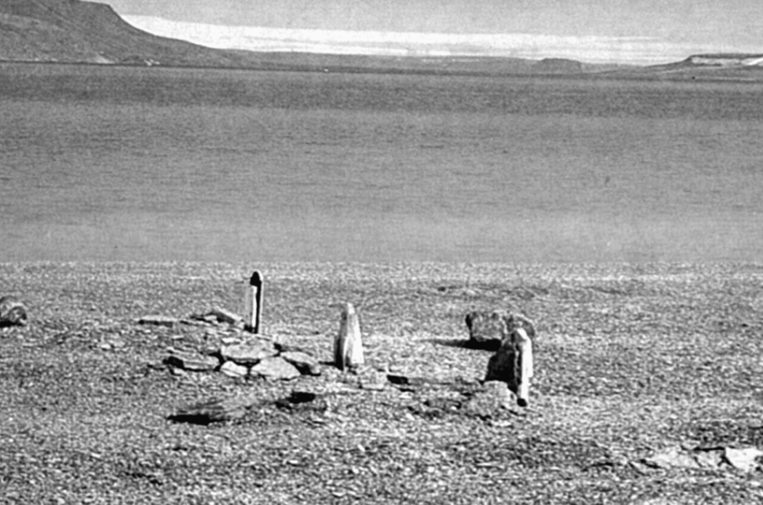
The Beechey Island gravesite: The graves, from right to left, are of Thomas Morgan of the Investigator
(d. 1853); and from the Franklin expedition, Private William Braine RM (d. 3 April 1846), Able Seaman John Hartnell (d. 4 January 1846), Petty Officer John Torrington (d. 1 January 1846); and a ï¬fth, unidentiï¬ed grave.
Two days after the ï¬rst members of Beattie's scientiï¬c team arrived, a second Twin Otter ï¬ew in carrying project archaeologist Eric Damkjar and research assistant Arne Carlson. Damkjar brought news of a family emergency to Nungaq, and the young assistant left on the same aircraft.
Torrington's grave was carefully staked out, mapped, sketched and photographed so it could be restored to its original state upon completion of the exhumation. Each stone covering the grave, from the tiny 2â4-inch-high (5â10-cm-high) stone fence made of limestone shingle that surrounded it to the stones that covered the burial mound itself, were numbered with water-soluble ink to assist the scientists in reconstruction.
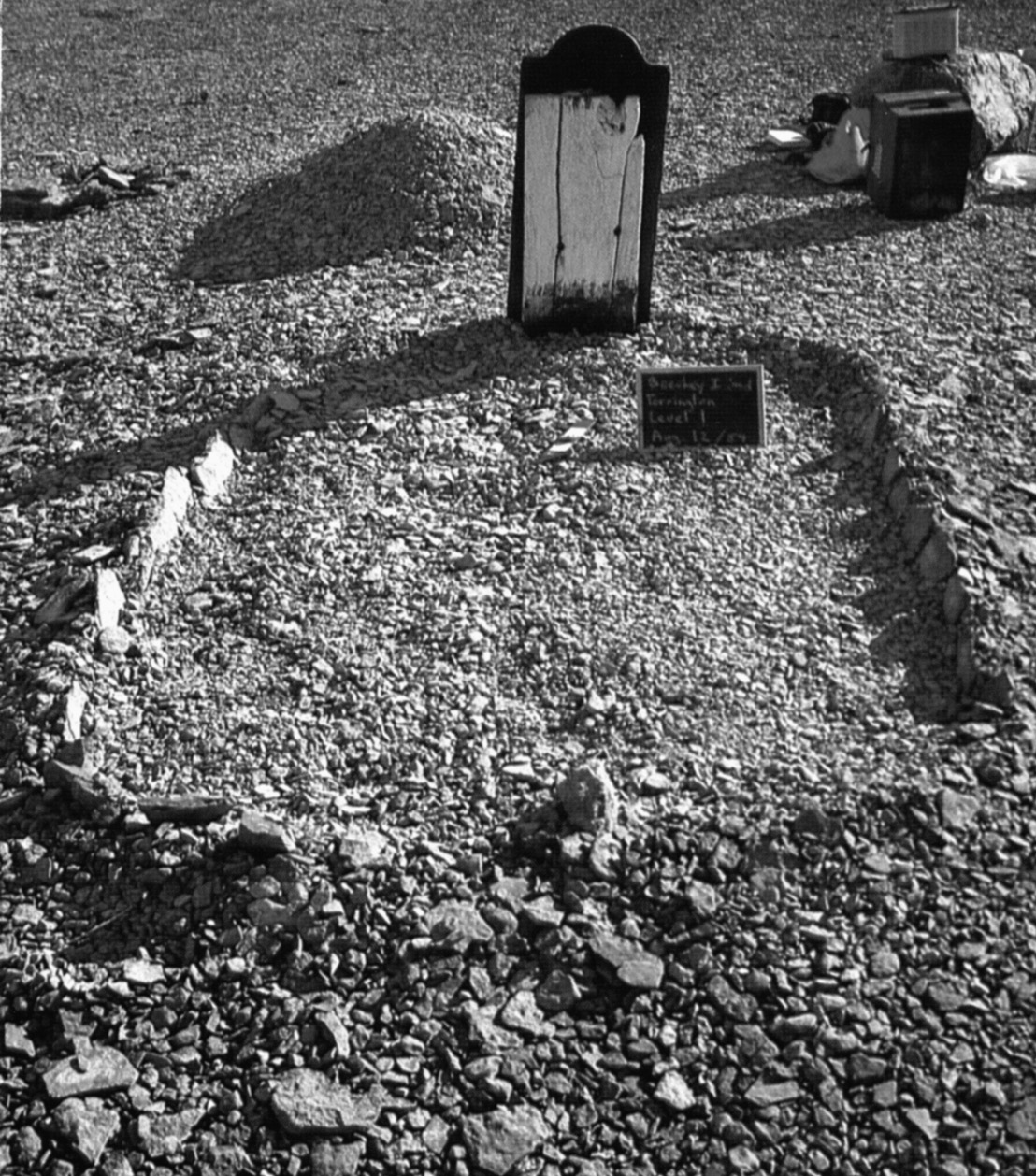
The grave of 20-year-old John Torrington after the removal of the gravel mound. Notice the row of small limestone shingles that form a fence-like feature around the grave.
They worked surrounded by the permanence of the stark and seemingly ancient land. But for the lonesome graves, a few remaining Franklin relics and their own small cluster of tents, there was nothing human in the place. The hard, angular coastline of Devon Island juts out in the distance east of Beechey Island, with cliffs rising some 660 or more feet (200-plus metres) out of Lancaster Sound and Barrow Strait. When the land is covered with snow, the stratigraphy of the cliffs produces marked horizontal stripes of white and grey that appear like a chart of the ages. Beechey Island itself is actually a very small appendage to the southwest corner of Devon Island, to which it is connected by a narrow ï¬lament of gravel barely 13 feet (4 metres) across in parts and within the reach of windblown ice. It was ï¬rst seen by Europeans on a cold August day in 1819. Captain William Edward Parry brieï¬y described landing on Devon Island:
The ï¬rst party landed at the foot of a bluff headland, which forms the eastern point of this bay, and which I named after my friend mr richard riley, of the Admiralty.
(It was on that point of land, Cape Riley, that searchers would ï¬nd the ï¬rst traces of the Franklin expedition thirty-one years later.) Then Parry looked to the west, across a bay that now bears the name of Franklin's ship,
Erebus,
at what would eventually become one of the most important and recognized sites in Arctic exploration:
⦠on the side of the bay, opposite to Cape Riley, was an island; to which I⦠gave the name of beechey island, out of respect to SIR WILLIAM BEECHEY.
Parry never set foot on the tiny island he named.
The northeast corner of Beechey Island slopes ï¬rst gently upwards from the shore of Erebus Bay through a series of level beach ridges ideal for the construction of small buildings, or a graveyard. Upslope from the area used by Franklin and his crews, the land rises more steeply, culminating in high cliffs that overlook the campsite and the bay where the two ships would have been locked in the ice. The top of the island is remarkably ï¬at, and in the southwest corner of the plateau, overlooking Barrow Strait, Franklin had the large rock cairn built. From this vantage point, 590 feet (180 metres) above sea level, it is possible to see Somerset Island 40 miles (70 km) to the south; Cornwallis Island is easily visible 30 miles (50 km) west across the entrance to Wellington Channel.
A small stream cuts down to the south of Franklin's camp area, past the grey gravel covering the three graves, before emptying into Erebus Bay. Only in July and August does the stream come to life, providing a source of water for visitors to the site. In July, when the sun has warmed the rocky ground, hardy ï¬owers bloom, ï¬lling the landscape with tiny random pockets of bright colour. But in August, as the team worked, the blooms had already fallen away.
On 12 August 1984, having erected a tent shell over the grave to protect it from the elements, the University of Alberta researchers began to dig through the ground of Torrington's grave. It took them less than an hour to remove the top layer of gravel using shovels and trowels, but when the excavation reached 4 inches (10 cm) into the ground, the men encountered cement-like permafrost. After a short, unsuccessful experiment in melting the permafrost with hot air, they resorted to pick and shovel to attack the frozen ground.
Soon after the uppermost levels of the permafrost had been chipped, broken and shovelled away, a strange smell was detected in the otherwise crisp, clean air. At ï¬rst it wafted upwards intermittently, mingling with the smell from the smashing, sparking contact of pick with gravel, but as the excavation deepened the smell gained in strength and persistence and soon dominated the work. Although not totally the smell of decay, it served to remind Beattie of what he might encounter. But not until much later, when the coffin was fully exposed, would the true origin of the smell be determined.
Two long days were spent struggling through almost 5 feet (1.5 metres) of permafrost before the researchers got their ï¬rst glimpse of the coffin. At the deepest part of the excavation, ï¬eld assistant Walt Kowal, carefully clearing off a thin layer of snow at the foot-end of the grave, exposed a small area of clear ice. Beneath the ice casing he could see dark blue material. Until this discovery, there was speculation as to whether anyone was actually buried in the grave. Torrington's body might have plunged through the ice into the freezing waters and been lost; other expeditions of the period had constructed dummy graves as a form of memorial. Or maybe the body would be simply missing, removed sometime during the past 138 yearsâa possibility that ï¬rst occured to the exasperated team when they had dug about 1.5 feet (.5 metre) below the top of the permafrost. As the researchers struggled deeper and deeper into the ground and still found no sign of a coffin, the thought that the grave really might be empty began to seriously trouble them. So when Kowal saw the blue material, he shouted, “That's it! We've got it!” and stood back with a sense of accomplishment and relief.
Beattie and the others quickly gathered and knelt in a close circle around the discovery. With such a small area exposed it was impossible to determine what the fabric represented. Beattie thought it might be a section of the Union Jack. Others speculated it might be part of a uniform, a shroud or the coffin itself. But for a time the material was left under the thin cover of ice. Although the researchers had obviously discovered something in the grave and were anxious to continue, Beattie was still awaiting the exhumation and reburial permits from the government of the Northwest Ter-ritories, notiï¬cation of permission from the Royal Canadian Mounted Police and clearance from the chief medical officer. What had been done up to that point was considered archaeological work and was covered by a separate permit. Having established the exact location of the body, Beattie was now forced to call an end to the excavation until the required permissions arrived.