Read In the Footsteps of Lewis and Clark Online
Authors: Wallace G. Lewis
In the Footsteps of Lewis and Clark (24 page)

The same year Alexander lamented the fact that superhighways were helping to consign historical remembrance to the ash heap, Roy E. Appleman wrote that “only in the high Bitterroot Range of Idaho and in the badlands of the White Rocks section of the Missouri in Montana can one today see this western wilderness for any considerable extent essentially as Lewis and Clark saw it.” Appleman, a National Park Service historian, laments that sites had been obscured or wiped out by industrial activity and especially by dam construction on the Missouri, Snake, and Columbia rivers. Around 2,350 miles of Missouri River bottomland, on which the expedition camped,
Appleman complains, had disappeared beneath the waters of impoundments, accounting for more than 500 miles of shoreline in South Dakota alone.
8
Hydroelectric power dams had shorn the Great Falls of the Missouri and its companion waterfalls of much, and in some cases all, of their spectacular beauty. Camp Fortunate, where Lewis and Clark had conferred with the Shoshone and bargained for horses to cross the mountains and where Sacagawea had immeasurably improved their chances for success by recognizing her brother Cameahwait, was covered over by reservoir waters behind Clark Canyon Dam in 1963. On the Clearwater River at Kamiah, Idaho, a sawmill had obliterated the site of Long Camp, where the expedition had prepared to recross the Bitterroots in the spring of 1806.
9
In the mid-1960s Ted Yates set out to produce a documentary film for NBC that would tie the landscapes through which Lewis and Clark traveled to descriptions from the expedition's journals. He found the task nearly “impossible.” Yates bemoaned the “relentless civilizing” that had made the country Lewis and Clark saw vanish as a result of cultivation, dam building, and other forms of development. As for the Columbia River, Yates found it “impossible to photograph most of the way. Its technology, its wires and signs and roads and motels and picnic sites and highways and barges and locks and docks defied our best efforts to film the wild and awesome river that the explorers wrote about.” Even without “road signs and high-tension wires,” the Lolo Trail was difficult to photograph, he said, because of the pervasive evidence of clear-cut logging. Yates concluded that he and his crew had, with great difficulty, “reconstructed America to look the way many of us dream [that] it looks,” yet they had also managed to add to the “delusion” and “sustain” the myth of American scenic beauty.
10
The scenes from the journals had largely vanished. “We followed the Missouri River west nearly two thousand miles,” Yates later wrote, “before we came upon remnants of the land they saw.” The river itself had also changed. “It is corseted, dammed, and polluted, a kind of superbly engineered sewer. . . . Our film remained unexposed until we reached North Dakota,” where sixty miles of free-flowing river could be found. Of the Great Falls of the Missouri, in western Montana, Yates noted that the film crew had to arrange “with the Montana Power Company to put some water over one of the falls for us.” Numerous dams built by the Army Corps of Engineers had altered aspects of the route along the Snake and Columbia rivers as well. Two of the dams, The Dalles and Bonneville, erased a fifty-five mile stretch of cascades, falls, and rapids through which the Corps of Discovery had passed with great difficulty on both the outward and return trips. In general, it can be said that the mission carried out by the Corps of Discovery ushered in developments that resulted in such alterations to the landscape and the expedition's path of discovery. In any case, the conditions confronting Ted Yates were the same as those that confronted the National Lewis and Clark Commission in 1964, when it began to study and designate a national trail honoring the expedition. Inundated portions of the route represented a particular challenge for interpretation. For this reason, perhaps, public recreation appears to have been as important as history, at least in the case of the lower Missouri, where the emphasis was on developing water recreation sitesâsomething both the Army Corps of Engineers and the Bureau of Reclamation had been pursuing for some time.
11
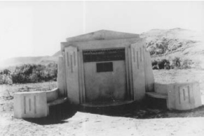
Fig 5.1
Concrete monument marking the site of Camp Fortunate at Armstead, Montana, had to be moved to higher ground when Clark Canyon Reservoir filled in 1963. Photographer unidentified. Courtesy, Beaverhead County Museum, Dillon, Montana.

Of course, not all changes have been caused by human settlement and industry. Even in Lewis and Clark's time, the Missouri River was in a constant state of flux. Flooding, siltation, and bank erosion created new channels, islands, and bends while abandoning old ones. Floodplain cottonwood groves and thickets of willows and other vegetation grew in some stretches of the river and dried up or were inundated in others, all of which has altered or eliminated many sites associated with the expedition. The most significant locations affected by river activity include the approximate site of Camp Wood, where the Corps of Discovery wintered in 1803â1804 before setting out on the expedition. The bed of the Missouri River has moved several miles to the south, that of the Mississippi has moved east, and the mouth of the Wood River in Illinois has moved northeast. In short, the geographical site today is believed to be on the Missouri side of the Mississippi and well north of the mouth of the Missouri River. The Council Bluffs site, where Lewis and Clark first conferred with Missouri Valley tribes, has moved west three miles from the river into Nebraska. The actual location of the winter camp of 1804â1805, Fort Mandan in North Dakota, has wandered into the body of the stream.
12
Within fifty years of his burial, erosion of the riverbank near Sioux City, Iowa, had threatened the original grave of Sergeant Charles Floyd, the only member of the expedition who perished. In 1857 Floyd's remains were moved 600 feet from the river and re-interred.
13
Interest in tracing the route Lewis and Clark took by way of the Missouri River, as opposed to land, goes back at least seventy-five years. Few enthusiasts attempted to follow the trail upstream by water, although that had been a commonâif hazardousâoption by river steamer upstream to Fort Benton, Montana, before completion of the Northern Pacific. The Missouri River was changeable and dangerous, as the expedition journals note abundantly, and the currents were notoriously strong and treacherous at times.
14
In 1928 travel writer Lewis R. Freeman rode a light steel skiff
down
the Yellowstone and Missouri rivers and described his adventure along a portion of the Corps of Discovery's water route in
National Geographic Magazine
. Beginning at Livingston, Montana, Freeman braved Whitewater “riffles,” snags, and shallow bars as he bobbed down the Yellowstone,
carefully noting likely locations and topographical features mentioned in Clark's journal. Freeman floated all the way to the confluence of the Missouri and Mississippi rivers, romantically conscious of the fact that the shorelines were redolent of history. “From the Grand [River] on down,” he wrote, “every bend and every bluff was peopled with memories of the men who had blazed the way. Every hedge and point beyond reach of the claws of the river I knew had been looked upon and probably camped upon by earlier explorers.”
15
Upriver attempts to trace the Missouri portion of the route by boat or canoe have encountered much greater difficulty, although east to west has traditionally been the direction to follow the trail, by land or by water. Once the middle Missouri had turned into a series of long lakes, boating likely became a more practical alternative, although in many places the current was actually stronger than it had been during the nineteenth century. In 1968 an eight-person “Lewis and Clark Scientific Field Expedition” from Charles County Community College in La Plata, Maryland, set out in sixteen-foot canoes to follow the route and survey ecological conditions and recreational possibilities. The currents were so much stronger than those the explorers had encountered in 1804, said one member of the group, that “the original expedition couldn't have run upstream with [the Charles County expedition's] equipment.” That same summer, seventy-two-year-old Ray Burkett, in a solo attempt to follow the trail upriver, found that he had to exchange the five-horsepower motor with which he had equipped his small boat in St. Louis for a ten-horsepower outboard to make any headway. Even then, he had to upgrade to an eighteen-horsepower outboard before reaching North Dakota.
16
In 1971 a contingent of twenty-nine Green Beret combat veterans from Fort Bragg, North Carolina, made its way up the Missouri, traveling by canoe from St. Louis to Three Forks, Montana, then overland to the Columbia River and down to the site of Fort Clatsop near Astoria, Oregon. Boy Scouts participated in numerous canoe expeditions along various segments of the river, particularly during the sesquicentennial commemorations in 1955. In 1972 the Great Lakes of South Dakota Association joined with Boy Scout groups in the area to establish a Lewis and Clark Historical Canoe Trail from Pickstown, South Dakota, to Sioux City, Iowa.
17
Despite such attempts to follow the Lewis and Clark route by watercraft, the National Lewis and Clark Commission and its successor organizations faced formidable difficulties in establishing and interpreting a commemorative trail along the middle Missouri River, where the most severe alterations to the original route had taken place. Even before the commission came into being, dams and reservoirs created as part of the massive Pick-Sloan project had obliterated much of the route and displaced descendants of the tribes with which the Corps of Discovery had spent its first winter en route to the Pacific Coast.
This is not to imply that midâtwentieth-century dam builders had ravaged a virgin wilderness. Human attempts to alter the Missouri began long before 1941, when the U.S. Congress authorized the Bureau of Reclamation and the Corps of Engineers to construct the main-stem dams of the Pick-Sloan project. The project, however, had done little to counter the biggest problem in navigating the riverâfluctuating water levels. The dugouts and keelboats of the fur trade, as well as the later paddlewheelers that seasonally steamed up the river as far as Fort Benton, faced virtually the same obstacles that had plagued members of the Corps of Discovery in 1804 and 1805. At times, the water on the upper river was too shallow to safely operate large craft. As Stanley Vestal has pointed out, “The trouble with going up the Missouri River in a boat is that you have to take the boat along.”
18
In addition to presenting navigability headaches, the Missouri periodically flooded farms and cities that had grown up in its flood-plains. By the 1880s, U.S. Army engineers had begun to systematically remove trees and snags and to attempt to curtail the river's tendency to change course, usually to little avail. Locally financed flood-control levees and efforts by the Corps of Engineers to improve navigation by digging channels were also ineffective in the early twentieth century. Particularly devastating floods in 1943, however, stimulated the U.S. Congress to pass a flood-control act authorizing the Army Corps of Engineers to develop an overall plan for protection along the river's course. Meanwhile, the Bureau of Reclamation was drawing up its own plan for harnessing the Missouri and its tributaries. The Dust Bowl droughts of the 1930s, when populations in the Missouri Basin declined sharply, had added irrigation to the reasons for clearing and
stabilizing the river. The many purposes of the massive Missouri River Basin Project, established in 1944, reflected the competing aims of these two agencies. The Corps of Engineers was concerned primarily with flood control, river navigation, and production of hydroelectric power. Colonel Lewis A. Pick, of the Omaha office, proposed a system of dams above Sioux City, Iowa, and levees or channelization on the lower river. The Bureau of Reclamation, for its part, favored development of irrigation, with power production a secondary consideration. The bureau was especially distressed that comprehensive reclamation development in the basin might be adversely affected by the corps' activities in improving river navigability. The bureau's plan, drawn up by William Glenn Sloan, called for a large number of smaller dams and reservoirs and numerous power plants.
19
