Read In the Footsteps of Lewis and Clark Online
Authors: Wallace G. Lewis
In the Footsteps of Lewis and Clark (27 page)

Objections quickly followed from different quarters. The
Wall Street Journal
article that had lambasted the commission for promoting road building had also criticized it for blending “historical scholarship and promotional showboating” and “succumbing to crassly commercial tourist promotion.”
61
Life Magazine
called on
all
federal commissions to dissolve themselves, and even Representative John Kyl of Iowa, who had authored the bill creating the National Lewis and Clark Commission, opposed granting indefinite life to temporary commissions on principle.
62
Kyl's suggestion that the commission be replaced by a private organization was echoed by North Dakota commissioner John Greenslit, who also served as coordinator of the North Dakota State Outdoor Recreation Agency. He acknowledged that “a new organization is needed with state initiative,” since Congress appeared unlikely to renew the commission.
63
Indeed, the U.S. Congress rejected a bill to extend the National Lewis and Clark Commission for five more years, and it was disbanded in October
1969. Within days, representatives of the eleven states that had participated in the commission's work began to seek ways to continue the project themselves, in cooperation with various citizen volunteer groups and federal agencies.
64
The initiative now rested with local, state, and regional organizations. In every state that had been represented on the National Lewis and Clark Commission, groupsâboth public and privateâbegan to implement the commission's recommendations. Even more important, perhaps, the volunteers and state organizations worked to maintain public interest in the Lewis and Clark trail. County committees had been established in Missouri and Iowa. In many of the other eleven states concerned, governors appointed state committees to pick up the slack, but an umbrella organization that would continue to coordinate efforts and keep the idea of a national historic trail in the public eye was clearly needed.
65
One of the final recommendations the National Lewis and Clark Commission had made was that “one or more groups should be organized to further the broad program” it had originated. In 1970 a nonprofit organization, the Lewis and Clark Trail Heritage Foundation, Inc., was formed for that purpose.
66
Also, a mimeographed publication,
The Lewis and Clark Journal
, edited by G. Edward “Gus” Budde of the Lewis and Clark Trail Committee of Missouri, appeared quarterly during the early 1970s. The publication reported on meetings, legislative efforts, issues related to historical sites, trail development news, and projects supported by the Heritage Foundation. Budde, described in a newspaper article as “one of the last of the old-time publicity men,” had “personally retraced” the trail from Wood River to Fort Clatsop eight times.
67
In the winter of 1974â1975 the first issue of
We Proceeded On
, the official publication of the Lewis and Clark Trail Heritage Foundation, noted that the Bureau of Outdoor Recreation was ready to submit legislation to the U.S. Congress to establish historic as well as scenic trails.
68
In the summer of 1976 the Valley County (Montana) Lewis and Clark Trail Society began to publish
A Squawl of Wind
, a periodical dedicated to articles and news about Lewis and Clark sites in northeastern Montana. Much of the writing was done by Bob Saindon of Glasgow, who later served as president of the Lewis and Clark Trail Heritage Foundation.
69
These and similar activities were dependent on the enthusiasm of Lewis and Clark buffs and others who had long sought to institutionalize a national trail. It seems doubtful that a top-down campaign by the federal government could have maintained interest at such a high pitch through the late 1960s and early 1970s or acted as quickly to preserve threatened landmarks. For example, a group of concerned citizens, led by one-time president of the Montana Historical Society E. E. MacGilvra, sought to save Beaverhead Rock from partial demolition. The rock, located near Twin Bridges northeast of Dillon, was famous as a landmark Sacagawea recognized as the Corps of Discovery moved past the forks of the Jefferson River on August 8, 1805, thereby assuring the explorers that they were close to the ultimate source of the Missouri and to Sacagawea's people. In 1970 most of Beaverhead Rock was on private property and destined to be quarried for “rip-rap,” rocks used to line riverbanks. A Butte newspaper claimed that Meriwether Lewis had carved his name on the rock face but that it had been obliterated sometime before 1970 by blasting at the site. Public “resentment” and a letter to the property owner from Senator Mike Mansfield of Montana led to a halt of the blasting, and eventually the site was nominated for protection as a National Historic Place.
70
While much of the post-commission activity took place at the local and regional levels, the task of developing a plan for legislation to create a national trail fell to the Bureau of Outdoor Recreation within the Department of the Interior. During the early 1970s the bureau began to investigate a way to fit the Lewis and Clark route within the recently enacted National Trails System. The study, which would define “the associated scenic, historic, natural, cultural, and recreational qualities which establish the national significance of the route,” focused primarily on the “main river courses . . . within a 10-mile corridor,” adhering “as accurately as practicable to the main historic route.” One of the criteria for National Scenic Trails was “national significance.” The “scenic, historical, natural, or cultural qualities of the areas through which” the trails passed were to be superior to, presumably, run-of-the-mill trails: “National scenic trails should, with optimum development, be capable of promoting interest and drawing power that could extend to any section of the conterminous
United States.” Trails “of major historic significance should adhere as accurately as possible to their main historic route or routes.” National Scenic Trails were to be several hundred miles long and “primarily land based.” Further, they were required to be continuousâthat is, not intermittentâand to have access from other trails “at reasonable intervals” as well as allowing for “trips of shorter duration.” By 1975 the Pacific Crest Trail and the Appalachian Trail had been so designated, and numerous candidates other than the Lewis and Clark route were being studiedâincluding the Mormon, Santa Fe, Continental Divide, Natchez Trace, Oregon, and Alaska Gold Rush trails. But it was becoming apparent that large segments of the Lewis and Clark trail did not qualify as “land based national scenic trail.” Little of the trail had potential for bicycling or hiking, for example, except in specific locales such as parks. However, a “historic” trail alternative soon came into being that would permit a different conception of what constituted a national trail.
71
The adoption of a National Historic Trail and Travelway category provided for extended routes that were hundreds of miles long. Portions would be used for foot or non-motorized travel, travel along or on waterways, or motorized travel along marked public highways and roads. The trails' national historic significance would be sufficiently documented, and they would be marked by interpretive sites to “provide the user with the intangible elements of historic feeling and association.” In a preliminary report (1975), the Bureau of Outdoor Recreation recommended that while the entire 3,700-mile Lewis and Clark route should be so designated, development was to be restricted to 135 miles of land and 2,010 miles of water within twenty-one “selected federally administered and complementing State and locally administered components.” Considered a “travelway,” authorized segments of the Lewis and Clark route could fit into the designation under less restrictive criteria.
As might be expected, the new routes authorized under this category by the U.S. Congress were to be “substantially of a historic nature” and to “possess exceptional values or qualities which illustrate or interpret the heritage of our Nation.” They would be either “recreation/interpretive” trails on which “only travel by foot, horseback, bicycle, or other non-motorized means would be permitted,” or they
would comprise “selected public highways and roads approximating the historic alignment of a historic route and [be] marked to facilitate retracement of the route by motorized vehicle or bicycle.” They could also be a combination of the two. Segments of historic trails and travelways had to “retain much of their historic character” and be largely free of “man-made developments of a disruptive or distracting nature” to be considered. However, segments that ran through agricultural or otherwise developed areas could qualify if they contributed, through “proper interpretation,” to the trail user's “knowledge of the country through which the trail passes.” Furthermore, although designated highways were expected to closely follow “the route's historic location,” exceptions could be made “to maximize recreation opportunities.” The implementation of both historic trails and historic travelways was required to preserve wildlife habitat, “fragile areas of vegetation,” and archaeological sites, as well as historical sites. Most of the Lewis and Clark trail did not qualify “as
a land based national scenic trail” since the expedition had traveled primarily by water, and it was doubtful that the public would make much use of any hiking trail that ran along the original route, even if only on the overland segment.
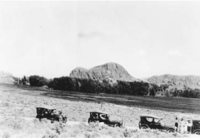
Fig 5.2
An expedition to Beaverhead Rock near Twin Bridges, Montana, probably in the 1920s. The rock, an important landmark on the Lewis and Clark trail, was saved from blasting in 1970. Photographer unidentified. Courtesy, Montana Historical Society Research Center, Helena.

By the time the Bureau of Outdoor Recreation's final report was completed in April 1977, most of the states along the Lewis and Clark route had established related trail systems and completed the interpretive projects they had pledged to the National Lewis and Clark Commission in the 1960s. Much of the work had been done to locate and mark historical sites related to the expedition. Planned access roads and recreation areas had also been developed by the states, the Bureau of Reclamation, the U.S. Forest Service, and the Army Corps of Engineers. The Bureau of Outdoor Recreation noted that although about 50,000 travelers intersected the trail routes every day by automobile, mostly on interstate highways, only a “very small percentage of the total use of the Lewis and Clark Trail [was] expected to come from people attempting to trace the entire route . . . an arduous task which takes several weeks and would not appeal to most trail users.”
73
The Lewis and Clark National Historic Trail officially came into existence on November 10, 1978.
74
The result on the middle Missouri River turned out to be a necessary compromise in many ways: a travelway rather than a scenic trail in the usual sense, a recreation ribbon through the Dakotas in a segment of the trail where proposed recreation sites outnumber located historical sites by a ratio of nearly three to one. Yet from both the ecological and historical points of view, significant efforts have been made to preserve portions of the river in a way that resembles its state at the time the Corps of Discovery passed along it. The Big Muddy National Wildlife Refuge in Missouri, the Hamburg Bend Wildlife Management Area in Nebraska, and the DeSoto National Wildlife Refuge in Iowa, for example, have resulted from cooperation among the U.S. Fish and Wildlife Service, the Army Corps of Engineers, and other federal and state agencies. Tasks include restoring habitat and countering the negative effects of channelization by digging “chutes,” or side channels, through some of the bends to form backwaters and wetlands, thereby allowing the river to “manage itself,” to some extent. More than thirty similar projects
are planned for the lower Missouri River. Many important historical locations have been spared inundation and remain available in free-flowing segments of the river above and below Bismarck, North Dakota, and downstream from Oahe and other dams. The 149-mile White Rocks section between Fort Benton and the head of Fort Peck Reservoir in Montana has been preserved as part of the National Wild Scenic River System, as have fifty-nine miles in South Dakota and Nebraska, downstream from Gavins Point Dam. Despite 100-foot-deep slack water from the Holter hydroelectric dam north of Helena, Montana, the Gates of the Mountains portion of the route looks much as it did when the expedition encountered it. The Three Forks of the Missouri, as well as the Jefferson River upstream, remain generally unspoiled.
75
