Stonehenge a New Understanding (17 page)
Read Stonehenge a New Understanding Online
Authors: Mike Parker Pearson
Tags: #Social Science, #Archaeology

Geoff does agree that one structure found in the 1967 excavations is a house. Set close to the northeast side of the Southern Circle, there is a hollow partly surrounded by small postholes.
14
It was initially interpreted as a midden, filled by rubbish dumped from some unknown activity inside the timber circle. A closer look reveals that it had the same yellow chalk-plaster floor as seen in the houses that we excavated. It was no ordinary house, however, since it had a strange D-shaped plan and no fireplace. Its floor space would also have been four times the size of any of the other houses.
This was more like a large hall, perhaps an indoor space in which a hundred or more people could gather. The people of the Neolithic were
certainly capable of constructing very big buildings: Similarly large houses have been found in Orkney within the settlements at Ness of Brodgar and Barnhouse.
15
This hall-like building adjacent to the Southern Circle was probably built before the circle’s six rings of posts were erected, as part of its Phase 1. In ruins by the time the Phase 2 posts were put up, its hollow would have slowly filled with rubbish over the next few centuries.
This wasn’t the first D-shaped building to be found in Wessex. Its plan is very like that of a building with a plaster floor found by Hawley at Stonehenge. Just inside the south entrance to Stonehenge through the bank and ditch, a Station Stone once stood within a small mound known as the South Barrow. Beneath this barrow, Hawley found an area of yellow chalk plaster, but did not realize that it was the floor of a building. The stone, which was removed after the mound was built around it, had been set into this floor.
16
Until 2005 no one really understood what Hawley had seen here and what he was trying to describe. Only after we excavated the house floors at Durrington Walls did Hawley’s description make sense. We now realize that he found a house floor, actually inside Stonehenge.
This D-shaped structure under the South Barrow within Stonehenge was presumably a roofed gathering place for people entering and exiting the small south entrance; Hawley saw no trace of a fireplace in the house. An Aubrey Hole was sealed beneath the plaster floor, so the building has to be later than Stonehenge’s first phase. Hawley could not tell if the plaster floor was the same date or earlier than the Station Stone. If it was the same date, then this southern Station Stone once sat at the center of this building—the D-shaped structure must have been built around the stone. If the floor was earlier, then the stone might have been put up after the house was ruined.
Other than this D-shaped meeting house, are there any signs of houses at Stonehenge? The various excavations within the monument have uncovered many small postholes, but these do not seem to be the remains of buildings. They most likely indicate the presence of passageways, fencing, platforms, and scaffolding. Some of the postholes are arranged in recognizable patterns. For example, one group of posts formed a passageway that led from the monument’s center toward the
small south entrance through the bank and ditch, a route that passed the D-shaped building and the southern Station Stone.
If the D-shaped building and the post-lined passageway at Stonehenge were contemporary with each other, they could have provided “backstage” facilities: Was this where a special group of officiants gathered, before moving to the center to greet their audience, who had arrived from the northeast via the Stonehenge Avenue? Perhaps the passageway—and a wooden screen through which it passed—was earlier than the sarsens? Unfortunately, there is no way of knowing, and the fixing of the Station Stones and this curious D-shaped building within Stonehenge’s chronology is only loose.
When our project began, not one of the hundreds of postholes at Stonehenge had been dated. All the excavations had shown that, where the postholes intersected with stoneholes, the stoneholes were always later, so it seemed a reasonable hypothesis that all the posts were put up before any stones were erected, during a phase of building in timber. When putting together the Stonehenge volume for English Heritage, Ros Cleal and her team therefore put all the postholes into a second phase of building. This was thought to have occurred about 2900–2400 BC, following the first phase (which consisted of just the earthen bank and ditch) and preceding the cremation burials and the standing stones.
Only one of the several hundred postholes has produced anything datable—some pieces of pig ribs. We got permission from Salisbury Museum to date one of these bones, and the radiocarbon results show that this particular posthole was used during the period 2580–2460 BC, at the end of the supposed “posthole phase.”
17
Perhaps posts were put up at different times, right from the beginning of work at the site until well after the sarsens had gone up: Stone erection would have needed scaffolding posts, so the confusing mass of postholes at Stonehenge may have been dug on many different occasions over a long period of time.
__________
Less than 5 percent of the area of Durrington Walls has been dug by archaeologists. Even so, it’s now possible to put together the results of all past excavations and have an idea of what the Neolithic village looked like
1
—and of how it then developed into Britain’s largest henge:
- The settlement was probably divided into four quarters, separated from each other by access routes to the south, east, north, and west.
- There was an open space in the center, flanked on its west by an arc of special houses, the middle one being set within its own terraced, circular enclosure with a pair of wooden “trilithons.”
- On the east side of this open area was the Southern Circle of concentric rings of timber posts, and on its north side, approached along a post-lined footpath, the Northern Circle.
- Within each quadrant there were perhaps as many as two hundred fifty houses, many of them terraced into the hillsides of the valley in which the settlement lay. With a nuclear family occupying each dwelling, this village could have housed a population of more than four thousand.
- The east entrance of the village, leading from the Southern Circle, was the most formalized, with a broad flint-surfaced avenue flanked by banks on which stood a pair of small pavilions.
- There were also small standing stones of sarsen lining the avenue on its north side, perhaps providing sightlines to the midwinter solstice sunrise.
- The north entrance of the settlement led to a group of flint mines (today underneath the houses and gardens of Durrington village).
2 - The south entrance led to Woodhenge and a series of three or more timber circles beyond it.
- The west entrance led to the top of a rise called Larkhill. Today a military barracks, Larkhill is a prominent feature in the Stonehenge landscape, on the midsummer sunrise axis from Stonehenge.
In 1974, Alexander Thom and his sons found a small earthwork on Larkhill that they named Peter’s Mound in memory of the astronomer C. A. “Peter” Newham.
3
This was never a large enough landmark to be seen from Stonehenge, and neither is it prehistoric. Today it is infested with rabbit burrows, a dump of twentieth-century date. We wondered, though, whether other long-vanished monuments might have been sited on this hilltop. In 2005, Josh carried out excavations on Larkhill, in the field across the road from the odd mound, to see if this area had been used at the time of Stonehenge. Barring a handful of worked flints, he drew a complete blank. We were disappointed, but the Ministry of Defence was pleased: The excavation did uncover early-twentieth-century bits and pieces that proved useful in helping to fill in the history of Salisbury Plain as a military training area.
So when was all this happening—when was the village at Durrington Walls inhabited? By selecting radiocarbon samples from layers whose stratigraphic relationships to each other are known, our dating specialist, Peter Marshall, has been able to use Bayesian statistics to refine the broad ranges of each date.
4
The settlement began in the period 2525–2470 cal BC and ended in 2480–2440 cal BC; it was thus probably occupied at some point within the years 2500–2460 BC. The avenue was built in the period 2505–2465 cal BC and the Southern Circle (in its Phase 2) in 2490–2460 cal BC. The first posts, of the Phase 1 timber circle, would have decayed after about sixty years, so the first timber circle on this spot—together with the adjacent hall—was probably built in the second half of the twenty-sixth century BC. These dates are unusually precise—it’s rare to end up with a timespan as short as forty years for the date of any event in prehistory.
It would nonetheless be useful to get an even more precise idea of how long the settlement was in use. There are some clues about the length of time for which each house was inhabited. Each house had a group of nearby quarry pits, from which its occupants dug soliflucted chalk to resurface the floors and repair the walls. In some cases, these pits were dug so close together that a new one clipped the edge of one that had filled in. With up to a dozen such pits in a household cluster, it seems likely that this indicates the number of times that each house was repaired. Perhaps this was seasonal work, taking place once or even twice a year.
There is another clue in the plaster floors. Under the microscope, soils expert Charly French of the University of Cambridge could see separate lines of plaster in his micromorphology sections through the house floors. These show separate plastering events—the large house had its floor re-plastered six times. Again, was this an annual event? There is no way to be sure, but there is a good chance that each house was occupied for no longer than a decade within the years 2500–2460 BC.
Before the henge ditch and bank were built, someone decided to mark the perimeter of the village with a palisade of posts. Holes for these posts were found on the south side of the henge in 1952; here, small posts were put up in a line and then covered by the henge bank.
5
Larger postholes of this palisade were excavated on the north side in 1968. On the east side we found a line of three large postholes, each with a ramp for the post to be inserted. What was odd was that these had never actually held posts. Each hole had a heap of dug-out chalk still sitting next to it; this should have gone back in the hole to pack the post in place but the holes had instead been filled in with a mix of clean chalk and rubbish.
Either the timbers for the east side never arrived or someone changed their mind about what to build here. Instead of erecting posts, they dug a deep ditch and piled up the chalk in a bank outside it, so that the outer edge of the chalk bank reached to the line of redundant postholes. The position of the southern bank terminal outside the east entrance was marked by a heap of four antlers. This is a curious deposit—these particular antlers are unlikely to have been used as pickaxes as their curved tines would have made them useless as digging implements.
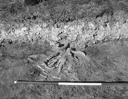
A group of antler picks deposited by Neolithic builders before they built the henge bank of Durrington Walls. Each alternating color of the black-and-white photographic rods indicate half-meter intervals.
The ditch around the henge, with its four openings, was dug out sometime in the years 2480–2460 BC. The work would have been desperately slow. When you use a pickax today, you swing it over your head and bring it down with huge force. That doesn’t really work with an antler pick. Experimental archaeologist Phil Harding has found that the best way of digging with an antler pick is not just to hack away indiscriminately at the solid chalk but to pick away at the small fissures and lever out the chalk in blocks. A deep, narrow hole can then be enlarged by undercutting its sides, causing the chalk to collapse. This works well for the first 10 feet or so. Deeper down, the fissures in the chalk run out and the rock is completely solid. Here the tip of the tine has to be hammered deep into the chalk until there is enough leverage to pull the pick handle upward and flake off an inch or two. We know that the deep chalk was dug out like this because we have found the holes made by hammering the tips of the picks into solid rock.
At Durrington Walls, this laborious process would have continued for more than five meters, down to the bottom of the ditch. Digging this by hand with antler picks was a Herculean undertaking, cutting near-vertical sides down to a depth of 5.5 meters then hauling baskets of shattered chalk up ladders to the top, and then carrying the rubble a further three meters up to the top of the bank.
The geophysical survey shows that the diggers dug the Durrington ditch in segments, each about 40 meters long. The segments look in plan like a string of sausages, with narrow strips between wider segments, showing where the work teams had to break through to join up. One ditch segment on the south side was started and then filled back in and re-dug in a slightly different place: another occasion where someone in charge changed their mind, or realized that the diggers had made a mistake.