Stonehenge a New Understanding (40 page)
Read Stonehenge a New Understanding Online
Authors: Mike Parker Pearson
Tags: #Social Science, #Archaeology

Andrew also found that the long foot unit could have been used at another henge enclosure, Mount Pleasant, in Dorchester,
25
where it could be the base measurement for the diameters of a set of concentric timber circles, known collectively as Structure IV within this henge enclosure. But it does not work for Woodhenge or the other timber circles at Durrington Walls.
In the 1920s, Maud Cunnington discovered that the six oval rings of Woodhenge, when measured along their long axes, had diameters that matched standard lengths in a different unit, which she identified as the short foot.
26
The long diameters of Woodhenge’s six rings are close to being a regular series of multiples of ten in short feet. When trying to duplicate Cunnington’s measurements from the published plans, however, the errors are large—between 21 centimeters and 88 centimeters. This may reflect inaccuracies of archaeological recording: In 2007, Josh found that one of the Cunnington postholes had quite definitely moved about 30 centimeters from where it was marked on her plan. Closer
analysis of Woodhenge’s plan reveals that it appears oval because it was, in fact, laid out as a pair of semicircles whose centers are about 3.8 meters (around 12 short feet) apart.
Turning back to Stonehenge, we recalled that Flinders Petrie estimated the inner diameter of the sarsen circle as 100 Roman feet (0.973 statute feet, very close to the short foot).
27
Although we could dismiss this observation—it wasn’t a measurement to the midline of the stones, and Stonehenge is obviously now known to be pre-Roman—it made us think about the use of the short foot of 0.96 statute feet. The best fit for the radius of the Q and R Holes and bluestone circle on top of them is 40.33 short feet. The bluestone oval at Stonehenge’s center is formed of two semicircles with centers 3.3 meters (10.25 long feet or 11.28 short feet) apart. Their radii are 20.16 short feet. Although not exact, the correspondence of the radii of these two bluestone settings with a short foot distance of 20 is reasonable. Perhaps measurements using short feet were employed at Stonehenge together with long feet.
We have had less success with the trilithons. The two arcs of the sarsen trilithons have centers 4.35 meters (14.87 short feet) apart. The semicircle of the giant trilithon and its two neighbors is 24.78 short feet in radius, while that of the northeast semicircle is 25.8 short feet.
Andrew can find no sign of such a system of measurement being in use among the monuments at Avebury. Although the use of a dual system—long feet and short feet—in the Stonehenge area is intriguing, it is difficult to understand why both systems were used together at Stonehenge itself.
There is plenty more to do on this subject. Were house plans measured out using a standard unit? What dimensions do we have for other timber circles elsewhere in Britain? Plans from archaeological excavations are likely to be more reliable for investigating ancient metrology than survey plans of standing monuments, such as stone circles, because what we see today may be the result of later phases of rebuilding.
16
__________
Today, archaeologists use a huge range of remote sensing techniques that early excavators, such as William Hawley, could not have dreamed of. As well as magnetometry, earth resistivity, magnetic susceptibility, and ground-penetrating radar, we can use airborne methods, such as infrared photography and LIDAR (laser mapping of micro-variations of the ground surface). We don’t have to rely just on our ability to pick up flints while walking across a plowed field or digging a hole. That said, we’re a long way from having any kind of X-ray vision to reveal everything beneath the ground, and we know that many sites simply don’t show up using any of these remote sensing methods.
Back in the 1940s, J. F. S. Stone had none of these fancy techniques. Field-walking, excavation, and looking in holes in other people’s gardens were the ways in which he searched for new sites. One of his interests was in tracking down the distribution of pieces of bluestone around the Stonehenge landscape. In 1938, he dug a trench in the wood known as Fargo Plantation, on the south side of the Cursus about half a mile northwest of Stonehenge. Some Boy Scouts had found bits of Early Bronze Age pottery in a rabbit scrape, and Stone wanted to know what else might be there. He excavated a small group of Early Bronze Age inhumation and cremation burials set within a small henge ditch only seven meters across, and in the ditch he found a chunk of bluestone.
1
He also knew that bluestone chippings had been found in other spots nearby. Richard Colt Hoare and William Cunnington had found chippings in three round barrows west of Stonehenge, one of them 300
meters west of Stone’s small henge. In 1947, Stone picked up eight more pieces from the surface of a plowed field east of Fargo Plantation, most of them from its northwest corner close to the south ditch of the Cursus, in the same area where William Young had found several bluestone chips on the surface in 1934.
2
Stone’s dig into the Cursus ditch here produced a piece of Welsh sandstone.
Stone concluded that, since at least two types of Welsh rock were present—rhyolite and micaceous sandstone—this scatter of bluestones near Fargo Plantation and the south side of the Cursus did not mark the spot where a single stone had been dressed
en route
to Stonehenge. Instead, he wondered if there might once have been a bluestone circle somewhere around the west end of the Cursus. Over the next half-century, no one showed any interest in following up Stone’s findings; the field in question returned to grass and no further attempts were made to look for what might have been the site of another Stonehenge.
But Colin Richards and I wanted to see if Stone was right. In 2006, a small team set out to dig about 150 test pits, each just one meter square, in the area where Stone and Young had made their finds. Geophysical survey in advance of the digging had shown no trace of any prehistoric features, but we knew that sockets for small bluestone uprights might be too small and shallow to show up as buried features. One of our geological experts is Rob Ixer, a specialist in the identification of bluestones. Colin was looking forward to his visit because the test pits had produced plenty of likely candidates to show him. Unfortunately, Rob was not immediately impressed: Most of Colin’s suspected bluestones were nineteenth-century railway ballast. However, Rob took the finds away for a closer look and reported back that nine of the stone chippings that Colin found at Fargo Plantation were indeed Welsh rhyolite. We had a result. In 2009 I returned with Josh and California Dave to dig more test pits, and the student team found another three pieces.
Our search for a lost stone circle in this area to the northwest of Stonehenge also included geophysical survey in 2006, resistivity carried out by Kate Welham’s students, and magnetometry by English Heritage. Survey in Fargo Plantation itself, where Stone had excavated his mini-henge, was out of the question because of the tree roots, which interfere with the results. The survey therefore covered that half of the field in
which we and Stone had found the chips, but we drew a blank. Some years later, however, two separate teams of researchers came up with tantalizing discoveries on either side of Fargo. West of the plantation, a geophysics team from Wessex Archaeology identified in 2009 a circular arrangement of some twenty-two holes, about 30 meters in diameter, on the northern edge of the site of the proposed new Stonehenge visitor center at Airman’s Corner. Because this was a commercial operation (for clients of English Heritage), the results were confidential and the find couldn’t be revealed to the public. Is this the site of the missing stone circle or did these holes hold wooden posts? Or is this just a circle of pits?
Without archaeological excavation it’s impossible to know when this circle was constructed and whether its pits once held timbers, stones, or nothing at all. Only when it is investigated by spade and trowel will we know whether it had anything to do with Stonehenge.
In 2010, a geophysics team from Birmingham University and Vienna’s Institute for Archaeological Prospection discovered a similar-sized circle on the east side of Fargo. This one did make the newspapers—“the first major ceremonial monument near Stonehenge that has been found in the past fifty years” claimed the finders, oblivious of the previous year’s discoveries at West Amesbury.
3
Although it was announced as being a timber circle, there is again no way of telling from the geophysical results whether the features recorded by the survey are decayed postholes, former stoneholes, or empty pits. Could
this
be our missing stone circle?
This circle encloses an already-known Bronze Age barrow, dating from five hundred years or so after Stonehenge, and there is no way of knowing whether it dates to before, during, or after the period at which the burial mound was constructed. Geophysics is a tremendously useful science but its results need to be carefully interpreted before conclusions are drawn and, in this particular case, only excavation can decide the matter.
Back on the trail of the possible stone circle at Fargo, Colin asked Rob Ixer to tell him more about the bluestone chippings from the Fargo field. Rob was puzzled that none of them was of dolerite (diabase in American English), the rock type of most of the Stonehenge bluestones. Just as intriguingly, these rhyolite fragments were definitely Welsh but of a slightly different kind to the rhyolite bluestones at Stonehenge. Two pieces of micaceous sandstone from Fargo are, as far as Rob can tell, the
same as the stones of this type at Stonehenge. What are these chips of stone doing in the Fargo field? Does this mean that there was once a bluestone setting somewhere around the west end of the Cursus? It may well be in the wood, inside Fargo Plantation itself, if it isn’t one of the two pit circles revealed by geophysics.
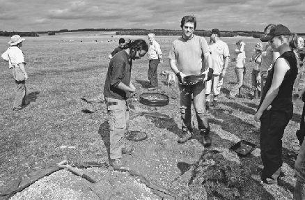
Students digging test pits near Fargo Plantation, south of the Cursus. Colin’s team here found small chips of bluestone as well as remains of the 1977 Stonehenge festival.
The Preseli Hills, where the Stonehenge dolerite originates, are an area of upland east of the seaside town of Fishguard and south of Cardigan. As the crow flies they’re about 140 miles west-northwest of Stonehenge. Dolerite is a medium-grained igneous rock that forms a series of rocky outcrops on Preseli; despite the “bluestone” name, it actually has a dark greenish color. In certain parts of Preseli it appears as an unusual variant called spotted dolerite (also known as preselite), in which the green rock is spotted with groupings of white quartz crystals.
In the early 1920s, Herbert Thomas showed that the Stonehenge spotted dolerite originates in the Preseli Hills.
4
More detailed chemical
analysis, published in 1991 by Richard Thorpe and Olwen Williams-Thorpe, narrowed down the geological source to an area about a mile across within the eastern part of the hills.
5
In 2006, Williams-Thorpe and colleagues published more results, showing that the closest match for most of the Stonehenge spotted dolerites is an outcrop called Carn Goedog on the northern slopes of Preseli.
6
Other outcrops, notably Carn Menyn (also known as Carn Meini), have chemical signatures close enough to indicate that they may also have been the source.
There is a range of other igneous rocks among the Stonehenge bluestones: rhyolite, rhyolitic ignimbrite (tuff), calcareous ash, volcanic ash, and altered volcanic ash. Among the five types of Welsh rhyolite at Stonehenge, Rob Ixer and his colleague Richard Bevins, of the National Museum of Wales, were able to pin down one of them—in a spectacular piece of geological fingerprinting—to a small outcrop in the Nevern valley, just north of Carn Goedog.
7
They now suspect that three of the other rhyolites come from that same outcrop, and that many or all of the other non-dolerite igneous rocks at Stonehenge derive from nearby outcrops in the valleys of the Nevern catchment, north of Preseli.
There are also two types of micaceous sandstone among the Stonehenge bluestones. The Altar Stone is of one type, and the other is represented by two stumps of former uprights. These stones were thought for a long time to have come from Paleozoic outcrops of Old Red Sandstone, possibly the Senni Beds around Milford Haven.
8
Scientists reasoned that megalith movers transporting the bluestones from Preseli to Milford Haven must have picked up these sandstone blocks along the way. From Milford Haven, the stones could then have been floated on rafts or in simple boats around Land’s End, along England’s south coast and up the River Avon to Stonehenge. Alternatively, the bluestones might have been floated across the Severn estuary to the Somerset Avon, transhipped to the upper waters of the Wiltshire Avon and then to Stonehenge. However, Rob and fellow geologist Peter Turner are sure that the Stonehenge sandstones are Devonian rocks that cannot have come from the Milford Haven area.
9
Instead, they suspect that possible sources for these sandstones may include the Brecon Beacons, about fifty miles due east of Preseli, as well as somewhere within west Wales.