The Indian Ocean (44 page)

We are seeing in all this widespread connections between parts of the British empire scattered all around the shores of the ocean, and in some cases going far inland. I have concentrated on connections to and from India, and for a very good reason. It was India which was the fulcrum of the ocean, both at this time and earlier and later, and consequently I have had to privilege the subcontinent. This was writ large during the nineteenth century, when India was indeed the jewel in the British imperial crown: the only place of which Victoria became Empress was India.
The great proconsul George Curzon put forward a vigorous late-Victorian statement of the centrality of India:
Without India the British Empire could not exist. The possession of India is the inalienable badge of sovereignty in the eastern hemisphere. Since India was known its masters have been lords of half the world. The impulse that drew an Alexander, a Timur, and a Baber eastwards to the Indus was the same that in the sixteenth century gave the Portuguese that brief lease of sovereignty whose outworn shibboleths they have ever since continued to mumble; that early in the last century made a Shah of Persia for ten years the arbiter of the East; that all but gave to France the empire which stouter hearts and a more propitious star have conferred upon our own people; that to this day stirs the ambition and quickens the pulses of the Colossus of the North [Russia].
20
The possession of India was vital not only in symbolic terms, but also for hard economics. As Pope vividly points out,
the health of the British imperial structure relied to a great extent on India's commercial relations with the world. Britain's trade deficit with Europe and America was balanced by India's trade surplus with the world economy, giving Britain positive balance of payment figures overall. This accounting relied on the ability of India to export produce....
Australia played a role here too, for the discovery of gold in the 1850s meant that this could now flow, in an intraimperial fashion, to India to finance the exports of Indian produce which before had necessitated sending gold from Britain. This situation continued into the twentieth century. Indian exports by 1910 were covering up to 50 per cent of Britain's trade deficit. During World War I Britain had a major problem. To cover the importation of American goods they had to keep gold stocks in London. However, gold was also needed in India to finance sending war materials to Britain. The British used their very widespread imperial connections to collect gold from many places: Japan, India, Hong Kong and South Africa, and also Australia. The bullion was minted into sovereigns in Australia and sent to India.
21
From about the end of the Seven Years War, in 1763, Britain faced no major challenge to her naval dominance in the ocean. The only remaining threat was 'piracy'. We noted earlier that it is not a simple matter to say who is a pirate, and who is an auxiliary of an established 'state' (see pages 126–7). As Mitchell noted perceptively, 'The same person might well be trader, fisherman, pirate and naval employee by turns.'
22
Even at the start of our period the situation concerning Europeans was still blurry. During the French revolutionary wars British naval forces in the Indian Ocean were stretched thin on occasion. The enemies who did best in this situation were not the official French frigates, but rather the more or less sanctioned privateers. The authorities in French Mauritius licensed twenty-five such privateers, and between 1793 and 1802 they took 200 prizes, while official frigates took only forty.
23
Early in our period European ships were still at risk from pirates, as Earl found in 1832. One pirate in Indonesia had a prahu with 150 men and several large guns.
The pirates who infest the Archipelago consist wholly of the inhabitants of the free Mahommedan states in Sumatra, Lingin, Borneo, Magindano, and Sulu; those natives who have remained uncontaminated by the detestable doctrines of the Arabs never being known to engage in the like pursuits. The Europeans who are unfortunate enough to fall into their hands are generally murdered, while the natives who compose the crews of the captured vessels are sold for slaves.
24
So also off the west coast of India, where the Angrias and Sidis in the late eighteenth century sometimes gave as good as they got when confronted by EIC craft. However, as European ships evolved into iron and steel monsters, a process we will cover in detail presently, their ships became less vulnerable. The Europeans could use steam gunboats, and exchange information using the electric telegraph. Now it was only local ships which were under threat.
The Europeans pursued a carefully graduated policy on this matter. Essentially they defined who were their allies or clients, and protected their ships, and indeed sometimes turned a blind eye to nefarious activities from such client states. It was the enemies of the clients who were subject to attack. This was well articulated by the leader of a 'pirates'' stronghold in Kathiawad, western India, in 1807. He lugubriously told the British, 'In these days, all merchants have taken to the flag and protection of the Honourable Company, and if I abstain from plundering them, where can I procure food, and if I continue I fall under the displeasure of the Company.'
25
Similar discriminatory policies were pursued by the Dutch and English in the Malay world, and by the Spanish in the Philippines, but I have chosen to use as a case study the British attack on what they defined as piracy in the Gulf in the early nineteenth century.
The people concerned were the Qawasim, a confederation of tribes who lived in al-Sir province, now part of the United Arab Emirates. Their main port was Ra's al-Khayma, north of Muscat, but they also controlled Sharja and, on the other side of the gulf, Linga. This grouping was in competition with Oman, further down the gulf. Early in the nineteenth century they even attacked EIC and Royal Navy ships with their formidable fleet of about sixty larger ships, several hundred smaller ones, and some 20,000 men.
26
By the second decade of the nineteenth century the British were becoming seriously concerned. There were economic matters: the Qawasim were hindering trade in the Gulf, or so they claimed, and competing quite successfully in trade between India and the Gulf. Nevertheless, Mumbai's trade with the Gulf actually rose threefold in the first twenty years of the century, which seems to make the hindering trade argument rather specious. Politics also played a part here. The British were becoming closer to Oman, with its valuable dependency of Zanzibar, under Sayyid Sultan. The British defined one party to a rivalry between two indigenous Gulf states as pirates, and acted accordingly. As Philip Francis said at the time in the House of Commons, 'whenever the Governor General and Council (of India) were disposed to make war upon their neighbours they could at all times fabricate a case to suit their purpose.'
27
Ra's al-Khayma was stormed and taken in December 1819, and a victor's peace imposed next month. Sayyid Said of Oman, who ruled from 1804 to 1856 (he moved to Zanzibar in 1832), had helped the British and now was rewarded. Oman received privileged treatment in the General Treaty of Peace of 1820. All Gulf traders were now to be subject to the new order. Friendly Arab ships had to carry a register setting out where they were going, how big the ships were, and how many arms they carried. This register, eerily reminiscent of the Portuguese cartaz of the
sixteenth century, was to be produced on demand to any British ship that they came across.
28
'Unfriendly' ships were confiscated.
The always quotable George Curzon explained what had happened. The situation in the Gulf was anarchical in the early nineteenth century.
Arab corsairs desolated its shores and swept its water with piratical flotillas; slave-hunting flourished; and security either of trade or dominion there was none. The hands by which this long-standing anarchy was subdued are also those by which present differences are composed, and maritime peace assured that is one of the most successful achievements of practical statesmanship. The pacification of the Persian Gulf in the past and the maintenance of the status quo are the exclusive work of this country; and the British Resident at Bushire is to this hour the umpire to whom all parties appeal, and who has by treaties been instrusted with the duty of preserving the peace of the waters.
29
He refers here to the way in which what the British called the Pirate Coast was transformed into the Trucial States, by which the various 'states' and tribal confederations of the Gulf were brought under British hegemony by means of signing 'truces'. These states were required to end the slave trade by sea, and to refrain from acting as 'irresponsible buccaneers' at sea. However, crucially, Curzon was quite clear that what happened inland was of no concern to Britain: its only interest was to safeguard trade.
The truce has not prevented, it was neither designed nor expected to prevent, warfare by land. These petty tribes exist for little else but internecine squabble, blood-feuds, puny forays, and isolated acts of outrage or revenge. With their internal relations Great Britain, who claims no suzerainty over Arabia, would have been foolish to interfere. All that she took upon herself to do was to secure the maritime peace of the Gulf....
30
This modulated approach to the area continued in force until oil entered the picture in the twentieth century.
Curzon is describing here one part of the way in which Europeans, and especially the British, were able to control the Indian Ocean. Steam ships, the Suez Canal and better ports were most important, but there also was the matter of mapping the ocean. It would be easy to assume that once John Harrison produced a chronometer in the 1770s which could be used to work out longitude there were no more problems, and European ships could navigate secure in the knowledge that they knew exactly where they were. In reality it was decades before even western ships achieved this sort of certainty. In 1786 Mrs Fay's ship was running short of provisions, but the captain said this was no problem, as they were near St Helena, where food could be obtained. Alas, it turned out they were still off the East African coast.
Right up to 1817, thanks to various errors and careless map-making, there appeared on standard charts of the Indian Ocean a fictitious island at about 28° S and 74° E, which in reality did not exist at all.
31
Well into the nineteenth century European sailors, just like their Arab predecessors, hoped to sight a known land or island in order to check their location. One example was St Paul and Amsterdam islands at 77° E and 37–38° S. These marked where ships using the roaring 40s either turned north to India, or kept on going east to Australia. They were used as such up to the 1860s by sailing vessels. But about this time improved navigation methods meant that ships bound for the Australian gold rushes now went further south to take full advantage of the roaring 40s.
32
Certainly navigation and map-making improved dramatically in the nineteenth century, so that in the terms used by Edward Said the Indian Ocean was constructed and 'known' by foreigners: knowledge and power coexisted in a symbiotic relationship. The British spent much time and effort on making accurate charts. Captain William Owen on behalf of the British Admiralty spent an arduous five years, 1821–26, in two ships charting the East African coast. The results of these and other expeditions were published in the many Admiralty Guides which are one illustration of the technological superiority of the Europeans at this time. Here and elsewhere they was a strong connection between this advance and the displacement of local traders and ships. In the case of the maps and guides, they obviously made navigation safer for those who could use them, which obviously was mostly Europeans. Local craft seldom had anyone on board who could read them, and also did not have the navigational equipment needed to take advantage of their directions.
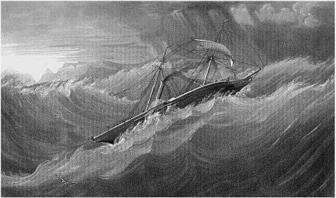
These charts and books were one way in which Europeans were able to overcome or at least ameliorate the effects of the deep structure elements I outlined in the first chapter of this book. Many of them no longer acted as iron constraints on what ships and people could do at sea. The monsoons, a strait jacket for millennia, now became largely irrelevant when confronted by steam ships. Poor harbours, or no harbours at all, were overcome by British engineers. Even distance was transformed by steam ships and the Suez Canal. As a capsule example, consider that even in the 1830s a return voyage from England to India took two years. By the 1850s steamers had cut this down to two to three months, and communication within a day became possible with the telegraph in the 1870s.
We have written extensively in previous chapters about the perils and risks associated with wind-propelled ships. Ships of whatever size which depended on the wind had obvious disadvantages, at least in economic terms, if not in aesthetic. They needed very large crews, so that the dhows of the western ocean were often overcrowded with crew, passengers, and traders all mixed together in each other's way, and indeed the distinction between the three was by no means clear cut.
In the first half of the nineteenth century there was considerable variation around the ocean. In some areas, such as in the Gulf and off southern Arabia, local ships did well. In other areas a pronounced dualism developed at this time, and this is before the major impact of steam ships. British sailing ships dominated long-distance trade,