The Source Field Investigations (47 page)
Read The Source Field Investigations Online
Authors: David Wilcock

In one case, Godfrey lost all radio and instrument contact for an hour and a half while flying through the Devil’s Sea, south of Japan, with only four hours of gas to go—and he was clearly terrified. He also said that when pilots head straight down the East Coast over the ocean, which is faster than sticking close to the land, they have to keep a very watchful eye on their instruments. Other pilots had already said the same thing, including Bob Durant on Barry Farber’s radio show. When Dick Cavett finally asked Godfrey, flat out, if this phenomenon warranted proper scientific investigation, he looked straight into the camera, and with total, deadpan seriousness, simply said yes.
5
5
This triggered a wave of new interest from scientists and engineers. One of them pointed out that the North and South Poles should also be included, as they fit the same geometric relationships very nicely. Sanderson published a diagram of these twelve “vile vortices,” as he called them, in the April 1971 issue of
Pursuit
, his journal. He then got a huge new burst of publicity when his classic article “The Twelve Devil’s Graveyards Around the World” appeared in a 1972 issue of
Saga
magazine. This triggered a scientific investigation by three Soviet researchers—Nikolai Goncharov, Vyacheslav Morozov and Valery Makarov—who published a paper about it in the USSR Academy of Sciences’ popular journal
Khimiya i Zhizn,
or
Chemistry and Life
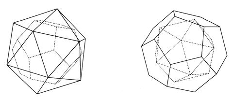
. Their paper came out in 1973, and was titled “Is the Earth a Large Crystal?” These three guys represented an interesting mix of talent—Goncharov was a historian, Morozov was a construction engineer and Makarov was an electronics specialist. Together, they realized that Sanderson’s twelve vortexes created an icosahedron when you connected the dots in three-dimensional space. This, again, is a roughly spherical geometric object that has twenty sides, each of which is a perfect equilateral triangle. They felt this was an energetic crystal structure of some kind that existed within the earth.
6
They referred to it as a “matrix of cosmic energy.”
7
Pursuit
, his journal. He then got a huge new burst of publicity when his classic article “The Twelve Devil’s Graveyards Around the World” appeared in a 1972 issue of
Saga
magazine. This triggered a scientific investigation by three Soviet researchers—Nikolai Goncharov, Vyacheslav Morozov and Valery Makarov—who published a paper about it in the USSR Academy of Sciences’ popular journal
Khimiya i Zhizn,
or
Chemistry and Life
. Their paper came out in 1973, and was titled “Is the Earth a Large Crystal?” These three guys represented an interesting mix of talent—Goncharov was a historian, Morozov was a construction engineer and Makarov was an electronics specialist. Together, they realized that Sanderson’s twelve vortexes created an icosahedron when you connected the dots in three-dimensional space. This, again, is a roughly spherical geometric object that has twenty sides, each of which is a perfect equilateral triangle. They felt this was an energetic crystal structure of some kind that existed within the earth.
6
They referred to it as a “matrix of cosmic energy.”
7
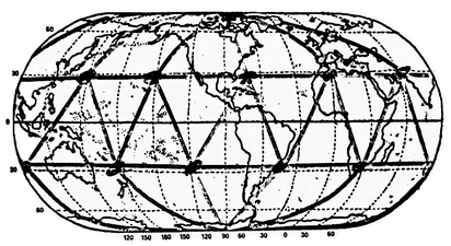
Ivan T. Sanderson discovered that most ship and plane disappearances occurred in twelve equidistant locations around the world, forming this geometric pattern.
The icosahedron, discovered in earth’s vortex points by Sanderson, can be geometrically inverted to form a dodecahedron, as we see here.
They also knew that when you turn the icosahedron inside out, you get its geometric opposite, called the dodecahedron—a twelve-sided object that looks like a soccer ball, where each of the twelve faces is a five-sided pentagon. They drew all the lines for where these geometries appeared over the surface of the earth, based on Sanderson’s twelve original points, and found a wealth of hidden treasures.
Many of the greatest earthquake-prone seismic fracture lines were directly on this grid. Undersea volcanic mountain ridges often lined up perfectly with the grid, including the Mid-Atlantic Ridge—as well as above-ground mountain ranges.
8
All of these effects could be the result of natural spin currents in the mantle, where this sideways force of gravity pushes the molten material into cyclical flow patterns. The highest and lowest atmospheric pressure zones also appeared in some of the areas where any three lines crossed—of which there were a total of sixty-two places. Again, this could be caused by gravitational force affecting the behavior of the atmosphere—via spiraling currents not yet acknowledged in mainstream science. These vortex areas formed the center points for major ocean currents and whirlpools as well—showing the gravitational effects upon the flow patterns of water. The areas of highest and lowest geomagnetic gauss strength fit neatly within this geometry.
9
Significant concentrations of ores and petroleum also appeared in these areas. Animals naturally followed these paths in their migrations. Unique wildlife appeared in these areas—and anomalies in the gravitational field.
10
Once the dodecahedron was added to Sanderson’s original discovery, Russian scientists discovered that over 3,300 different ancient sites were built on this grid.
Best of all, advanced prehistoric cultures and ancient civilizations also showed up in these spots. In fact, fully 3,300 different sacred complexes and ancient monuments, often built out of massive stones, appeared on this grid. This included the Great Pyramid in Egypt, the ruins of Great Zimbabwe in central Africa, Stonehenge and Avebury in England, the pyramids of China in the Xian province, the Kunoonda stone circle complex in Australia, the ruins of Nan Madol at Pohnpei, the mysterious stone heads of Easter Island, Machu Picchu in Peru, the pyramids of the Sun and Moon at Teotihuacan in Mexico, the Four Corners area of the Hopi in the American Southwest including Sedona, Arizona, and many more.
11
This is very compelling evidence that the ancients built their gigantic stone monuments in the places where it was the easiest and also the most coherent, thereby making it much easier to shield gravity—and also get much more powerful healing effects as well. It may even have been possible to use these points for time travel if you knew when the right planetary alignments would occur.
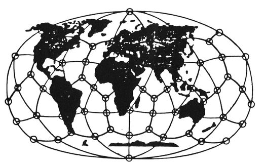
William Becker and Bethe Hagens further refined and enhanced the work of the Russian scientists, drawing lines that connected more of the geometric points together—and created what may be the most advanced visualization of the Global Grid yet. In their classic work
The Planetary Grid: A New Synthesis,
two different grid-related aircraft cases were given, where sudden and unpredictable course changes occurred without the pilots’ control that fit the structure of the grid lines.
12
The first involved KAL 007, out of Anchorage, Alaska, on September 1, 1983. The second was KAL 902, heading from Paris to Anchorage on April 20, 1978. Both these flights occurred during significant holidays in two different cultures : KAL 007 happened during a major Hindu feast for Vishnu, and KAL 902 took place during Good Friday/Passover.
13
It is possible that certain ancient holidays were chosen for a reason—the earth’s alignment, as we move through the seasons, may have given atoms and molecules on earth a little extra kick to get over the light-speed boundary on these special days. Obviously, much more research is needed to confirm this speculation—and some holidays do not appear on the same day from one year to the next—but it’s an interesting possibility.
Ley Lines And BeyondThe Planetary Grid: A New Synthesis,
two different grid-related aircraft cases were given, where sudden and unpredictable course changes occurred without the pilots’ control that fit the structure of the grid lines.
12
The first involved KAL 007, out of Anchorage, Alaska, on September 1, 1983. The second was KAL 902, heading from Paris to Anchorage on April 20, 1978. Both these flights occurred during significant holidays in two different cultures : KAL 007 happened during a major Hindu feast for Vishnu, and KAL 902 took place during Good Friday/Passover.
13
It is possible that certain ancient holidays were chosen for a reason—the earth’s alignment, as we move through the seasons, may have given atoms and molecules on earth a little extra kick to get over the light-speed boundary on these special days. Obviously, much more research is needed to confirm this speculation—and some holidays do not appear on the same day from one year to the next—but it’s an interesting possibility.
In the twentieth century, Sir Alfred Watkins found that a huge number of architectural sites, from all different historical periods, appeared throughout England on straight-lined paths called ley lines. One in particular cut almost horizontally across southern England.
I was delighted to find a BBC article in 2005 that soberly discussed these mysteries.
“[Ley lines are] alignments and patterns of powerful, invisible earth energy said to connect various sacred sites, such as churches, temples, stone circles, megaliths, holy wells, burial sites, and other locations of spiritual or magical importance.”
(Harper’s Encyclopaedia of Mystical and Paranormal Experience)
. . . It is true that more “paranormal” activity is evidenced in these areas [including hauntings] . . . effects of this type of energy are said to be similar to those of static electricity: feelings of “tingling” on the skin and hairs standing on end. . . . A phenomenon often reported during investigations is that of technical equipment behaving erratically. . . . Major prehistoric structures of higher importance can frequently be found to occupy locations where two or more leys intersect with each other.
14
At the end of this article, there is a disclaimer saying it is “usergenerated content” that does not represent the views of BBC Gloucestershire—just so there is no confusion. All of the effects they mentioned are a perfect match with what we’ve been learning about the Source Field.
I was also greatly inspired by an article from Joseph Jochmans entitled “Earth: A Crystal Planet?,” which appeared in a 1996 issue of
Atlantis Rising
, and features some of the points I’ve already mentioned above. Jochmans revealed that many ancient cultures around the world had a unique focus on these ancient, straight lines. The Irish called them fairy paths. The Germans called them holy lines. The Greeks referred to them as the Sacred Roads of Hermes. The ancient Egyptians called them the Pathways of Min. The Chinese called them
lung mei,
or dragon currents—and believed that placing stones, trees, temples, houses and pagodas along these lines would directly help the earth, as part of the ancient practice of Feng-shui. The earth was treated in much the same way as the body would be healed—through the acupuncture lines. The idea of the
axis mundi
also fits in very nicely. If you have a major energy vortex in a particular land, that obviously would become the focal point for everyone—if enough people knew about it and could make use of its benefits.
The Australian Aborigines called them dream paths—and would do seasonal walkabouts along these lines to reenergize the life force in those regions. They would map out the dream lines on boards called Turingas, and could locate game animals and predict the approach of storms by meditating on the lines. Ancient Polynesians called them
te lapa
, or “lines of light,” and could apparently see them as visible, luminous lines in the ocean that they used for navigation. The residents of Easter Island and Hawaii called them aka threads, and built the stone heads and sacred Ahu platforms in Hawaii to harness the
mane
, or “life power,” from these lines. The Incas organized their entire civilization along ceque lines, building wacas or sacred centers along the way—all of which converged at the Pyramid of the Sun in Cuzco.
The Maya built raised white roadways called Sacbes that followed the lines with perfect straightness, going right through the swamps, to connect their pyramid complexes together. Medicine wheels and kiva circles in western North America are also found in straight-line arrangements, and the Mound Builders in the Midwest and East Coast regions of what is now the United States also left their structures in curious alignments—again seemingly to harness the powers of this grid, and the coherence it produces. Jochmans also said that Native American shamans often speak of healing energies from the earth they call Orenda, Manitou and other such names. Interestingly, Jochmans also claimed that the Hopi elders said the earth was like the back of a spotted fawn. As the fawn gets older, the spots change positions—and new points appear.
15
Geometric Expansion of Earth15
A NOAA scientist named Dr. Athelstan Spilhaus published a paper in 1976 proving the Hopi may have been absolutely right. Spilhaus, who passed away in 1998, was a highly decorated scientist, a genius inventor and the author of a syndicated comic strip. He developed the “bathythermograph,” a device for submarine detection that was vital in helping crush Hitler in World War II.
16
Spilhaus also was the inventor and research director of the top-secret Project MOGUL weather balloon project, which was officially said (in 1994) to have been what really crashed at Roswell.
17
Therefore, Spilhaus’s credibility is essential to the alleged UFO cover-up.
16
Spilhaus also was the inventor and research director of the top-secret Project MOGUL weather balloon project, which was officially said (in 1994) to have been what really crashed at Roswell.
17
Therefore, Spilhaus’s credibility is essential to the alleged UFO cover-up.
Other books
Zero-G by Alton Gansky
State of Decay (Omnibus (Parts 1-4)) by Martinez, Peggy
Hosker, G [Sword of Cartimandua 10] Roman Hawk by Griff Hosker
Sex Beast by Bourgoin, Stéphane
Assassin Affairs by Smith, R. S.
Dark Universe by Daniel F Galouye
The Curse of Sangrook Manor by Steve Thomas
Rest For The Wicked by Cate Dean
Gold Boy, Emerald Girl by Yiyun Li
So I Tamed a Texan by Lowe, Kimberly