Maphead: Charting the Wide, Weird World of Geography Wonks (11 page)
Read Maphead: Charting the Wide, Weird World of Geography Wonks Online
Authors: Ken Jennings
Tags: #General, #Social Science, #Technology & Engineering, #Reference, #Atlases, #Cartography, #Human Geography, #Atlases & Gazetteers, #Trivia

Translation: no, there’s not a single documented case of a pirate drawing a map to buried treasure. This was a trope invented by the likes of Edgar Allan Poe and Robert Louis Stevenson, not Captain Kidd and Blackbeard. I make a mental note not to mention this at my son’s upcoming birthday party, for which a buccaneer theme is planned. I’m still reeling from my geographic faux pas of a few months back—when I told my kids that there’s no land at the North Pole the way there is in the Antarctic, just water and sea ice, it led to some uncomfortable Santa-related follow-up questions. Sometimes careful cartography is good for the imagination, but other times you’d rather have the mystery.
The Map Division’s visitors come from all over the world. Recently, scholars flew in from Beijing to look at nineteenth-century plans of the Chinese capital, because Washington had better maps than anything they could find in China. In 2001, a Japanese research group stopped by the library to see what they could find on Ino Tadataka, the legendary shogun-era surveyor whose team produced the first modern map of Japan in 1821. That map was later lost in a fire, and modern scholars had been able to locate only 46 of his map’s 214 tatami-mat-sized pages in Tokyo’s Diet Museum. They were shocked to find that 207 pages—nearly a complete set—had been gathering dust in the Geography and Map Division for decades and soon secured a quarter of a million dollars from the Japanese government to scan and restore them. The final map was finally exhibited in a Nagoya baseball stadium, laid out neatly along the right-field line. Thirty-five thousand people filed by to look. “This collection is full of gems like that, just waiting to be discovered,” says Hébert. In fact, there’s no catalog at all for the vast majority of the pre-1970 material here; there’s just too much of it. Millions of maps will sit unseen until someone looks for them.
Sometimes the foreign visitors are officials looking to settle—or start—a border dispute. It might be a South Korean delegation hoping to discredit Japanese claims to some tiny islets in the Sea of Japan or a group of Congolese and Ugandan bureaucrats wondering where
exactly in Lake Victoria their nations meet. “They had gone to Brussels, they’d been to London, couldn’t find the official maps. We had ’em,” says Hébert proudly. In the late 1970s, Chile and Argentina were locked in a dispute over who controlled the eastern end of the Beagle Channel, a narrow strait running between the islands of Tierra del Fuego. This wasn’t just an obscure issue of national pride for Chile, which would lose its only access to the Atlantic Ocean if Argentina’s version of the border was drawn. The ruling junta in Argentina at the time seemed ready to go to war over the boundary, refusing to accept an International Court of Justice ruling for Chile and even preparing a military invasion of the contested islands for December 1978. At the eleventh hour came a diplomatic development straight out of the sixteenth century: the Vatican intervened, and both nations agreed to let the pope draw the boundary line. During the height of the conflict, Argentine and Chilean delegations spent months sitting at tables at opposite sides of the Geography and Map Division reading room like warring cliques in a high school cafeteria. They would request the same maps of Tierra del Fuego in turn and study them carefully, never acknowledging the enemy across the room. “We’re neutral ground,” claims John Hébert, but it might be more accurate to say that, for a few months, the border between Chile and Argentina ran north, right through the basement of 101 Independence Avenue in Washington, D.C.
Boundary lines can arouse stronger feelings than perhaps any other feature on a map. Marking property was the purpose of many of the earliest surviving maps, and boundary markers—piles of rocks, for example, the human equivalent of a dog peeing on a tree—probably go back millennia earlier. In medieval Europe, the surveyor was a hated figure, something like the “revenuer” in mountain moonshiner lore: a corrupt lackey always looking to stick it to poor farmers. His new map might take away part of your field, or it might raise your rent or your taxes. In Poland, surveyors were so dreaded that even death couldn’t end their menace. The flickering lights of swamp gas—what we call will-o’-the-wisps—were said to be
the ghosts of dead mapmakers
wandering the marsh by night. Better finish your cabbage, kids, or the
surveyor
will come and get you!
A nice thick border and a carefully chosen color scheme can serve to unify a nation, as on those Victorian maps in which every far-flung corner of the British Empire was always the same uniform
pink
, to impress on generations of schoolchildren the constancy and reach of the Crown—the “pink bits,” students called the empire.
*
Map boundaries also define, with a simple stroke of the pen, who
isn’t
on our side: an enemy to guard against or even territory we might take back someday. These aren’t just lofty scholarly concerns. Google fields so many complaints about the national borders on its maps that it’s started delivering
localized versions
to different users: an Indian user might see a border in one place while a Pakistani user sees it somewhere else, and everyone stays contented in their own little cocoons of geographic superiority. In 2006, when the Israeli education minister, Yuli Tamir, announced that textbook maps of Israel would put a border around the West Bank, rather than depicting it as undemarcated Israeli territory, hard-line rabbis announced that
God would strike her down
for her blasphemy. You can’t explain this all away as mere political posturing; it’s genuine offense. The clarity and simplicity of the lines on a map make them powerful symbols.
Borders have fascinated me since childhood: I remember staying very alert on family vacations so I could register the
exact moment
our 1979 Mercury Zephyr crossed the line between, say, Washington and Oregon. To this day, I like to see borders when I travel; many give up secrets in person that you can’t see on the map. You know that seemingly straight line of Manitoba’s western border, the one that makes Saskatchewan such an eye-catching trapezoid on a globe? It’s actually a pixelated zigzag, running maybe twenty miles north at a time before taking an abrupt one-mile “stair step” to the west. The Belgian town of Baarle-Hertog is even more intriguing: it’s made up of no fewer than twenty-six separate pieces of Belgium sitting, thanks to a complicated series of medieval treaties between two warring dukes, in the middle
of the Netherlands. Some of these little bits of Belgium have little bits of the Netherlands inside
them,
leading to an impossibly intricate border that divides some village homes in half between the two nations. Your nationality depends on where your front door is, and residents have been known to “emigrate” by moving their door every time the tax laws change. When bars and restaurants in the Netherlands close, landlords just move their tables onto the Belgian side of their establishment and keep on serving.
In search of the most exotic border crossing of all, I insisted to my wife that our trip to Thailand last year should include a side trip to the Angkor temples of Cambodia—by bus. Why? Because I’d always wanted to find out what happens when you cross between a drives-on-the-left country (like Thailand) into a drives-on-the-right one (Cambodia). Would there be an overpass? A roundabout? An endless stream of hilarious traffic accidents? We were disappointed to learn that the border between Aranyaprathet, Thailand, and Poi Pet, Cambodia, is a traffic-free no-man’s-land with only the occasional semi pulling through after it clears customs. Maybe most people wouldn’t go to the length of a four-hour bus trip through the Thai jungle, but I know I’m not the only one who gets this liminal thrill from standing on borders. Four Corners Monument, where Utah, Colorado, Arizona, and New Mexico meet, is in the middle of nowhere. But two hundred thousand visitors make the trek each year to straddle a small round plaque and enjoy whatever the strange rush is that comes from being in four states at once.
*
Borders may start out as arbitrary, but they don’t stay that way for long. The British travel writer
Mike Parker has noted
that the Earth, seen from orbit, is no longer a borderless, utopian “big blue marble”: where nations meet, so do their agendas and policies. From miles above the Earth, you can see the straight line where heavily forested western Russia meets the cow pastures of eastern Finland or where a stretch of
Montana grassland meets irrigated strips of farm country in southwest Saskatchewan. The most dramatic example is the heavily militarized “demilitarized zone” between the two Koreas, just a half hour’s drive north of Seoul, where I grew up. By day, the rift in the divided peninsula is almost invisible from space, but by night, the cities of South Korea are brightly lit, while isolated, agrarian North Korea is abruptly dark, as empty as the remotest stretches of Siberia or the Sahara. The distinct line between light and dark looks like a power outage moving across a cityscape grid by grid, except that this blackout has been going on for sixty years. By night, South Korea isn’t a peninsula. It’s an island.
Borders may divide us, but, paradoxically, they’re also the places where we’re nearest to one another. Borders on a map may start out as a useful way to separate Us from Them, but then they become symbols of our own complacency; by their very existence, they dare us to cross them. The breaching of a border doesn’t have to be the result of an invading barbarian horde; when the Berlin Wall collapsed in 1989, it was gleefully sledge-hammered into the past by those on both sides of it. Even Chile and Argentina signed a Tratado de Paz y Amistad (“Treaty of Peace and Friendship”) at the Vatican in 1984, ending the century-long Beagle Channel conflict for good. “We’ll meet on edges soon,” as Bob Dylan once sang.

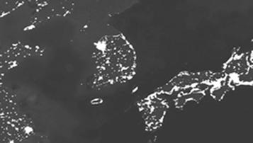
South Korea’s secret double life: peninsula by day, island by night
John Hébert is also the chairman of the U.S. Board on Geographic Names, a federal body created in 1890 by President Benjamin Harrison to standardize American place-names. For more than a century, the board has worked to sort out tangles of inconsistency and confusion that can plague even some of the nation’s most prominent spots. Take
the Mount McKinley controversy
: in 1975, the state of Alaska officially changed the name of North America’s highest point to “Denali,” the native Athabascan name for the peak. But the Board on Geographic Names has been repeatedly stymied in making this change official, thanks to the congressional delegation of Ohio, William McKinley’s home state, which has been introducing anti-“Denali” clauses into appropriations bills for thirty years. Occasionally the board makes blanket changes, as in 1967, when 143 occurrences of America’s direst racial slur were globally replaced on maps with the word “Negro.” (In a similar move, “Jap” later became “Japanese.”) This didn’t solve every uncomfortable map issue, of course. The USGS quadrangle maps are still littered with Dago Springs and Chink Peaks and Polack Lakes, and it’s not as if “Dead Negro Creek” is a huge improvement over the alternative anyway. But the board’s goal is typically historical correctness, whether that aligns with political correctness or not. In 1983, for example, it returned the name “
Whorehouse Meadow
” to the map of Fish Lake, Oregon, after determining that the limp 1968 replacement, “Naughty Girl Meadow,” was a bowdlerization concocted by embarrassed park officials. Today, says Hébert,
the board’s workload consists mostly of hundreds of requests to name things after Ronald Reagan. Between McKinley and Reagan, we’re apparently spending a
lot
of time and paperwork on the iffy cartographic legacies of two-term Republicans.
As long as I’ve loved maps, I’ve been an enthusiastic toponymist: a student of place-names. Maps that aren’t dotted with text look barren and lonely to me—what could be more soulless than one of those grade-school outline maps of a region with only a few sad oil derricks or ears of corn drawn on it to depict industry or agriculture? Those are the abominations that make kids hate geography. Names are the alchemical infusion that bring a map to life. There may be poetry in the curl of a coastline, but there’s
personality
in a Humpty Doo, Australia, or Oaxaca, Mexico, or Chililabombwe, Zambia. The great Flemish cartographer Abraham
Ortelius
evidently agreed with me. In his 1570 atlas,
*
he labeled his imaginary southern continent of Terra Australis with
tantalizing place-names
like “Land of Parrots,” “Cape of the Good Signal,” and “Sweetest River.” No one had ever actually
been
to these nonexistent places, but hey, it was either that or leave an entire landmass suspiciously naked.
†