The Attacking Ocean (3 page)
Read The Attacking Ocean Online
Authors: Brian Fagan
Tags: #The Past, #Present, #and Future of Rising Sea Levels

An ascent of 122 meters is a long way for oceans to climb, but climb it they did, most of it with breathtaking rapidity by geological standards, between about fifteen thousand years ago and 6000 B.C.E. Most of the ascent resulted from powerful meltwater pulses that emptied enormous quantities of freshwater from ice sheets on land into northern waters and around Antarctica. This was not, of course, the first time that such a dramatic rise had transformed an ice-bound world, but there was an important difference fifteen millennia ago. For the first time, significant numbers of human beings, perhaps as many as hundreds of thousands of them, lived in close proximity to the ocean.
Some traveled offshore. Fifty thousand years ago, even while the late Ice Age was at its height, small numbers of Southeast Asians had already ventured into open tropical waters to what are now Australia and New Guinea. Well before twenty thousand years ago, people were living on the islands of the Bismarck Strait in the southwestern Pacific.
2
These voyages took place long before melting ice sheets and rising sea levels transformed the Ice Age world of
Homo sapiens.
WE LIVE IN a rapidly warming world, where human activities now play a significant part in long-term climate change and have done so since the Industrial Revolution, when fossil fuels like coal came into widespread use. It’s hard for us to imagine just how different the world was twenty-one thousand years ago. Much of it lay under thick ice. Two huge ice sheets covered virtually all of North America, from the Atlantic to the Pacific. The Cordilleran ice sheet, centered on the Rockies and western coastal ranges, mantled 2.5 million square kilometers. The enormous Laurentide ice sheet lapped the Cordilleran in the west and covered over 13 million square kilometers of what is now Canada. It was nearly 3,353 meters thick over Hudson Bay. Its southern extremities covered the Great Lakes and penetrated deep into today’s United States. The Greenland ice sheet was 30 percent larger than today. Another smaller ice sheet linked it to the northern margins of the Laurentide.
In northern Europe, the Scandinavian ice sheet extended from Norway to the Ural Mountains over an area of 6.6 million square kilometers, may even have reached Spitsbergen, and flowed over much of the north German Plain. A smaller ice sheet covered about 340,000 square kilometers and reached halfway down the British Isles. Glaciers descended close to sea level in the Southern Alps. In Siberia and Northeast Asia, ice extended over at least ten times the area of the British ice sheet. Extensive ice sheets mantled the Himalayas.
Figure 1.1
Map showing approximate extent of ice sheets and lower sea levels during the late Ice Age.
The Antarctic ice sheet was about 10 percent larger; seasonal sea ice extended eight hundred kilometers out from the continent. There were important ice sheets on the Andes Mountains, in South Africa, southern Australia, and New Zealand. Twenty-one thousand years ago, there was two and a half times as much ice on land as there is today. Of that, 35 percent was on North America, 32 percent on Antarctica, and 5 percent on Greenland. Today, 86 percent of the world’s continental ice is on Antarctica, 11.5 percent on Greenland.
There was so much water locked up in glacial ice sheets and sucked out of the oceans that global sea levels were up to 122 meters below those of today. These much lower sea levels changed the shape of entire
continents. Perhaps most significant historically was the bitterly cold and low-lying Bering Land Bridge that linked Siberia and Alaska, a natural highway that brought the first humans to the Americas. Dry land joined islands in Southeast Alaska and the Pacific Northwest of North America. Much farther south, San Francisco’s Golden Gate channel was a narrow tidal gorge with fast-moving rapids. Continental shelves extended some distance off the Southern California coast, leaving but eleven kilometers of open water between the mainland and the Channel Islands close offshore.
On the other side of the Pacific, low sea levels joined the Japanese islands to Sakhalin Island in the north and brought them much closer to the Chinese and Korean mainland. In China, major rivers like the Huang He in the north and the Yangtze in the south flowed through incised, narrow valleys rather than broad floodplains. Rolling plains stretched far into the distance off Southeast Asia. Only short stretches of open water separated the mainland from Australia and New Guinea, which were a single landmass, now covered by the shallow Arafura Sea.
The configuration of the Indian Ocean was much different from today. Bangladesh lay far above sea level by modern standards, incised by the Ganges and other rivers that flowed much more rapidly to the sea. Sri Lanka’s twenty-nine-kilometer-long Rama’s Bridge, now a chain of limestone shoals, was a land bridge to India. The Persian Gulf was dry land, an arid landscape bisected by a narrow gorge that drained the highlands and plains at its head.
Had one looked down from a satellite at Europe and the Mediterranean eighteen thousand years ago, one would have surveyed unfamiliar landscapes. Continental shelves extended far into the Bay of Biscay. You could walk from Britain to France, had you possessed a canoe to carry you across an enormous estuary that carried the waters of the Rhine, Seine, and Thames Rivers of today. The southern North Sea was a land of shallow lakes and marshes. The Mediterranean was far smaller, its narrow entrance at the Strait of Gibraltar scoured by fast-running currents. The northern Aegean Sea ended in a high barrier that isolated what is now the Black Sea from the ocean. The Euxine Lake, formed by
glacial and freshwater runoff from the north, lay behind the natural berm. On the other side of the Mediterranean, the arid Nile delta with its sand dunes extended far into what is now open sea.
Everywhere large rivers like the Thames and the Rhine had lower courses and estuaries far different from those of today. The Nile flowed through a twisting, narrow gorge, where the annual flood for the most part remained close to the river channel rather than spilling over a wide floodplain as it did until the building of the Aswan Dam. In the Americas, the St. Lawrence River did not exist; it was under the Laurentide ice sheet. The Mississippi and Amazon Rivers cut far below their modern gradients, with almost none of the ponding and wetland formation that developed as sea levels rose.
Rapid, natural global warming transformed the late Ice Age world into what was effectively an entirely different place in less than ten thousand years. Within this brief time frame, the world’s sea levels rose 122 meters.
EUSTACY AND ISOSTASY: the words used to describe sea level changes glide easily off the tongue, but they mask very complex and still only partially understood geological processes. What does cause the world’s sea levels to rise and fall? Isostatic changes result from local upward and downward shifts in the lithosphere, the uppermost layers of the earth. Such factors as earthquake activity and shifts of tectonic plates far below the earth’s surface are important contributors to sea level change. Subsidence in river deltas, changes in glaciers, even sediment compaction—anything that adds to or subtracts from the weight of the earth’s crust—all can cause isostatic sea level rises, such as are common in places like Shanghai.
3
Eustatic, global sea level rise is completely different, a measure of the increase in the volume of water in the oceans expressed as a change in water height. Everyone knows that water expands as it heats. When the earth’s atmosphere warms, the ocean absorbs much of the increasing heat and its waters swell. Thermal expansion is the major cause of global sea
level rise since the 1860s, when the Industrial Revolution with its promiscuous use of fossil fuels added more carbon and other pollutants to the atmosphere—in other words, when humanly caused global warming began. At present, eustatic sea level rise advances at a rate of about two millimeters a year if calculated on an average of the past century. Over the past fifteen years, however, the averaged rate is around three millimeters a year, apparently a direct, accelerated response to global warming.
In recent years, we’ve learned a great deal about the world’s glaciers, thanks to satellite technology. We can now measure the elevation of glaciers, their growing and shrinking masses from space with satellite technology, a task hitherto accomplished by arduous fieldwork on the ground. We can also measure the velocity of moving ice and establish the grounding points of glaciers. All of this gives us a more complete overview of the world’s ice. The new portraits show that the Antarctic and Greenland ice sheets have contributed only a tiny proportion to annual sea level rise—until recently. However, ice sheets are now contributing
double the amount of water they did in the recent past. All the signs are that the rate is accelerating, perhaps dramatically.
4
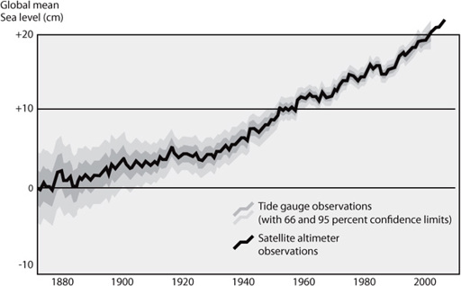
Figure 1.2
A global average of tide gauge data from 1870 to 2000. The new satellite altimeter data is superimposed from 1990. Data from both sources is very similar, chronicling a more rapid sea level rise since 1990. Courtesy: NASA.
Glaciers retreat most rapidly when they end in water. The Mendenhall Glacier near Juneau has retreated five kilometers since 1760 and a kilometer since 2000. Muir Glacier in Glacier Bay has receded ten kilometers since 1941, the Columbia Glacier in Prince William Sound by thirteen since 1981. The general retreat contrasts dramatically with that of the Little Ice Age (ca. 1350 to 1850 C.E.), when Alaska’s mountain glaciers not only thickened but also advanced.
The Greenland ice sheet covers 4,550 million square kilometers. If this were to melt completely, global sea levels would rise by seven meters. Recent estimates using a variety of high-technology measurements and satellite data place the annual loss of Greenland ice at about 96 cubic kilometers in 1996, and almost three times that, at 290 cubic kilometers a year, in 2006. Most of this acceleration is occurring in the southernmost glaciers, but the melting is gradually moving northward. Were the entire Greenland ice sheet to melt, which has happened in the remote past, what is now a frozen continent would become an archipelago of islands surrounding a central sea—until crustal adjustments caused the continent to rebound from the weight imposed on it by the ice.
Antarctica at the other end of the world is a vast desert continent, 98 percent of which is covered with ice. Until about 2000, the amount of Antarctic ice was slowly increasing. But recent satellite measurements show that the ice sheets are now losing mass. The East Antarctic ice sheet lies above sea level and is relatively stable. If it were to melt, the resulting sea level rise would be in the order of fifty meters. Much of the West Antarctic ice sheet is aground on the seabed, where changing ocean temperatures affect the stability of its foundations. When these decay, the upper parts of the ice sheet can detach and move seaward. Such melting occurred at the end of the last Ice Age and may well occur again in the near future. Should the entire West Antarctic ice sheet melt, world sea levels would rise by about five meters. If the sheet were to vanish within twelve hundred years, the ocean would climb about thirty to fifty centimeters per century. A five-hundred-year meltdown would cause sea level rises of as much as one hundred centimeters a century.
Predicting sea level changes is a game of geological poker. Unfortunately it is nearly impossible to establish whether changes in ice sheets are mere decadal events, part of normal fluctuations, or something that portends much more dramatic changes in the future. Many experts believe that a two-meter rise by 2100 should be the basis for future planning. Geoscientists Orrin Pilkey and Rob Young believe that “coastal management and planning should be carried out assuming that the ice sheet disintegration will continue and accelerate. This is a cautious and conservative approach.”
5
Pilkey and Young are sober voices in what often becomes a morass of alarmism and sensationalist headlines. Unfortunately, impending (if probably fictional) climatological catastrophe makes for headline news.
WHAT, THEN, DO we know about sea level rise since the end of the Ice Age? So many local factors are involved that it’s hard to provide anything more than a general portrait of global sea level changes over the past fifteen thousand years—and even then the experts disagree. Here’s a generalized framework, based on many data sources, which will provide a reference point for later chapters.
6
When the great thaw began, ice sheets retreated precipitously by geological standards. Enormous volumes of meltwater cascaded into northern waters, much of it in dramatic accelerations in sea level rise (often called “pulses”) recorded in Caribbean corals and other sources. There were at least four major pulses, the first about 19,000 years ago, when the sea rose between ten and fifteen meters within a mere five centuries. Another major meltwater release, most likely from North American ice sheets, came between 14,600 and 13,600 years ago. This time the sea level rose between sixteen and twenty-four meters. These major sea level rises came before the onset of a 1,300-year cold snap, the so-called Younger Dryas of 10,800 to 9500 B.C.E. (named by geologists after a polar flower), when sea level rise slowed, only to resume sharply with another meltwater pulse between 9500 and 9000 B.C.E. A fourth meltwater pulse between 6200 and 5600 B.C.E. brought a minor rise, perhaps a meter or so.