The Attacking Ocean (5 page)
Read The Attacking Ocean Online
Authors: Brian Fagan
Tags: #The Past, #Present, #and Future of Rising Sea Levels

Tropical cyclones are a major hazard in many parts of the world, notably in the western Pacific and the Bay of Bengal. Low-lying Bangladesh is basically a huge river delta at the head of the bay, where tropical cyclones breed, cover large areas, and move northward into the funnel created by the coasts on either side of the ocean.
We are already reaping a whirlwind of vicious assaults by an ocean that once lay 122 meters below today’s threatened shorelines. Billions of people are at risk from an attacking sea. Our future will be challenging, even before one factors in the ever-present threat of earthquakes and tsunamis. As history shows us, our vulnerability to an encroaching and often aggressive ocean has increased exponentially, especially since the rapid population growth of the Industrial Revolution. While as recently as eight thousand years ago, only a few tens of thousands of people lived at risk from rising waters—and they could adapt readily by upping stakes and moving—today millions of us live in imminent danger from the attacking ocean and from the savage weather events that await in a warmer future.
There is one knows not what sweet mystery about this sea, whose gently awful stirrings seem to speak of some hidden soul beneath.
—Herman Melville, 1851
The nine millennia between fifteen thousand and six thousand years ago saw complex human adjustments to rising seas, but also witnessed major shifts in people’s day-to-day lives. Ancient human societies living by seacoasts and lakes focused heavily on fishing, sea mammal hunting, and fowling. Many groups lived in such food-rich environments like northern Europe, Southeast Asia, and parts of the South African coastline, dwelling at the same locations for generations. In many parts of the world, large Ice Age animals became extinct. People turned to smaller game and to plant foods for much of their diet as the climate changed the world around them.
Nowhere were the environmental changes more profound than in northern Europe. For tens of thousands of years, gigantic ice sheets had covered much of the north. Fifteen thousand years ago, the English Channel was little more than a large estuary. During the rapid warming that occurred after the glacial maximum, the sparse hunter-gatherer societies of northern Europe had to contend with staggering environmental changes. High-tech science has revealed a sunken Ice Age landscape
under the waters of the southern North Sea. Here, low-lying coastlines changed significantly from one generation to the next as the sea attacked the land.
No one knows how many people lived in northern Europe, so intelligent guesstimates are in order. Eight thousand years ago, after the thousand-year Younger Dryas cold snap, perhaps as few as two thousand to three thousand people called northern Europe their home, most of them in the Low Countries and in the now-submerged lowlands of the southern North Sea.
1
Population densities increased reasonably rapidly as warming resumed, to conceivably as many as twenty thousand, if one adds central and northern Scandinavia to the equation. Even the largest communities, situated near bountiful fisheries and lush wetlands, would not have supported more than a few dozen people, probably significantly fewer. People were so thin on the ground at first that moving in the face of encroaching seawater or shifting camp to higher ground was a routine practiced with effortless familiarity in a little-known sunken North Sea world known to scientists as Doggerland.
From Doggerland, we travel to the Euxine Lake, now the Black Sea, to witness the dramatic ravages of an encroaching ocean, which may have had life-changing effects on European societies of the day. Here, farming villages and fertile agricultural land vanished under rapidly rising seawater, perhaps within a few weeks or months. From the threshold of the now-flooded Euxine, our journey takes us to the Nile delta, then to Mesopotamia, the Land Between the Rivers. Both areas witnessed major environmental changes that affected hunters and subsistence farmers, and then growing cities and nascent civilizations. As we will see in later chapters, the same low-lying environments are still a magnet of human settlement in the twenty-first century.
The North sea is Shallow, vicious, and unrelenting in its sudden weather shifts. Steep waves assault you on every side even in moderate winds. The fogs are dense and notorious; thick haze is a way of life. I once sailed from Den Helder in the northern Netherlands bound for the Dover Strait. We had sat in port for four days waiting out persistent southwesterly gales. At last they moderated and the wind shifted to the northwest. Full sail and a departure on top of the tide: We had smooth seas and a pleasant, favorable breeze. The idyll lasted for fifty kilometers. Our barometer tumbled four tenths in as many hours, but we were clear of off-lying dangers and kept going. By midafternoon, we were well reefed down and running at full speed before a forty-knot gale. Even with the storm blowing from astern, the seas were violent and cooking hot soup in the galley was an acrobatic exercise. Six hours later, having dodged a supertanker anchored off Rotterdam, we were becalmed once more. Yet the weather forecast spoke of southerly winds of thirty-five knots or so, moderate to rough seas, and squally showers. Fortunately the southerly winds veered to the northwest and we sailed on before long.
“REMEMBER THAT THIS was once dry land,” one of the crew remarked as we once slatted back and forth on the Dogger Bank and he gulped coffee laced with spray. “Hard to believe, isn’t it?” I was the only archaeologist aboard and I must confess that I’d forgotten that we were sailing
over a seabed that had been dry, albeit marshy, land only eight thousand years ago.
In 1931, a British trawler, the
Colinda,
was working the Leman and Ower Banks in the southern North Sea. The trawler men cursed when their net brought up lumps of peat, known as “moorlog,” from a depth of eighteen meters. Their nets routinely tore on waterlogged wood and mud lumps as they trawled for bottom fish on the once-marshy seabed. But this time a peat block emitted an unfamiliar sound when hit with a shovel. The skipper broke it open. Out fell a beautifully preserved antler harpoon. Intrigued, the skipper brought the find back to port. The unexpected artifact found its way to the British Museum, which identified it as a hunting weapon used commonly some eight thousand years ago. But the staff didn’t want it, because they already possessed three found on dry land. Eventually, the
Colinda
’s find ended up in the Norwich Castle Museum in East Anglia. On February 29, 1932, the members of the Prehistoric Society of East Anglia admired the harpoon, which was identical to such weapons found along the shores of the Baltic in Denmark on the other side of the North Sea. But how had it traveled so far from land? Had some hunter in a canoe dropped it while on a deep-sea fishing expedition or while crossing to the Continent? Or had people crossed from the continent to Britain at a time when a low-lying plain joined northwestern Europe to the higher ground of southern England?
1
The
Colinda
’s harpoon was by no means the first discovery to be dredged from the North Sea bed. Throughout the nineteenth century, oyster dredgers working the shallow waters off eastern England brought up the bones of extinct animals in their nets. As fishing technology improved and the trawlers moved into deeper water, finds from the Dogger Bank proliferated.
2
This famous shoal lies about a hundred kilometers off the English coast, rising about forty-five meters above the seabed and forming a 17,600-square-kilometer subsurface plateau about 260 kilometers from north to south. Early trawling scoured the surface of the plateau of the bones of such animals as bear, bison, horse, mammoth, and deer. Some of the animals like the long-extinct mammoth and woolly rhinoceros obviously came from the Ice Age, while many were from more recent, undisturbed levels uprooted by the trawls. But the Leman and Ower harpoon added a human dimension to a geological and paleontological mystery that had been around for decades. Here was a human artifact in the middle of the sea.
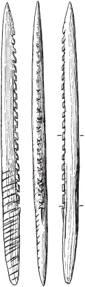
Figure 2.1
The Leman and Ower harpoon, dredged from the floor of the North Sea. Two thirds full size. Courtesy: The Prehistoric Society.
The mystery began to unravel when Victorian geologist Clement Reid, who worked for the Geological Survey, became fascinated by the stunted tree stumps from long-vanished forests uncovered at low tide along the eastern English coast.
3
Blackened oak stumps, hazel, and alder trees, and the bones of extinct animals came from the once-flourishing forests. None other than the diarist Samuel Pepys had noted ancient hazel fragments preserved in the filthy mud of Thames dockyards. How had such dense forests vanished under the waves? Inevitably, in a devout age, even expert scientific observers assumed the trees had succumbed to the biblical flood. And equally inevitably, they became known as Noah’s Woods. Everyone except Clement Reid shunned the half-submerged
forests, mantled as they were by glutinous mud and filth, and awash at high tide. As one expert wrote, they “belong to the province of geology, and the geologist remarks that they are too modern to be worth his attention.”
4
Reid was the first scientist to gaze under the heaving surface of the North Sea. He wrote of an extensive alluvial plain that had once covered the entire southern North Sea, about thirty-six meters below modern sea level. Judging from the plant remains, much of this submerged land was marsh and fen, protected by extensive sand dunes and crisscrossed by major rivers linked to the modern-day Rhine and Thames. Clement Reid never named his submerged land. Nevertheless, he published his findings in a short essay,
Submerged Forests
, which appeared in 1913, described in his obituary as “a delightful little book.” “Nothing,” he said, “but a change of sea level could account for the coastal forests.”
5
He noticed that the Humber and Thames valleys cut about eighteen meters below modern ground level and found a similar horizon over wider areas. Perhaps a plain that lay far below today’s land surface and sea level flanked these large rivers. Boldly, Reid extrapolated his sunken ground surface to a submerged plain that covered the entire southern North Sea.
6
Clement Reid died in 1916, leaving a drowned, anonymous land behind him and a prevailing scientific opinion that the southern North Sea had been a vast fen, not a useful landscape, but one that people crossed on their way to higher ground. There matters remained for years, despite the development of a new scientific method for studying marsh deposits, developed in Scandinavia during Reid’s closing years. Palynology, otherwise known as pollen analysis, studied minute fossil pollens preserved in marshes and peats. Two Cambridge botanists, Harry and Margaret Godwin, persuaded the skipper of the
Colinda
to return to the Leman and Ower, where they obtained samples of moorlog for pollen analysis. (The original block that contained the harpoon had been thrown overboard.) The Godwins soon showed that the moorlog came from a deposit that had formed in freshwater. So the
Colinda
’s harpoon had not been lost at sea but dropped on land. Cambridge archaeologist Grahame Clark, a friend of the Godwins, wrote a seminal book entitled
The Mesolithic Settlement of Northern Europe
in 1936, in which he not only described rich post–Ice Age hunter-gatherer societies in Scandinavia but also waxed lyrical about the favorable prehistoric environments that now lay under the North Sea—a land bridge to higher ground.
7
By the 1990s, geologists and geomorphologists had collected vast reservoirs of information about the North Sea bed as part of oil exploration. They established that sea levels had risen no less than 120 meters since the last Ice Age maximum, inundating an area larger than the entire United Kingdom. However, their research was short on topographic detail, the kind of information that archaeologists need to survey an area for potential sites.
At this point, the archaeologists sat up and took notice. In 1998, one of them, Bryony Coles of the University of Exeter, published an important paper in which she summarized all the evidence that bore on the ancient North Sea landscape, from about twenty thousand years ago up to the final disappearance of the landscape in about 5500 B.C.E.
8
She called the sunken landscape Doggerland and produced a series of maps based on bathymetric contours that chronicled the slowly vanishing land surface. At the height of the last glaciation, the North Sea did not exist. Land extended from the Shetland Islands to Norway. As sea levels rose, the coastline slowly receded, forming a large inlet, with the Dogger Hills on the eastern side of the narrowing sea. Eventually, as the sea rose ever higher, the Dogger became an island before itself vanishing beneath the waves. Coles’s hypothetical maps sparked a new generation of research, in the belief that what had happened on higher ground, especially in Britain, might well have been peripheral to what had happened below modern sea level. However, the murky and turbulent waters of the North Sea were seemingly as inaccessible to archaeologists in 2000 as they had been in Clement Reid’s day.