The Attacking Ocean (7 page)
Read The Attacking Ocean Online
Authors: Brian Fagan
Tags: #The Past, #Present, #and Future of Rising Sea Levels

Figure 2.3
Artist’s reconstruction of life in a Doggerland hunting camp, ca. 7000
B.C.E.
© Bob Brobbel.
Everywhere in this sunken land, people lived at the mercy of the rising ocean, for, even within generational memory, seawater would inundate mussel beds and beaches where their ancestors had once gathered food. Rivers would alter course without warning; severe winter storms would bring storm surges and exceptionally high tides; sand dunes would encroach on favored wetlands. The water was inexorable, ever intrusive, never retreating, to the point that high tide marks became low tide levels within a few years. Once-conspicuous ridges became islands surrounded by shallow water. As the waters rose, so each band adjusted easily to more restricted territories or moved to higher ground.
Doggerland became more and more of a watery world, dotted with ever-larger lakes and increasingly sluggish rivers that overflowed their banks, their gradients reduced by higher sea levels. Century by century, the wetlands vanished as the North Sea gradually became a complex archipelago of islands. The largest was the Dogger Hills, which remained above water long after the rest of Doggerland had vanished. By that time, most people had moved to higher ground in what is now the Low Countries or Britain. Increasingly, Doggerland must have remained only as a folk memory, as a realm of vanished lands once inhabited by
revered ancestors. The gray, muddy waters with their violent storms and short, steep waves became the home of the dead, of those who came before. As for the dead themselves, at least some of them were buried on islands amid the waters, if analogies from higher ground are to be trusted. As the waters rose and the islands vanished, so the dead entered the place of those who went before, remembered only in oral tradition and folk memory. We know of such burial places from Somerset in southwestern Britain, where local hunters buried their dead on a low island amid the wetlands of what are called the Somerset Levels.
By about 5500 B.C.E., after ten thousand years, Doggerland had become the North Sea. The last of the Dogger Hills had vanished. The former inhabitants of what was now ocean had long before moved to higher ground, but many of them remained along still gradually flooding coastlines and estuaries nearby. The densest populations were along Baltic shores and especially in Denmark, where hundreds of abandoned campsites lie both at higher elevations and in shallow water. Such waterlogged locations have proved a treasure trove of rarely preserved archaeological finds such as fishing nets and traps, antler, bone, and wood spears, even paddles and rare dugout canoes. At the Ulkestrup site in Denmark, people lived in large huts with bark and wood floors on a peat island nestled in a swamp by a lake. One hut lay close to where canoes were once moored. These were people who thrived, as Doggerland refugees did, near shallow water and wetlands, where they preyed on fish, mollusks, and waterfowl.
As warming continued, populations rose in the most favored coastal areas. Hunting territories became progressively smaller. For example, the Segebro settlement near the southwestern Swedish coast now lies in brackish water. The small encampment close to the water once covered fifty by twenty-five meters. The inhabitants lived there year-round, but mainly in spring and summer. Carbon isotope analysis of their bones shows that fish and sea mammals made up 60 percent of the diet. Nevertheless, they enjoyed an omnivorous diet. The remains of no less than sixty-six animal species lay in the site.
By 4600 B.C.E., about a thousand years after the final inundation of Doggerland, many hunting bands lived in more or less sedentary
settlements, often occupied for months at a time. Territories were smaller, the boundaries more closely defined, for prime hunting grounds had shrunk in the face of rising seawater. With much greater population densities in the richest and most diverse environments, local societies became more complex, their artifacts and art styles more diverse, as if cultural differences were assuming greater importance. Differences there may have been, but there are signs that neighboring groups remained in contact, trading such commodities as tool-making stone over considerable distances. At the same time, the food quest intensified in the face of greater crowding.
Such an intensification of the food quest was inevitable in a changing world of increasing competition for valuable food resources. Neighbors eyed nearby oyster beds or fishing grounds; hunters quarreled over who had the right to take migrating waterfowl resting on small lakes in spring or fall. The ownership of salmon runs and eel-rich bays must have led to feuds and occasional violence. No longer could people move away and explore vacant land. Now their neighbors were close by and territorial boundaries became increasingly sacrosanct as people stayed in more or less permanent settlements anchored closely to their ancestral lands. Sometimes there may not have been enough food to go around.
With sedentary settlements, many communities now buried their dead in cemeteries. In the cemetery at Vedbaek Bogebakken in Denmark, used around 5000 B.C.E., twenty-two people of different ages lie in shallow graves.
13
Some perished after violent deaths, one lying with a bone point embedded in his throat. A few burials will never provide a full or accurate picture of violence along these changing shores, but the signs of stress—of increasing crowding—are there in a world where the sea pressed aggressively on the land. There was far less hunting territory to go around. For thousands of years, the hunters of Doggerland had moved constantly in the face of rising seas. Now their primordial homeland had vanished to the distant recesses of human memory, but the still-attacking sea compelled their remote descendants to settle in one place, to exploit a far wider range of foods, and moved some of them to competition and violence.
For thousands of years, a sparse population of hunters and foragers
had engaged in an intricate minuet with the ocean that lapped at their proverbial doorsteps. Even a large band would stay for only a few years at a favored water’s-edge location before moving elsewhere as dry land and marsh vanished underwater. Generational memory and cherished oral traditions would have underlain a way of life defined by movement, not environmental change. Now the equations of daily life were changing. People lived in larger settlements occupied for decades, even centuries. They could still respond to an attacking ocean by moving, but the process was more intricate and thwart with complex social realities, many of them defined by ancestral ties to hunting territories and fishing grounds. In these changes, we can detect the first signs of a pervasive human vulnerability to sea level change in a slightly more crowded world.
The sea of marmara, Turkey, 5500 B.C.E. A powerful winter storm sweeps up the constricted strait. Great breakers thunder on a low-lying sandy beach at the upper end. Spray flies. The water level in the sound rises with the mounting storm. High surf flows up small gullies farther ashore, then recedes, eroding slender defiles and forming inlets. When the wind drops and the water recedes, the ridge, an ancient pathway that separates the Mediterranean from the great lake far below, is narrower than ever before. Each spring local farmers cross the shrinking berm with their flocks toward the higher ground to the west. Each fall, they return, following paths used since time immemorial. As their beasts crowd the track, the shepherds glance down at the ruffled blue waters of the lake far below, where lush water meadows nourish winter pastures.
Year after year, the defile becomes narrower. Storm after storm, the erosion persists as sea levels rise almost imperceptibly. Steep waves eat away at the beach and sandy cliffs. Then, inevitably, at the height of a major storm, surging water from a set of steep breakers bursts through to the slope on the other side. The damage is done, a channel formed. Wave after wave deepens the furrow, until seawater courses through even in calm weather. Now the inexorable force of gravity takes over. The inlet becomes a saltwater outlet that flows deeper and wider. Within days, the gully becomes a torrent, then a rushing waterfall that carries water flowing at over ninety kilometers an hour. The deeper the water cuts into the berm, the faster it flows. Modern-day estimates tell us that
enough water passed through each day to flood Manhattan to a depth of almost a kilometer. Within weeks, the Euxine Lake rises rapidly, perhaps as much as fifteen centimeters a day. After two years of inflow, the Euxine Lake filled to the same level as the Mediterranean and became a brackish ocean, now known as the Black Sea.
DURING THE LATE Ice Age, the Mediterranean (sometimes called the Middle Sea) had been a chilly, much smaller ocean, often swept by vicious northerly winds that brought subzero temperatures and bitter cold. For the most part, the sea level rise had been steady and unspectacular, bringing changes that impacted coastal peoples on, at most, a generational timescale. The flooding of the Euxine Lake was a geological event on a different, potentially catastrophic scale, far more life threatening than the inundation of Doggerland. We know of the flooding from deep-sea cores that chronicle the changing salinity of the water from tiny diatoms and other clues. We also know that the inundation originated in happenings on the far side of the Atlantic, when the great Laurentide ice sheet covering northern Canada finally collapsed. The ice had retreated rapidly after fifteen thousand years ago, as global sea levels began rising in the face of rising temperatures. By about 6200 B.C.E., huge meltwater accumulations finally undermined the shrinking ice sheet. The Laurentide imploded. A massive outflow of meltwater from a large glacial lake, Lake Agassiz, cascaded into the North Atlantic and the Gulf of Mexico. Sea temperatures cooled rapidly. The great ocean conveyor belt that drives the Gulf Stream in the North Atlantic slowed.
1
Like a light switch, the slowing circulation tamed the moist westerlies that brought rainfall to Europe and the eastern Mediterranean. The Balkans and eastern Mediterranean suffered under severe droughts, so much so that many farming societies abandoned their villages as lakes dried up and rivers and streams withered in the cool, arid conditions that lasted for some four centuries.
This was not the first cold snap to affect Europe and the Middle East after the Ice Age. A similar episode, the Younger Dryas, also caused by
melting ice, had at least partially shut down the Gulf Stream six thousand years earlier and brought cold and drought that endured far longer, for at least ten centuries. That long drought cycle had seen hunting societies in the Middle East switch from a close dependence on nuts and wild grasses to cultivating cereals and domesticating animals. The switchover to farming, an entirely logical response to shrinking wild grass stands, may not have been easy, but it was to revolutionize human history. As the cold snap and accompanying droughts eased, the new farming economies had spread rapidly throughout the Middle East and along the eastern Mediterranean coast.
2
The farmers sought out easily cultivable fertile soils, many of them on river floodplains and near lakes. There they thrived until dry, cold conditions returned, when persistent droughts anchored many villages to rare, permanent water supplies. Once such refuge would have been the shores of the Euxine Lake, formed in a huge basin by meltwater from northern ice sheets.
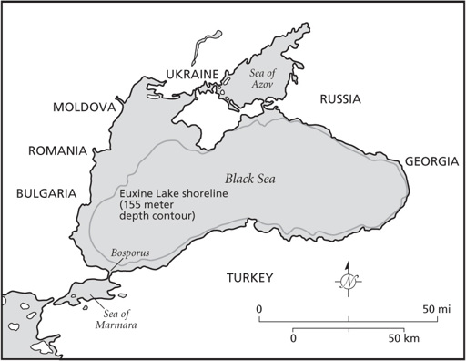
Figure 3.1
The Euxine Lake.
The Euxine Lake lay some nine hundred meters below the Anatolian Plateau in what is now Turkey to the south, where farmers had settled many centuries earlier. Perhaps the lake basin formed a large oasis. Temperatures around its shores would have been considerably warmer during the cold centuries, water plentiful, and the soils fertile. Pollen grains from deep-sea cores show that the coastal plains around the lake supported grassland and steppe. Farming here did not require large-scale forest clearance, a challenge for people with stone axes. Most likely a denser concentration of people lived around the Euxine than elsewhere. They would have dwelled in small villages, clusters of mud-brick houses linked by small alleyways, surrounded by patchworks of fields and pastures. There may have been occasional larger communities, especially in locations close to sources of such valuable commodities as tool-making stone. Like their distant contemporaries throughout the Middle East, they would have had close ties to land that had been farmed for generations, since the time of their ancestors.
Sedentary farmers these people might have been, but they also relied on hunting, fishing, and foraging during lean months, living as they did in less crowded landscapes than those of later times. Their agriculture depended on cultivating carefully selected patches of lighter, easily turned soils, which meant that extensive tracts of uncleared landscape surrounded their settlements, an edible landscape rich in wild plants where game abounded. This gave them flexibility that enabled them to subsist off foods other than their crops and stocks of stored cereal grain for considerable periods of time. Then, abruptly, climate change unsettled everything.