Maphead: Charting the Wide, Weird World of Geography Wonks (16 page)
Read Maphead: Charting the Wide, Weird World of Geography Wonks Online
Authors: Ken Jennings
Tags: #General, #Social Science, #Technology & Engineering, #Reference, #Atlases, #Cartography, #Human Geography, #Atlases & Gazetteers, #Trivia

Stealing antique maps sounds like such an esoteric niche of felony that it’s hard to believe it’s becoming commonplace all over the world. In fiction, a sudden rash of old map thefts would mean only one thing: a cunning new criminal genius in town. (“Holy hachured contour, Batman! It’s the Cartographer!”) But when real-life map thieves are apprehended, they’re disappointingly ordinary: desperate, underpaid misfits from the world of rare books or academia. In fact, their obvious nonmastermind status explains the recent popularity of this kind of crime: maps are pilfered because they’re so easy to pilfer.
It’s the nature of the beast: the whole purpose of a library is to make rare materials available to the public. These materials are valueless if
nobody
can see them. It’s hard to spirit a big bulky book out of a reading room—they get checked in and out carefully—but removing pages is, as Gilbert Bland and Forbes Smiley have demonstrated, heartbreakingly easy. (Smiley might never have been caught if not for a fluke: he accidentally dropped his knife.) They’re light and small, and their absence might not be noticed for years. But which pages to remove? “
If you take
a page out of a rare book, you’ve got a worthless piece of paper,” says Tony Campbell, a former map librarian at the British Library. “But if you take a map, you haven’t destroyed its worth. It’s likely to have a fair value, and it’s virtually untraceable.” Maps, unlike books or paintings, are almost never sold with a provenance; their history, a cartographer might say, is Terra Incognita. Most
often, they bear no identifying marks at all. (Yale was able to prove ownership of Smiley’s maps only by matching up wormholes with those on adjacent pages.) During the Smiley trial, the defense made much of the fact that many of the institutions he targeted reported maps missing that he had never handled or that later turned up elsewhere in their archives. Libraries, frankly, don’t always know what they have, especially if little larcenies like this have been going on under the radar for decades, as seems likely.
Despite the gloomy predictions of some dealers, the map trade didn’t collapse with Forbes Smiley’s downfall. Even in a major recession, sales have been strong and prices have stayed high. The antiquarian world, having lost its innocence, has begun to take precautions: libraries are keeping a closer eye on patrons, and dealers and auction houses are becoming more inquisitive about the provenance of the items they buy. For many years, “tome raiders” like Smiley were tacitly abetted by their victims—institutions were reluctant to report missing items, since the security lapses were embarrassing and might discourage future donors while encouraging future thieves. That’s now starting to change. Map librarians share more information on losses as they happen, so that dealers and auction houses know to be on the lookout for specific missing items, as the art world has done for decades. But there’s still no central online index of thefts and no map dealer who requires proof of title every time a map is offered for sale.
As much as I love maps, I’ve never felt the need to possess them. I understand the completist instinct of the collector, but I’ve always regarded maps as a kind of public utility. Like a nice sunset, I can look at one without wanting to take it home. But the recent crime wave in cartography demonstrates that maps do exert that kind of pull over many, many people. Not every map thief is a Forbes Smiley, stealing big-ticket items and quickly reselling for fear of losing a cabin on Martha’s Vineyard. Many just see a beautiful map and
have to have it
. My favorite case is that of
Farhad Hakimzadeh
, a wealthy London publisher sent to prison in 2009 for scalpeling hundreds of thousands of dollars’ worth of maps and illustrations out of rare books in London and Oxford libraries. He had no plans to resell, he told the court—he was just deeply attached to his collection and couldn’t help wanting to
improve it. He testified that, on his wedding night, he even kept his new bride waiting in bed while he polished the covers of his beloved rare books. Perhaps she misunderstood when he warned her he was into “leather binding.”
The world’s most distinguished collectors of maps may keep their treasures very private, but luckily for me there’s a second tier filling out map societies around the world: the garrulous amateur enthusiasts. Leonard Rothman, a longtime Annapolis gynecologist who retired to California a decade ago, is one of them. “I love to expound,” he says as he welcomes me into his thirty-first-floor condo in San Francisco’s posh Russian Hill neighborhood. “I’m not allowed to mention maps when we have people over. I get in trouble.” In fact, he can’t help talking about every map we pass as we walk across the Persian rugs in his entry-way. The vignette on this John Tallis map is supposed to be a giraffe, but clearly the engraver was working from vague secondhand descriptions—it looks more like a kangaroo with a bad case of acne. The outline color on that map—rust and teal, like two-strip Technicolor—is a dead giveaway as to its German origins, and you can even tell how old it is by how the pigments have oxidized. A cabinet holds part of a collection of almost one hundred thirteen-inch globes. Most are antiques, but one is from the 1998 World Cup and plays the anthem of each competing nation when you press its corresponding flag.
“I’ve never seen that before,” says Phil Simon, pointing at a strangely elliptical globe on a lower shelf. Phil, a retired United pilot, is the president of the California Map Society and has come with me to take a look at his friend’s collection. In his sixties, he’s a grandfatherly man with bushy black eyebrows and a penchant for sweater-vests.
Leonard is delighted to have the oddity noticed. “You know what that is? It’s an ostrich egg!”
“That’s a beauty! Who made it?”
“Who made it? The ostrich made it.”
We sit on Leonard’s terrace, which gives us a breathtaking three-hundred-degree view of San Francisco on a cloudless day, from the Golden Gate Bridge in the northwest all the way around to the Bay
Bridge eastward. We’re on top of the tallest building on one of the city’s highest hills, which might make us the uppermost people in the city right now. (I can’t tell if we’re quite higher than the tip of the Trans-america Pyramid or not.) When I mention this to Leonard, he points out that there’s actually a penthouse above us; his upstairs neighbor is no less than George Shultz, longtime secretary of state under Reagan. “And his deck keeps leaking onto our ceiling!” he complains.
Yes, this is what even the middle tier of serious map collecting looks like: an elite world where the most serious annoyances are the leaky hot tubs of former Cabinet officials. There may still be entry-level maps around, but, by and large, soaring prices have made this a hobby for the affluent. But Phil and Leonard still get moony when they talk about the
real
elite West Coast collectors, the David Rumseys
*
and the Henry Wendts. “Leonard and I will
never
amass a collection like Wendt’s,” sighs Phil. “This man is
extremely
wealthy. One of his maps, there’s only five of them in the world.”
Maps have been luxury items ever since the Renaissance, when there are the first records of people collecting them. It was fashionable at the time for wealthy Dutch burghers, German nobles, and Italian merchants alike to keep “cabinets of curiosities”—little home museums full of rarities.
†
Back then, the idea of owning things and looking at them as a pastime was so novel that you weren’t necessarily a collector
of
anything specific, like coins or seashells or porcelain. You were just
a collector,
full stop. You wanted it all, and the world was still limited enough for that to be a reasonable goal. Surviving inventories of such chambers reveal
an amazing hodgepodge
made possible by the new age of exploration: belts of Brazilian cannibals embellished with
the teeth of their devoured victims, rhinoceros horns encrusted with rubies, books from Malabar printed on palm leaves, stuffed pelicans, “eighty faces carved on a cherry stone,” “an instrument used by the Jews in circumcision.” Maps and globes were nearly always part of the display, both to provide context for the wide-ranging collection and because they were valuable items in and of themselves.
This was a watershed moment in the history of cartophilia. For thousands of years, people had drawn maps because they had to: to get from one place to another, or locate taxpayers, or mark the boundaries of fields and pastures. If not for those maps, lives or property would be lost, governments might fall. But here, for the first time, we have evidence of people keeping maps just because they liked looking at them. John Dee, the court astrologer and alchemist to Queen Elizabeth I, noted the fad in 1570, writing that the hobbyists bought maps with three purposes in mind: “
some to beautify their halls
, parlours, and chambers with,” “some other[s] to view the large dominion of the Turk, the wide empire of the Muscovite, and the little morsel of ground where Christendom . . . is certainly known,” and “some others . . . to understand other men’s travels.” Many of the great men of the time were map geeks. During his wild Oxford days, Thomas Hobbes “
took great delight
there to go to the bookbinders’ shops and lie gazing on maps.” (Those political philosophers know how to party!) The diarist and secretary of the Admiralty
Samuel Pepys had
a vast map collection, though he lost his beloved John Speed atlas in the Great Fire of London.
A recent study of old Cambridge records has found that,
by 1560, a quarter
of all book owners owned maps and atlases as well. Half displayed them proudly on their walls, as can also be seen in many oil paintings of the time. Jan
Vermeer was a particular map fan
, faithfully reproducing period maps in the backgrounds of more than a quarter of his surviving canvases. In many cases, he seems to have gotten so carried away that his figures are dwarfed by an enormous map: the 1636 Claes Jansz. Visscher map of the Seventeen Provinces of the Netherlands in
The Art of Painting,
for example, or the 1620 Balthasar Florisz. van Berckenrode map of Holland above the
Officer and Laughing Girl
. The fact that early collectors were so proud to display
their maps tells us that there may have been some self-interest at play here, beyond just an idle aesthetic or intellectual pursuit. Displaying maps gave you prestige; it was easy shorthand for “See how educated I am!” or “See how far-reaching my business interests are!”
*
A college sophomore is hoping for the same effect today when he casually adds a German beer stein or a poster of the Montmartre steps to his dorm room decor after returning from a summer in Europe.
The collectors then must have been very different from today’s model. Back then, sixteenth-century maps had no patina of age and history, of course—they were contemporary items, hot off the presses. For Leonard and Phil, one of these maps will conjure up a bygone time, but to its first owner, the same map was like a “Breaking News” update on CNN, the first place they could see the latest discoveries about the world outside Europe. It occurs to me that an adult collector then may have looked at maps with an eagerness and curiosity that only children can view maps with today: the joy of seeing an unknown part of the world for the very first time.
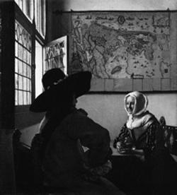
Detail from Vermeer’s 1657
Officer and Laughing Girl.
Would you care for a little painting with your map, Mr. Vermeer?
Until a wider variety of maps became available in the late sixteenth century, the Cambridge study found, collectors were interested in only two kinds of maps: world maps and maps of the Holy Land. When Leonard decided to focus his collection, he chose Holy Land maps as well. His map library now holds nine hundred such maps, including at least one from every cartographer who ever charted Palestine.
“Why the Holy Land?” I ask.
“There was a lot of stuff that was cost-effective. I’d been to Israel a few times, but the real thing was, I wanted to do something unique, something different.” While still a practicing physician, he tells me, he once presented a paper on a rare pregnancy disease. Because there were only thirty-five recorded cases in history, he became the world’s leading authority. “In other words, if you’re going to specialize, specialize as much as possible.”
“And it probably had something to do with your Jewish faith or heritage?” I venture.
“No! Why would I hang pictures of Jesus on my wall?” Sure enough, almost every map on display has a large vignette of the Crucifixion adorning Jerusalem. Many of the great early cartographers were Jewish,
*
but Holy Land maps were almost always made with Christian devotion in mind. “Once you become a collector”—he shrugs—“you have to keep an open mind.”