The Attacking Ocean (24 page)
Read The Attacking Ocean Online
Authors: Brian Fagan
Tags: #The Past, #Present, #and Future of Rising Sea Levels

Quite apart from staples like dolphin and salmon, every Jomon village close to shore clubbed seals when rookeries were nearby. The entire coastal landscape created by rising sea levels was an ancient supermarket of different foods—crabs and oysters, and shellfish of all kinds, many of them taken by diving into deeper water. Some Jomon skeletons display the characteristic abnormal growth in the ears found in many modern divers. It’s no coincidence that huge shell mounds accumulated around Jomon villages in places where mollusks abounded. They were an invaluable staple, especially when fish or plant foods were in short supply during the winter months.
Anyone living by the shore learned about the ocean landscape literally from birth. They acquired knowledge from their parents, from elders and fellow kin, and from hard-won experience on the water and on shore. If the Jomon were like other hunting societies, they would have lived in an intensely symbolic world, where ceremonies and chants, dances, myths, oral traditions, and songs, both connected them with
the spiritual world and defined the cosmos, its benefits, dangers, and hazards. And part of this complex ritual tapestry would have been memories of great tsunamis and powerful earthquakes, carefully recounted so as to prepare everyone for sudden flight to higher ground when an earthquake struck. Such behavior would have been as much a part of daily existence as preparing a meal or harvesting nuts.
Just as they did in Europe, rising sea levels nurtured rich inshore fisheries, while post–Ice Age warming created much richer environments onshore. Most Jomon communities relied heavily on plant foods, especially the rich fall nut harvests, which yielded millions of chestnuts and walnuts, and also horse chestnuts and acorns. Nuts have huge advantages; not only are they nutritious, but they can also be stored for months, even years, in pits or granaries. Jomon foragers stored the harvests in subterranean pits up to 1.8 meters deep. With such diverse and plentiful food sources at hand, population densities rose steadily, especially in parts of food-rich eastern Japan, so much so that the most favored areas became crowded and hunting territories more circumscribed. There may have been food shortages, too, especially of easily stored nuts. In response, Jomon communities made increasing use of carbohydrate-rich acorns, which require labor-intensive shelling, then grinding before processing them to remove the bitter tannic acid, which has to be leached away by immersing the ground nuts in water or by flushing water through a pile of nuts in a hollow.
5
No one knows how large the population was after thousands of years of successful fishing and foraging, but one conservative estimate speaks of some 250,000 Jomon people throughout the islands. Their villages were certainly thick on the ground, especially in food-rich areas. Some of them boasted of more than fifty houses, many located close to water’s edge. Population densities rose so high in some regions like Tokyo Bay that individual territories for each settlement may have been as small as five kilometers across. A combination of higher numbers and more permanent settlement increased Jomon vulnerability to tsunamis, but it was a vulnerability mitigated by strongly centered cultural traditions that stressed movement in the face of disaster. There may have been tsunamis aplenty during the Jomon millennia, but casualties must
have been relatively small when everyone knew instinctively what to do when a strong earthquake shook coastal villages.
Local populations waxed and waned over the centuries, but increasingly complex Jomon societies flourished for more than ten thousand years. They thrived through thousands of years of often abruptly changing environmental conditions and warming, and into the period of more stable sea levels, which took hold all over the world around 4000 B.C.E. They adapted to rising sea levels—as did hunter-gatherers elsewhere. A remarkably high level of cultural continuity, and presumably a high degree of adaptiveness to tsunamis, endured over the islands until as late as 300 C.E., when new rice-farming societies, known collectively as Yayoi, came into being in the south.
One uses the words “came into being” advisedly, for controversy reigns over exactly what happened. For many centuries there had been at least sporadic contacts between Jomon communities and Korea, some two hundred kilometers away, but it was not until about 400 B.C.E. that these contacts intensified with the arrival of rice paddy cultivation, domesticated pigs, and full-time farming in Japan. On the southwesternmost island, Kyushu, the farmers may have grown rice in the paddies during the warm summers, then drained them for dry cultivation of cereals like millet and wheat in the winter. This highly productive form of intensive agriculture triggered rapid population growth as farming spread rapidly northward as far as Honshu within three hundred years. Whether this was a case of Jomon people adopting a totally new way of life, or the arrival of significant numbers of migrants from Korea, where similar artifacts to those of Yayoi farmers are found, is a much-debated and unresolved question. In the much cooler far north, rice farmers had no hope of competing with hunters and gatherers. Northern Honshu was the frontier between farming and the ancient lifeway, which survived in the hands of the Ainu people, genetic descendants of the ancient Jomon, until modern times.
WHEN THE GREAT tsunami of March 11, 2011, thundered ashore along the coastline around Sendai in northern Japan, huge waves swept away
everything in their path. But Jomon sites dating to around 4500 B.C.E. on the hills and terraces above the shore at Satohama in Matsushima Bay remained unscathed.
6
These extensive sites lie some twenty to thirty meters above sea level, out of reach of almost all tsunami waves. Later Jomon sites lie at slightly lower elevations, while artifacts left by rice farmers from the ninth to twelfth centuries C.E. lie around today’s high water mark. Were the inhabitants of Satohama in the ancient times aware of tsunamis? We can be sure that the Jomon had experienced them, which may be why they built some of their villages well above sea level. The pattern of settlement changed with Yayoi rice-paddy farmers, who required low-lying, easily inundated land, such as lay on coastal plains. Higher population densities, more people packed into the landscape, all of them anchored closely to their fields and paddies: The threshold of vulnerability now rose dramatically, especially since a surging tsunami left standing water behind, so sea salt percolated into the soil and rendered land uncultivable for generations. The crowded landscape would also make it much harder for people to escape in large numbers to higher ground.
Thanks to an accident of preservation, we know that tsunamis hit the coast during Yayoi times. About two thousand years ago, rice farmers at Katsukata near Sendai on the northeast coast built extensive rice paddies, which survive in a waterlogged state, so well preserved that both footpaths and human footprints survive. The archaeologists’ trenches revealed a thick layer of sand that covers the paddies, deposited by a great tsunami that destroyed rice fields over a large area. Nothing was grown there for four centuries. We have no means of knowing how many people perished in the disaster.
Japan’s tsunamis come into sharper focus in later times, when written records provide at least a hint of their frequency.
7
We know that at least 195 tsunamis struck Japan over a period of 1,313 years up to 1997, with such an event averaging every 6.73 years, the highest incidence in the world. A major tsunami followed the Great Hakuho earthquake of November 29, 684 C.E., but no death count survives. The Sanriku earthquake and tsunami of 889 raged ashore in the Sendai region of the northeast and completely destroyed the town of Tagajo, drowning a
thousand people. In 1498, six years after Columbus landed in the Bahamas, 30,000 to 40,000 deaths followed a 7.5 earthquake and tsunami. Two centuries later, in 1605, an enormous tsunami caused a water rise of thirty meters affecting much of the Boso Peninsula and Tokyo Bay. At least 5,000 people perished. The litany of death and destruction unfolds inexorably, with a steady increase in the number of casualties. Another tsunami swept ashore on the Sanriku coast in 1896. Thirty-meter waves killed 27,000 people. By this time, the coastal population had mushroomed, with densely packed, growing cities like Tokyo, where an earthquake, tsunami, and fire in 1923 killed over 100,000 people.
How, then, does one protect an increasingly crowded coastline from tsunamis? Back in 1896, after the Sanriku tsunami, which boasted of waves up to forty meters in places, local celebrities encouraged people to move to higher ground. The government did nothing. Inevitably those who had relocated to greater elevations returned gradually to the lowlands where most people lived. In 1933, when another tsunami struck the same shoreline and caused casualties, the government moved forward aggressively with prototypes for tsunami defenses.
8
After further disasters, concrete seawalls came into use, first in Osaka, then elsewhere, at a time when tsunami forecasting was becoming more effective. By the 1960s, construction of coastal defenses was in full swing, most of them dikes up to six meters high, which were considered sufficient to retain minor tsunamis and storm surges from typhoons. However, these proved ineffective against major events. Today, a combination of seawalls, urban defenses, and preparedness on the part of the public appear to be most effective measures, except in the case of really major tsunamis when most bets are off, even when forecasting systems are as close to instantaneous as they can be, like they are today. There are only minutes of warning, even with state-of-the-art communications.
Concrete seawalls, breakwaters, and other protective measures designed to guard against high waves, typhoons, and tsunamis now protect at least 40 percent of Japan’s 35,400-kilometer coastline.
9
Most of them lie in areas where the government estimates that there is a more than 90 percent chance that a major earthquake will occur within the next three decades. One of these stretches of coastline lay just where the great
tsunami of 2011 struck. Great waves overwhelmed the sea defenses in minutes. Over 20,000 people perished in a catastrophic demonstration of human vulnerability in an overcrowded, urban world.
10
THE 9.0 UNDERWATER Tohoku earthquake that caused the tsunami shook the eastern Pacific at a depth of thirty-two kilometers on March 11, 2011. The epicenter was about seventy kilometers east of the Oshika Peninsula. The nearest large city was Sendai, about 130 kilometers away. The seabed rose by several meters. Parts of northern Japan moved as much as 2.4 meters closer to the United States. A 400-kilometer stretch of the Japanese coast sank by 0.6 meter, which allowed the resulting tsunami to travel faster and farther inland.
The huge tsunami devastated the coastline of Japan’s northern islands. A 670-kilometer stretch of coastline from Erimo in the north to Oarai in the south experienced the full fury of the waves, which overwhelmed defense walls built in anticipation of far lower surge heights. Towns, villages, and ports were destroyed, bridges washed away. Just over an hour after the earthquake, tsunami waves swept ashore and inundated Sendai Airport, sweeping away cars and aircraft and flooding buildings. Motorists on surrounding roads tried vainly to outrun the water but were engulfed in moments as the tsunami flooded the town. Surging water inundated designated tsunami shelters.
It’s hard to grasp the devastation caused by an event like this, the powerlessness of humanity against the pitiless sea. Videos shot during the tsunami show the waves racing ashore, piling up, bucking and tumbling houses one against another like pebbles, surging over larger buildings as if breaking against cliffs, then crumbling them. A haze of foam, spray, and moisture rises high into the air like a moving fog bank. Many coastal towns were left little more than piles of collapsed rubble. Survivors wandered in bewilderment and shock through the ruins looking for family and relatives.
Over 46,000 buildings lay in ruins or were totally destroyed, more than double that number seriously damaged. Fishing boats grounded far inland. The damage to infrastructure was immense, including wide spread power failures that led to rolling blackouts, and also to cracks in irrigation dams. Most sobering of all was serious damage to three nuclear power plants, all of which shut down automatically after the earthquake. But tsunami waves swept over seawalls at the Fukushima reactors and flooded the backup diesel generators that provided emergency cooling, which lay rashly close to sea level. A major meltdown ensued; 200,000 people were evacuated; the long-term damage is still being assessed, especially the dangers from radioactive contamination of food, soil, and water supplies. In all, more than 300,000 people were directly affected by the disaster, many of their homes permanently destroyed.
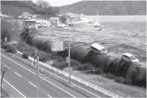
Figure 10.2
A tsunami wave crashes ashore at Miyako City in northeastern Japan, March 11, 2011. Hitoshi Katanoda/Polaris/Newscom.